
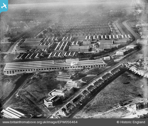
EPW056464 ENGLAND (1938). The Celotex Ltd factory and environs at Stonebridge Park, Alperton, 1938
© Hawlfraint cyfranwyr OpenStreetMap a thrwyddedwyd gan yr OpenStreetMap Foundation. 2026. Trwyddedir y gartograffeg fel CC BY-SA.
Delweddau cyfagos (48)
EPW056464

EPW056463

EPW056415
, Alperton, 1938")
EPW056465

EPW056461

EPW056762

EPW051680

EPW056460

EPW056417
, Alperton, 1938")
EPW056418
, Alperton, 1938. This image has been affected by flare.")
EPW056416
, Alperton, 1938")
EPW056466

EAW026667

EPW056420
, Alperton, 1938")
EPW056757

EPW051673

EPW056462

EPW056759

EAW026662

EPW056419
, Alperton, 1938")
EPW056414
, Alperton, 1938")
EAW026664

EAW026665

EPW056086

EAW026663

EAW026668

EPW053020

EPW056761

EPW056088

EAW026666

EPW053019

EPW051676

EPW051675

EPW056760

EAW017038

EPW053021

EAW017045

EAW017037

EPW051674

EAW017043

EAW017044

EPW056763

EAW017040

EPW051678

EAW017041

EPW056758

EAW017042

EPW053018

Manylion
| Pennawd | [EPW056464] The Celotex Ltd factory and environs at Stonebridge Park, Alperton, 1938 |
| Cyfeirnod | EPW056464 |
| Dyddiad | 9-March-1938 |
| Dolen | |
| Enw lle | ALPERTON |
| Plwyf | |
| Ardal | |
| Gwlad | ENGLAND |
| Dwyreiniad / Gogleddiad | 519142, 183786 |
| Hydred / Lledred | -0.28184793387745, 51.539904032058 |
| Cyfeirnod Grid Cenedlaethol | TQ191838 |
Pinnau

Geoff Lumley |
Saturday 28th of April 2018 09:03:28 PM | |
|
Rudgey |
Friday 23rd of September 2016 01:49:23 PM | |
|
Harrow&Wembley |
Sunday 1st of December 2013 02:48:11 PM |
Cyfraniadau Grŵp
I see the cutting continues towards the Brent. The purpose of the cutting still eludes me. |
Harrow&Wembley |
Friday 2nd of January 2015 05:39:21 PM |
I have the answer. There is a water board pipe along this line. If you continue along its route upwards into the abbey estate you will see a path between the houses on which no house could be built. The gap still exists today and continues right through Alperton Lane and manor Farm Road. |
Laurence |
Friday 2nd of January 2015 05:39:21 PM |