
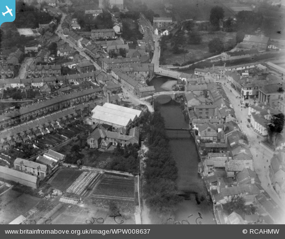
WPW008637 WALES (1923). View of Bridgend showing Newbridge Fields, oblique aerial view. 5"x4" black and white glass plate negative.
© Hawlfraint cyfranwyr OpenStreetMap a thrwyddedwyd gan yr OpenStreetMap Foundation. 2026. Trwyddedir y gartograffeg fel CC BY-SA.
Delweddau cyfagos (28)
WAW006828

WAW006829

WAW006830

WAW006831

WAW006832

WAW006833

WAW039128
. Oblique aerial photograph, 5½\" cut roll film.")
WAW039129
. Oblique aerial photograph, 5½\" cut roll film.")
WAW039130
. Oblique aerial photograph, 5½\" cut roll film.")
WAW039131

WPW008636

WPW008637

WPW008638

WPW008639

WPW008640

WPW029401

WPW029402

WPW029403

WPW029404

WPW029405

WPW029406

WPW029407

WPW029408

WPW029409

WPW029410

WPW029411

WPW038314

WPW038317

Manylion
| Pennawd | [WPW008637] View of Bridgend showing Newbridge Fields, oblique aerial view. 5"x4" black and white glass plate negative. |
| Cyfeirnod | WPW008637 |
| Dyddiad | 1923 |
| Dolen | Coflein Archive Item 6370377 |
| Enw lle | |
| Plwyf | |
| Ardal | |
| Gwlad | WALES |
| Dwyreiniad / Gogleddiad | 290565, 179834 |
| Hydred / Lledred | -3.5769987719446, 51.506345252149 |
| Cyfeirnod Grid Cenedlaethol | SS906798 |
Pinnau

86F |
Monday 24th of November 2014 10:17:28 PM | |
|
86F |
Monday 24th of November 2014 10:16:44 PM | |

Class31 |
Wednesday 18th of September 2013 08:20:03 AM | |
|
86F |
Friday 30th of August 2013 04:41:17 PM | |
|
ricksutton |
Monday 16th of July 2012 06:50:02 PM |
Cyfraniadau Grŵp
Just below the cenotaph and town hall stands what used to be the Wyndham Hotel. There appears to be a large tree growing where "The Ship" used to be. |
Colin Ball |
Wednesday 4th of July 2012 09:16:19 PM |
Newbridge Fields isn`t on this photo. The field at the top of the image is where the Embassy Cinema stood until last year when it was demolished. On the right is the old town hall and cenitaph. The middle bridge is the 14c. bridge that the town was supposedly named after. |
malin |
Tuesday 26th of June 2012 10:09:20 PM |