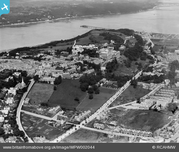
WPW002044 WALES (1920). Distant view of Bangor, oblique aerial view. 5"x4" black and white glass plate negative.
© Hawlfraint cyfranwyr OpenStreetMap a thrwyddedwyd gan yr OpenStreetMap Foundation. 2026. Trwyddedir y gartograffeg fel CC BY-SA.
Delweddau cyfagos (17)
Manylion
| Pennawd | [WPW002044] Distant view of Bangor, oblique aerial view. 5"x4" black and white glass plate negative. |
| Cyfeirnod | WPW002044 |
| Dyddiad | July-1920 |
| Dolen | Coflein Archive Item 6370246 |
| Enw lle | |
| Plwyf | |
| Ardal | |
| Gwlad | WALES |
| Dwyreiniad / Gogleddiad | 258087, 372019 |
| Hydred / Lledred | -4.1260777865694, 53.22594875768 |
| Cyfeirnod Grid Cenedlaethol | SH581720 |
Pinnau

welshman |
Wednesday 11th of July 2012 08:51:29 AM | |

welshman |
Wednesday 11th of July 2012 08:49:40 AM | |

Bwnsan |
Thursday 28th of June 2012 05:53:08 PM | |

JMB |
Tuesday 26th of June 2012 10:45:50 PM |
Cyfraniadau Grŵp
The War Memorial Arch should be visible at the position marked, it was completed in 1923. It can be seen on Image reference WPW045210 along with various science buildings to the left along Deiniol Road. |

JMB |
Tuesday 26th of June 2012 10:47:29 PM |


![[WAW001734] View of Bangor](http://britainfromabove.org.uk/sites/all/libraries/aerofilms-images/public/100x100/WAW/001/WAW001734.jpg)
![[WAW001735] View of Bangor showing military camp on site of St George's Field Playing fields](http://britainfromabove.org.uk/sites/all/libraries/aerofilms-images/public/100x100/WAW/001/WAW001735.jpg)
![[WAW001738] Distant view of Bangor and Menai Straits](http://britainfromabove.org.uk/sites/all/libraries/aerofilms-images/public/100x100/WAW/001/WAW001738.jpg)
![[WAW001739] Distant view of Bangor and Menai Straits](http://britainfromabove.org.uk/sites/all/libraries/aerofilms-images/public/100x100/WAW/001/WAW001739.jpg)
![[WPW002036] View of Bangor showing pier, oblique aerial view. 5"x4" black and white glass plate negative.](http://britainfromabove.org.uk/sites/all/libraries/aerofilms-images/public/100x100/WPW/002/WPW002036.jpg)
![[WPW002038] General view of Bangor showing cathedral. Oblique aerial photograph, 5"x4" BW glass plate.](http://britainfromabove.org.uk/sites/all/libraries/aerofilms-images/public/100x100/WPW/002/WPW002038.jpg)
![[WPW002040] View of Bangor, oblique aerial view. 5"x4" black and white glass plate negative.](http://britainfromabove.org.uk/sites/all/libraries/aerofilms-images/public/100x100/WPW/002/WPW002040.jpg)
![[WPW002042] View of the Menai suspension bridge, Bangor, oblique aerial view. 5"x4" black and white glass plate negative.](http://britainfromabove.org.uk/sites/all/libraries/aerofilms-images/public/100x100/WPW/002/WPW002042.jpg)
![[WPW002043] View of Bangor, oblique aerial view. 5"x4" black and white glass plate negative.](http://britainfromabove.org.uk/sites/all/libraries/aerofilms-images/public/100x100/WPW/002/WPW002043.jpg)
![[WPW002044] Distant view of Bangor, oblique aerial view. 5"x4" black and white glass plate negative.](http://britainfromabove.org.uk/sites/all/libraries/aerofilms-images/public/100x100/WPW/002/WPW002044.jpg)
![[WPW002045] View of the Menai suspension bridge, Bangor, oblique aerial view. 5"x4" black and white glass plate negative.](http://britainfromabove.org.uk/sites/all/libraries/aerofilms-images/public/100x100/WPW/002/WPW002045.jpg)
![[WPW002046] View of Bangor, oblique aerial view. 5"x4" black and white glass plate negative.](http://britainfromabove.org.uk/sites/all/libraries/aerofilms-images/public/100x100/WPW/002/WPW002046.jpg)
![[WPW002047] View of Bangor, oblique aerial view. 5"x4" black and white glass plate negative.](http://britainfromabove.org.uk/sites/all/libraries/aerofilms-images/public/100x100/WPW/002/WPW002047.jpg)
![[WPW045210] View of Bangor, oblique aerial view. 5"x4" black and white glass plate negative.](http://britainfromabove.org.uk/sites/all/libraries/aerofilms-images/public/100x100/WPW/045/WPW045210.jpg)
![[WPW045211] View of Bangor showing harbour, oblique aerial view. 5"x4" black and white glass plate negative.](http://britainfromabove.org.uk/sites/all/libraries/aerofilms-images/public/100x100/WPW/045/WPW045211.jpg)
![[WPW045212] View of Bangor, oblique aerial view. 5"x4" black and white glass plate negative.](http://britainfromabove.org.uk/sites/all/libraries/aerofilms-images/public/100x100/WPW/045/WPW045212.jpg)
![[WPW045213] View of Bangor, oblique aerial view. 5"x4" black and white glass plate negative.](http://britainfromabove.org.uk/sites/all/libraries/aerofilms-images/public/100x100/WPW/045/WPW045213.jpg)