
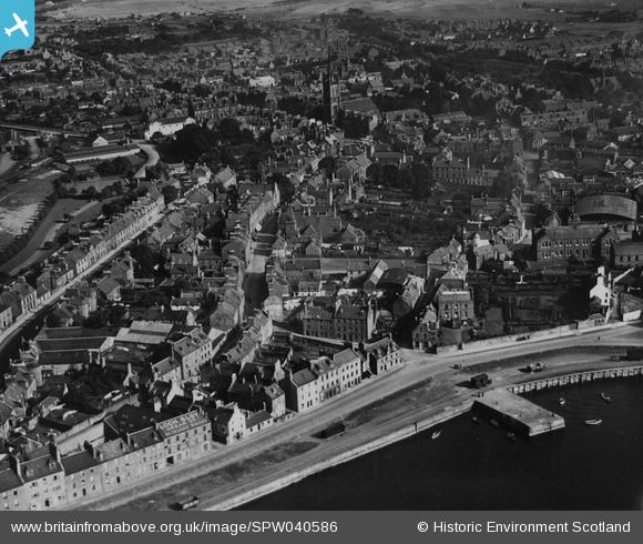
SPW040586 SCOTLAND (1932). Montrose, general view, showing Wharf Street and Castle Street. An oblique aerial photograph taken facing north-east. This image has been produced from a print.
© Hawlfraint cyfranwyr OpenStreetMap a thrwyddedwyd gan yr OpenStreetMap Foundation. 2026. Trwyddedir y gartograffeg fel CC BY-SA.
Delweddau cyfagos (5)
SPW040586

SAW051245

SAW051244

SPW040585

SPW033638

Manylion
| Pennawd | [SPW040586] Montrose, general view, showing Wharf Street and Castle Street. An oblique aerial photograph taken facing north-east. This image has been produced from a print. |
| Cyfeirnod | SPW040586 |
| Dyddiad | 1932 |
| Dolen | NRHE Collection item 1315572 |
| Enw lle | |
| Plwyf | MONTROSE |
| Ardal | ANGUS |
| Gwlad | SCOTLAND |
| Dwyreiniad / Gogleddiad | 371260, 757500 |
| Hydred / Lledred | -2.4694857269847, 56.708446910225 |
| Cyfeirnod Grid Cenedlaethol | NO713575 |
Pinnau

Celurca |
Tuesday 2nd of March 2021 01:23:23 PM | |
|
Celurca |
Tuesday 2nd of March 2021 01:22:11 PM | |
|
Celurca |
Tuesday 2nd of March 2021 01:21:07 PM | |
|
Celurca |
Tuesday 2nd of March 2021 01:19:34 PM | |
|
Celurca |
Tuesday 2nd of March 2021 01:18:25 PM | |
|
Celurca |
Tuesday 2nd of March 2021 01:17:20 PM | |
|
Celurca |
Tuesday 2nd of March 2021 01:16:47 PM | |
|
Celurca |
Tuesday 2nd of March 2021 01:15:46 PM | |
|
Celurca |
Tuesday 2nd of March 2021 01:14:43 PM | |
|
Celurca |
Tuesday 2nd of March 2021 01:14:02 PM | |
|
Celurca |
Tuesday 2nd of March 2021 01:12:55 PM | |
|
nag67 |
Friday 14th of June 2013 11:05:40 PM |