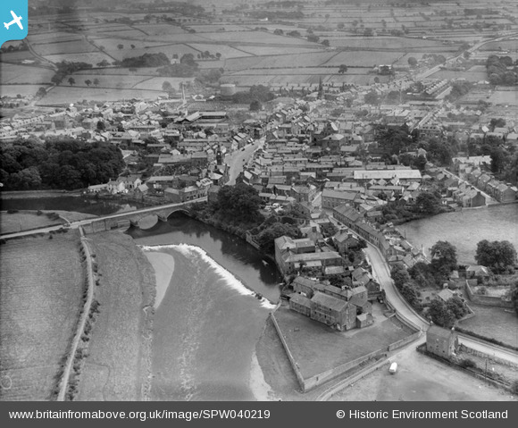
SPW040219 SCOTLAND (1932). Annan, general view, showing Bridge of Annan and Port Street. An oblique aerial photograph taken facing east.
    © Hawlfraint cyfranwyr OpenStreetMap a thrwyddedwyd gan yr OpenStreetMap Foundation. 2025. Trwyddedir y gartograffeg fel CC BY-SA.
  
Delweddau cyfagos (12)
Manylion
| Pennawd | [SPW040219] Annan, general view, showing Bridge of Annan and Port Street. An oblique aerial photograph taken facing east. | 
| Cyfeirnod | SPW040219 | 
| Dyddiad | 1932 | 
| Dolen | NRHE Collection item 1257302 | 
| Enw lle | |
| Plwyf | ANNAN | 
| Ardal | ANNANDALE AND ESKDALE | 
| Gwlad | SCOTLAND | 
| Dwyreiniad / Gogleddiad | 319146, 566524 | 
| Hydred / Lledred | -3.263703279778, 54.986663485951 | 
| Cyfeirnod Grid Cenedlaethol | NY191665 | 
Pinnau
Byddwch y cyntaf i ychwanegu sylw at y ddelwedd hon!
Cyfraniadau Grŵp
| https://drive.google.com/a/cathynewbery.co.uk/uc?id=0B5rW0927v08SMDNobVpfOVhmOGM&export=download |   Borders Project | Wednesday 13th of August 2014 01:44:42 PM | 
|   Borders Project | Wednesday 13th of August 2014 12:30:21 PM | 
 
             
  ![[SPW040219] Annan, general view, showing Bridge of Annan and Port Street.  An oblique aerial photograph taken facing east.](http://britainfromabove.org.uk/sites/all/libraries/aerofilms-images/public/100x100/SPW/040/SPW040219.jpg) 
  
                                          ![[SPW029231] Annan, general view, showing High Street and Bridge of Annan.  An oblique aerial photograph taken facing east.](http://britainfromabove.org.uk/sites/all/libraries/aerofilms-images/public/100x100/SPW/029/SPW029231.jpg) 
 ![[SPW029230] Annan, general view, showing High Street and Bridge of Annan.  An oblique aerial photograph taken facing north.](http://britainfromabove.org.uk/sites/all/libraries/aerofilms-images/public/100x100/SPW/029/SPW029230.jpg) 
 ![[SPW040218] Annan, general view, showing Bridge of Annan and High Street.  An oblique aerial photograph taken facing north-west.](http://britainfromabove.org.uk/sites/all/libraries/aerofilms-images/public/100x100/SPW/040/SPW040218.jpg) 
 ![[SPW029234] Annan, general view, showing Old Parish Church and High Street.  An oblique aerial photograph taken facing north.](http://britainfromabove.org.uk/sites/all/libraries/aerofilms-images/public/100x100/SPW/029/SPW029234.jpg) 
 ![[SAW043379] Annan, general view, showing Bridge of Annan and St John's Road.  An oblique aerial photograph taken facing north.](http://britainfromabove.org.uk/sites/all/libraries/aerofilms-images/public/100x100/SAW/043/SAW043379.jpg) 
 ![[SAW043380] Annan, general view, showing Bridge of Annan and Butts Street.  An oblique aerial photograph taken facing north-east.](http://britainfromabove.org.uk/sites/all/libraries/aerofilms-images/public/100x100/SAW/043/SAW043380.jpg) 
 ![[SPW029235] Annan, general view, showing High Street and Lady Street.  An oblique aerial photograph taken facing north.](http://britainfromabove.org.uk/sites/all/libraries/aerofilms-images/public/100x100/SPW/029/SPW029235.jpg) 
 ![[SPW040215] Annan, general view, showing High Street and Ednam Street.  An oblique aerial photograph taken facing west.](http://britainfromabove.org.uk/sites/all/libraries/aerofilms-images/public/100x100/SPW/040/SPW040215.jpg) 
 ![[SPW029236] Annan, general view, showing High Street and Ednam Street.  An oblique aerial photograph taken facing north.](http://britainfromabove.org.uk/sites/all/libraries/aerofilms-images/public/100x100/SPW/029/SPW029236.jpg) 
 ![[SPW029229] Annan, general view, showing Central Hotel, Station Road and St John's Road.  An oblique aerial photograph taken facing north.](http://britainfromabove.org.uk/sites/all/libraries/aerofilms-images/public/100x100/SPW/029/SPW029229.jpg) 
 ![[SPW040216] Annan, general view, showing Central Hotel, Station Road and St John's Road.  An oblique aerial photograph taken facing north.](http://britainfromabove.org.uk/sites/all/libraries/aerofilms-images/public/100x100/SPW/040/SPW040216.jpg) 
 