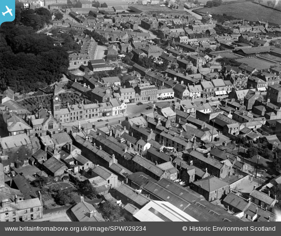
SPW029234 SCOTLAND (1929). Annan, general view, showing Old Parish Church and High Street. An oblique aerial photograph taken facing north.
    © Hawlfraint cyfranwyr OpenStreetMap a thrwyddedwyd gan yr OpenStreetMap Foundation. 2025. Trwyddedir y gartograffeg fel CC BY-SA.
  
Delweddau cyfagos (13)
Manylion
| Pennawd | [SPW029234] Annan, general view, showing Old Parish Church and High Street. An oblique aerial photograph taken facing north. | 
| Cyfeirnod | SPW029234 | 
| Dyddiad | 1929 | 
| Dolen | NRHE Collection item 1256907 | 
| Enw lle | |
| Plwyf | ANNAN | 
| Ardal | ANNANDALE AND ESKDALE | 
| Gwlad | SCOTLAND | 
| Dwyreiniad / Gogleddiad | 319268, 566588 | 
| Hydred / Lledred | -3.2618150432752, 54.987258319356 | 
| Cyfeirnod Grid Cenedlaethol | NY193666 | 
Pinnau
|  9 Carlyles place |   Hardy | Saturday 30th of June 2012 03:40:12 PM | 
 
             
  ![[SPW029234] Annan, general view, showing Old Parish Church and High Street.  An oblique aerial photograph taken facing north.](http://britainfromabove.org.uk/sites/all/libraries/aerofilms-images/public/100x100/SPW/029/SPW029234.jpg) 
  
                                          ![[SAW043379] Annan, general view, showing Bridge of Annan and St John's Road.  An oblique aerial photograph taken facing north.](http://britainfromabove.org.uk/sites/all/libraries/aerofilms-images/public/100x100/SAW/043/SAW043379.jpg) 
 ![[SAW043380] Annan, general view, showing Bridge of Annan and Butts Street.  An oblique aerial photograph taken facing north-east.](http://britainfromabove.org.uk/sites/all/libraries/aerofilms-images/public/100x100/SAW/043/SAW043380.jpg) 
 ![[SPW029235] Annan, general view, showing High Street and Lady Street.  An oblique aerial photograph taken facing north.](http://britainfromabove.org.uk/sites/all/libraries/aerofilms-images/public/100x100/SPW/029/SPW029235.jpg) 
 ![[SPW040218] Annan, general view, showing Bridge of Annan and High Street.  An oblique aerial photograph taken facing north-west.](http://britainfromabove.org.uk/sites/all/libraries/aerofilms-images/public/100x100/SPW/040/SPW040218.jpg) 
 ![[SPW029231] Annan, general view, showing High Street and Bridge of Annan.  An oblique aerial photograph taken facing east.](http://britainfromabove.org.uk/sites/all/libraries/aerofilms-images/public/100x100/SPW/029/SPW029231.jpg) 
 ![[SPW029230] Annan, general view, showing High Street and Bridge of Annan.  An oblique aerial photograph taken facing north.](http://britainfromabove.org.uk/sites/all/libraries/aerofilms-images/public/100x100/SPW/029/SPW029230.jpg) 
 ![[SPW029236] Annan, general view, showing High Street and Ednam Street.  An oblique aerial photograph taken facing north.](http://britainfromabove.org.uk/sites/all/libraries/aerofilms-images/public/100x100/SPW/029/SPW029236.jpg) 
 ![[SPW040215] Annan, general view, showing High Street and Ednam Street.  An oblique aerial photograph taken facing west.](http://britainfromabove.org.uk/sites/all/libraries/aerofilms-images/public/100x100/SPW/040/SPW040215.jpg) 
 ![[SPW040219] Annan, general view, showing Bridge of Annan and Port Street.  An oblique aerial photograph taken facing east.](http://britainfromabove.org.uk/sites/all/libraries/aerofilms-images/public/100x100/SPW/040/SPW040219.jpg) 
 ![[SPW029232] Annan, general view, showing High Street and Murray Street.  An oblique aerial photograph taken facing north-west.](http://britainfromabove.org.uk/sites/all/libraries/aerofilms-images/public/100x100/SPW/029/SPW029232.jpg) 
 ![[SAR019951] General View Annan, Dumfries-Shire, Scotland. An oblique aerial photograph taken facing South/East. This image was marked by AeroPictorial Ltd for photo editing.](http://britainfromabove.org.uk/sites/all/libraries/aerofilms-images/public/100x100/SAR/019/SAR019951.jpg) 
 ![[SAR019952] General View Annan, Dumfries-Shire, Scotland. An oblique aerial photograph taken facing North/West. This image was marked by AeroPictorial Ltd for photo editing.](http://britainfromabove.org.uk/sites/all/libraries/aerofilms-images/public/100x100/SAR/019/SAR019952.jpg)