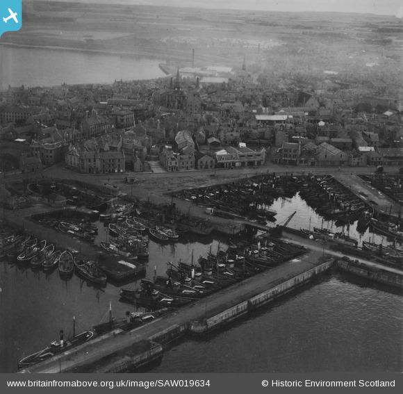
SAW019634 SCOTLAND (1948). Peterhead, general view, showing Port Henry and North Harbours and Town House, Broad Street. An oblique aerial photograph taken facing west. This image has been produced from a print.
    © Hawlfraint cyfranwyr OpenStreetMap a thrwyddedwyd gan yr OpenStreetMap Foundation. 2025. Trwyddedir y gartograffeg fel CC BY-SA.
  
Delweddau cyfagos (11)
Manylion
| Pennawd | [SAW019634] Peterhead, general view, showing Port Henry and North Harbours and Town House, Broad Street. An oblique aerial photograph taken facing west. This image has been produced from a print. | 
| Cyfeirnod | SAW019634 | 
| Dyddiad | 1948 | 
| Dolen | NRHE Collection item 1315007 | 
| Enw lle | |
| Plwyf | PETERHEAD | 
| Ardal | BANFF AND BUCHAN | 
| Gwlad | SCOTLAND | 
| Dwyreiniad / Gogleddiad | 413610, 846130 | 
| Hydred / Lledred | -1.7728491413634, 57.505391360535 | 
| Cyfeirnod Grid Cenedlaethol | NK136461 | 
Pinnau
Byddwch y cyntaf i ychwanegu sylw at y ddelwedd hon!
 
             
  ![[SAW019634] Peterhead, general view, showing Port Henry and North Harbours and Town House, Broad Street.  An oblique aerial photograph taken facing west.  This image has been produced from a print.](http://britainfromabove.org.uk/sites/all/libraries/aerofilms-images/public/100x100/SAW/019/SAW019634.jpg) 
  
                                          ![[SAW014820] Peterhead Harbour.  An oblique aerial photograph taken facing south-east.](http://britainfromabove.org.uk/sites/all/libraries/aerofilms-images/public/100x100/SAW/014/SAW014820.jpg) 
 ![[SAW014821] Peterhead Harbour.  An oblique aerial photograph taken facing east.](http://britainfromabove.org.uk/sites/all/libraries/aerofilms-images/public/100x100/SAW/014/SAW014821.jpg) 
 ![[SAW014824] Port Henry Harbour, Peterhead.  An oblique aerial photograph taken facing north-east.  This image has been produced from a print.](http://britainfromabove.org.uk/sites/all/libraries/aerofilms-images/public/100x100/SAW/014/SAW014824.jpg) 
 ![[SAW019631] Peterhead, general view, showing Port Henry Harbour and Peterhead Bay.  An oblique aerial photograph taken facing west.  This image has been produced from a print.](http://britainfromabove.org.uk/sites/all/libraries/aerofilms-images/public/100x100/SAW/019/SAW019631.jpg) 
 ![[SAW014823] Port Henry Harbour, Peterhead.  An oblique aerial photograph taken facing east.  This image has been produced from a print.](http://britainfromabove.org.uk/sites/all/libraries/aerofilms-images/public/100x100/SAW/014/SAW014823.jpg) 
 ![[SAW019635] Peterhead Harbour.  An oblique aerial photograph taken facing south.  This image has been produced from a print.](http://britainfromabove.org.uk/sites/all/libraries/aerofilms-images/public/100x100/SAW/019/SAW019635.jpg) 
 ![[SAW014819] Peterhead Harbour.  An oblique aerial photograph taken facing south.](http://britainfromabove.org.uk/sites/all/libraries/aerofilms-images/public/100x100/SAW/014/SAW014819.jpg) 
 ![[SAW014822] Peterhead, general view, showing Peterhead Harbour and Jamaica Street.  An oblique aerial photograph taken facing north.  This image has been produced from a damaged negative.](http://britainfromabove.org.uk/sites/all/libraries/aerofilms-images/public/100x100/SAW/014/SAW014822.jpg) 
 ![[SAW014825] South and North Harbours, Peterhead.  An oblique aerial photograph taken facing north.  This image has been produced from a print.](http://britainfromabove.org.uk/sites/all/libraries/aerofilms-images/public/100x100/SAW/014/SAW014825.jpg) 
 ![[SAW019632] North and South Harbours, Peterhead.  An oblique aerial photograph taken facing north-east.  This image has been produced from a print.](http://britainfromabove.org.uk/sites/all/libraries/aerofilms-images/public/100x100/SAW/019/SAW019632.jpg)