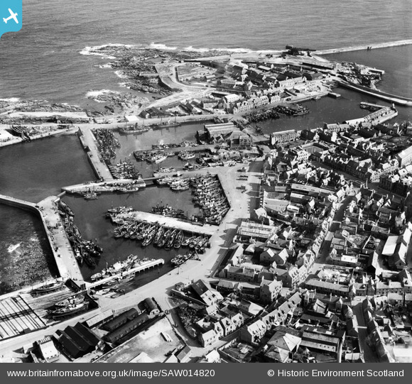
SAW014820 SCOTLAND (1948). Peterhead Harbour. An oblique aerial photograph taken facing south-east.
    © Hawlfraint cyfranwyr OpenStreetMap a thrwyddedwyd gan yr OpenStreetMap Foundation. 2025. Trwyddedir y gartograffeg fel CC BY-SA.
  
Delweddau cyfagos (8)
Manylion
| Pennawd | [SAW014820] Peterhead Harbour. An oblique aerial photograph taken facing south-east. | 
| Cyfeirnod | SAW014820 | 
| Dyddiad | 1948 | 
| Dolen | NRHE Collection item 1268922 | 
| Enw lle | |
| Plwyf | MARITIME - ABERDEENSHIRE | 
| Ardal | MARITIME | 
| Gwlad | SCOTLAND | 
| Dwyreiniad / Gogleddiad | 413600, 846200 | 
| Hydred / Lledred | -1.7730121360208, 57.506020505862 | 
| Cyfeirnod Grid Cenedlaethol | NK136462 | 
Pinnau
|  Longate |   David960 | Monday 5th of June 2023 12:00:02 PM | 
|  PILLBOX: e32461 |   Matt Aldred edob.mattaldred.com | Thursday 4th of March 2021 03:18:19 PM | 
|  2ndWW ex-navy MGB.  British Powerboat? |   redmist | Saturday 30th of January 2021 10:31:30 AM | 
|  2ndWW pillbox. |   redmist | Saturday 30th of January 2021 09:56:47 AM | 
|  Nissen huts. |   redmist | Saturday 30th of January 2021 09:51:33 AM | 
|  ? Ex-Royal Navy steam gun boat? |   redmist | Saturday 30th of January 2021 09:50:31 AM | 
|  Hammerhead crane |   MB | Friday 21st of September 2012 12:20:34 PM | 
|  Hammerhead crane |   MB | Friday 21st of September 2012 12:20:06 PM | 
|  Horse and cart |   MB | Friday 21st of September 2012 12:17:41 PM | 
 
             
  ![[SAW014820] Peterhead Harbour.  An oblique aerial photograph taken facing south-east.](http://britainfromabove.org.uk/sites/all/libraries/aerofilms-images/public/100x100/SAW/014/SAW014820.jpg) 
  
                                          ![[SAW014821] Peterhead Harbour.  An oblique aerial photograph taken facing east.](http://britainfromabove.org.uk/sites/all/libraries/aerofilms-images/public/100x100/SAW/014/SAW014821.jpg) 
 ![[SAW014824] Port Henry Harbour, Peterhead.  An oblique aerial photograph taken facing north-east.  This image has been produced from a print.](http://britainfromabove.org.uk/sites/all/libraries/aerofilms-images/public/100x100/SAW/014/SAW014824.jpg) 
 ![[SAW019631] Peterhead, general view, showing Port Henry Harbour and Peterhead Bay.  An oblique aerial photograph taken facing west.  This image has been produced from a print.](http://britainfromabove.org.uk/sites/all/libraries/aerofilms-images/public/100x100/SAW/019/SAW019631.jpg) 
 ![[SAW019634] Peterhead, general view, showing Port Henry and North Harbours and Town House, Broad Street.  An oblique aerial photograph taken facing west.  This image has been produced from a print.](http://britainfromabove.org.uk/sites/all/libraries/aerofilms-images/public/100x100/SAW/019/SAW019634.jpg) 
 ![[SAW014823] Port Henry Harbour, Peterhead.  An oblique aerial photograph taken facing east.  This image has been produced from a print.](http://britainfromabove.org.uk/sites/all/libraries/aerofilms-images/public/100x100/SAW/014/SAW014823.jpg) 
 ![[SAW019635] Peterhead Harbour.  An oblique aerial photograph taken facing south.  This image has been produced from a print.](http://britainfromabove.org.uk/sites/all/libraries/aerofilms-images/public/100x100/SAW/019/SAW019635.jpg) 
 ![[SAW014819] Peterhead Harbour.  An oblique aerial photograph taken facing south.](http://britainfromabove.org.uk/sites/all/libraries/aerofilms-images/public/100x100/SAW/014/SAW014819.jpg)