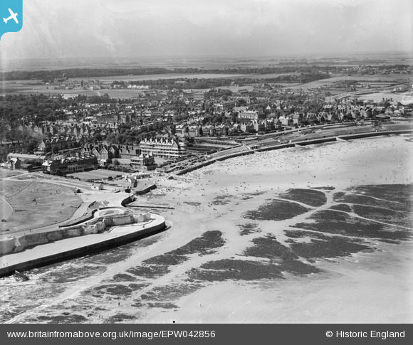
EPW042856 ENGLAND (1933). St Mildred's Bay and environs, Westgate-on-Sea, from the north-east, 1933
© Hawlfraint cyfranwyr OpenStreetMap a thrwyddedwyd gan yr OpenStreetMap Foundation. 2026. Trwyddedir y gartograffeg fel CC BY-SA.
Delweddau cyfagos (9)
Manylion
| Pennawd | [EPW042856] St Mildred's Bay and environs, Westgate-on-Sea, from the north-east, 1933 |
| Cyfeirnod | EPW042856 |
| Dyddiad | August-1933 |
| Dolen | |
| Enw lle | WESTGATE-ON-SEA |
| Plwyf | |
| Ardal | |
| Gwlad | ENGLAND |
| Dwyreiniad / Gogleddiad | 632842, 170507 |
| Hydred / Lledred | 1.3468022199471, 51.385265046963 |
| Cyfeirnod Grid Cenedlaethol | TR328705 |
Pinnau
Byddwch y cyntaf i ychwanegu sylw at y ddelwedd hon!


![[EPW042856] St Mildred's Bay and environs, Westgate-on-Sea, from the north-east, 1933](http://britainfromabove.org.uk/sites/all/libraries/aerofilms-images/public/100x100/EPW/042/EPW042856.jpg)
![[EPW035479] St Mildred's Bay and environs, Westgate-on-Sea, from the north-east, 1931](http://britainfromabove.org.uk/sites/all/libraries/aerofilms-images/public/100x100/EPW/035/EPW035479.jpg)
![[EPW009157] The Esplanade and St Mildred's Bay, Westgate-on-Sea, 1923](http://britainfromabove.org.uk/sites/all/libraries/aerofilms-images/public/100x100/EPW/009/EPW009157.jpg)
![[EPW054077] St Mildred's Bay, St Mildred's Hotel and environs, Westgate-on-Sea, from the north-west, 1937](http://britainfromabove.org.uk/sites/all/libraries/aerofilms-images/public/100x100/EPW/054/EPW054077.jpg)
![[EPW009160] The Esplanade and St Mildred's Bay, Westgate-on-Sea, 1923](http://britainfromabove.org.uk/sites/all/libraries/aerofilms-images/public/100x100/EPW/009/EPW009160.jpg)
![[EPW009159] The Esplanade and St Mildred's Bay, Westgate-on-Sea, 1923](http://britainfromabove.org.uk/sites/all/libraries/aerofilms-images/public/100x100/EPW/009/EPW009159.jpg)
![[EPW009156] The Esplanade and St Mildred's Bay, Westgate-on-Sea, 1923](http://britainfromabove.org.uk/sites/all/libraries/aerofilms-images/public/100x100/EPW/009/EPW009156.jpg)
![[EPW009158] The Esplanade and St Mildred's Bay, Westgate-on-Sea, 1923](http://britainfromabove.org.uk/sites/all/libraries/aerofilms-images/public/100x100/EPW/009/EPW009158.jpg)
![[EPW042855] St Mildred's Bay and environs, Westgate-on-Sea, from the north-east, 1933](http://britainfromabove.org.uk/sites/all/libraries/aerofilms-images/public/100x100/EPW/042/EPW042855.jpg)