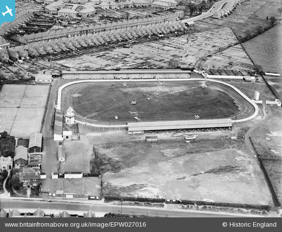
EPW027016 ENGLAND (1929). The Greyhound Stadium, King's Heath, 1929
    © Hawlfraint cyfranwyr OpenStreetMap a thrwyddedwyd gan yr OpenStreetMap Foundation. 2025. Trwyddedir y gartograffeg fel CC BY-SA.
  
Delweddau cyfagos (13)
Manylion
| Pennawd | [EPW027016] The Greyhound Stadium, King's Heath, 1929 | 
| Cyfeirnod | EPW027016 | 
| Dyddiad | May-1929 | 
| Dolen | |
| Enw lle | KING'S HEATH | 
| Plwyf | |
| Ardal | |
| Gwlad | ENGLAND | 
| Dwyreiniad / Gogleddiad | 407591, 280234 | 
| Hydred / Lledred | -1.8883679344576, 52.419669197987 | 
| Cyfeirnod Grid Cenedlaethol | SP076802 | 
Pinnau
Byddwch y cyntaf i ychwanegu sylw at y ddelwedd hon!
Cyfraniadau Grŵp
| Interesting that in its early form the track had four distinct corners with short straights at each end. Later views show a true oval circuit where turn one flows directly into turn two, and three into four. The South Stand burned down in 1933 and had to be replaced. |   gBr | Monday 30th of November 2015 10:24:51 PM | 
 
             
  ![[EPW027016] The Greyhound Stadium, King's Heath, 1929](http://britainfromabove.org.uk/sites/all/libraries/aerofilms-images/public/100x100/EPW/027/EPW027016.jpg) 
  
                                          ![[EAW032593] Kings Heath Greyhound Track, Brandwood End, 1950. This image was marked by Aerofilms Ltd for photo editing.](http://britainfromabove.org.uk/sites/all/libraries/aerofilms-images/public/100x100/EAW/032/EAW032593.jpg) 
 ![[EAW032588] Kings Heath Greyhound Track, Brandwood End, 1950](http://britainfromabove.org.uk/sites/all/libraries/aerofilms-images/public/100x100/EAW/032/EAW032588.jpg) 
 ![[EAW032586] Kings Heath Greyhound Track, Brandwood End, 1950](http://britainfromabove.org.uk/sites/all/libraries/aerofilms-images/public/100x100/EAW/032/EAW032586.jpg) 
 ![[EAW032590] Kings Heath Greyhound Track and environs, Brandwood End, 1950. This image was marked by Aerofilms Ltd for photo editing.](http://britainfromabove.org.uk/sites/all/libraries/aerofilms-images/public/100x100/EAW/032/EAW032590.jpg) 
 ![[EAW032589] Kings Heath Greyhound Track and Alcester Road South, Brandwood End, 1950](http://britainfromabove.org.uk/sites/all/libraries/aerofilms-images/public/100x100/EAW/032/EAW032589.jpg) 
 ![[EAW032587] Kings Heath Greyhound Track and May Lane, Brandwood End, 1950. This image was marked by Aerofilms Ltd for photo editing.](http://britainfromabove.org.uk/sites/all/libraries/aerofilms-images/public/100x100/EAW/032/EAW032587.jpg) 
 ![[EAW032595] Kings Heath Greyhound Track and environs, Brandwood End, 1950](http://britainfromabove.org.uk/sites/all/libraries/aerofilms-images/public/100x100/EAW/032/EAW032595.jpg) 
 ![[EAW032591] Kings Heath Greyhound Track, Brandwood End, 1950](http://britainfromabove.org.uk/sites/all/libraries/aerofilms-images/public/100x100/EAW/032/EAW032591.jpg) 
 ![[EAW032594] Kings Heath Greyhound Track and environs, Brandwood End, 1950](http://britainfromabove.org.uk/sites/all/libraries/aerofilms-images/public/100x100/EAW/032/EAW032594.jpg) 
 ![[EAW032592] Kings Heath Greyhound Track and May Lane, Brandwood End, 1950](http://britainfromabove.org.uk/sites/all/libraries/aerofilms-images/public/100x100/EAW/032/EAW032592.jpg) 
 ![[EAW032596] Kings Heath Greyhound Track and the Brandwood End Cemetery, Brandwood End, 1950](http://britainfromabove.org.uk/sites/all/libraries/aerofilms-images/public/100x100/EAW/032/EAW032596.jpg) 
 ![[EAW032597] Kings Heath Greyhound Track and environs, Brandwood End, 1950](http://britainfromabove.org.uk/sites/all/libraries/aerofilms-images/public/100x100/EAW/032/EAW032597.jpg)