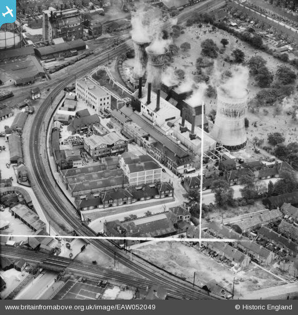
EAW052049 ENGLAND (1953). The Osmond and Sons Ltd Moss Road Works alongside the Moss Road Power Station, Grimsby, 1953. This image was marked by Aerofilms Ltd for photo editing.
© Hawlfraint cyfranwyr OpenStreetMap a thrwyddedwyd gan yr OpenStreetMap Foundation. 2026. Trwyddedir y gartograffeg fel CC BY-SA.
Delweddau cyfagos (14)
Manylion
| Pennawd | [EAW052049] The Osmond and Sons Ltd Moss Road Works alongside the Moss Road Power Station, Grimsby, 1953. This image was marked by Aerofilms Ltd for photo editing. |
| Cyfeirnod | EAW052049 |
| Dyddiad | 7-September-1953 |
| Dolen | |
| Enw lle | GRIMSBY |
| Plwyf | |
| Ardal | |
| Gwlad | ENGLAND |
| Dwyreiniad / Gogleddiad | 527151, 409086 |
| Hydred / Lledred | -0.080001949682671, 53.562719941311 |
| Cyfeirnod Grid Cenedlaethol | TA272091 |
Pinnau

Class31 |
Tuesday 10th of May 2016 11:01:26 PM |


![[EAW052049] The Osmond and Sons Ltd Moss Road Works alongside the Moss Road Power Station, Grimsby, 1953. This image was marked by Aerofilms Ltd for photo editing.](http://britainfromabove.org.uk/sites/all/libraries/aerofilms-images/public/100x100/EAW/052/EAW052049.jpg)
![[EAW052052] The Osmond and Sons Ltd Moss Road Works alongside the Moss Road Power Station, Grimsby, 1953. This image was marked by Aerofilms Ltd for photo editing.](http://britainfromabove.org.uk/sites/all/libraries/aerofilms-images/public/100x100/EAW/052/EAW052052.jpg)
![[EAW052054] The Osmond and Sons Ltd Moss Road Works alongside the Moss Road Power Station, Grimsby, 1953. This image was marked by Aerofilms Ltd for photo editing.](http://britainfromabove.org.uk/sites/all/libraries/aerofilms-images/public/100x100/EAW/052/EAW052054.jpg)
![[EAW052051] The Osmond and Sons Ltd Moss Road Works alongside the Moss Road Power Station, Grimsby, 1953. This image was marked by Aerofilms Ltd for photo editing.](http://britainfromabove.org.uk/sites/all/libraries/aerofilms-images/public/100x100/EAW/052/EAW052051.jpg)
![[EAW052053] The Osmond and Sons Ltd Moss Road Works, Grimsby, 1953. This image was marked by Aerofilms Ltd for photo editing.](http://britainfromabove.org.uk/sites/all/libraries/aerofilms-images/public/100x100/EAW/052/EAW052053.jpg)
![[EPW042804] The Corporation Yard, Osmond and Sons Standard Chemical Works and environs, Grimsby, 1933](http://britainfromabove.org.uk/sites/all/libraries/aerofilms-images/public/100x100/EPW/042/EPW042804.jpg)
![[EAW052050] The Osmond and Sons Ltd Moss Road Works, Grimsby, 1953. This image was marked by Aerofilms Ltd for photo editing.](http://britainfromabove.org.uk/sites/all/libraries/aerofilms-images/public/100x100/EAW/052/EAW052050.jpg)
![[EPW053392] Grimsby Gas Works, the London and North Eastern Railway Line, Doughty Road Old Cemetery and environs, Grimsby, 1937](http://britainfromabove.org.uk/sites/all/libraries/aerofilms-images/public/100x100/EPW/053/EPW053392.jpg)
![[EPW042069] Grimsby Gas Works and environs, Grimsby, 1933](http://britainfromabove.org.uk/sites/all/libraries/aerofilms-images/public/100x100/EPW/042/EPW042069.jpg)
![[EPW042068] Grimsby Gas Works and environs, Grimsby, 1933](http://britainfromabove.org.uk/sites/all/libraries/aerofilms-images/public/100x100/EPW/042/EPW042068.jpg)
![[EPW042066] Grimsby Gas Works, Sheepfold Street and environs, Grimsby, 1933](http://britainfromabove.org.uk/sites/all/libraries/aerofilms-images/public/100x100/EPW/042/EPW042066.jpg)
![[EPW042067] Grimsby Gas Works, Sheepfold Street, Willingholme Street and environs, Grimsby, 1933](http://britainfromabove.org.uk/sites/all/libraries/aerofilms-images/public/100x100/EPW/042/EPW042067.jpg)
![[EPW042071] Grimsby Gas Works and environs, Grimsby, 1933](http://britainfromabove.org.uk/sites/all/libraries/aerofilms-images/public/100x100/EPW/042/EPW042071.jpg)
![[EPW042070] Grimsby Gas Works and the town, Grimsby, from the south, 1933](http://britainfromabove.org.uk/sites/all/libraries/aerofilms-images/public/100x100/EPW/042/EPW042070.jpg)