
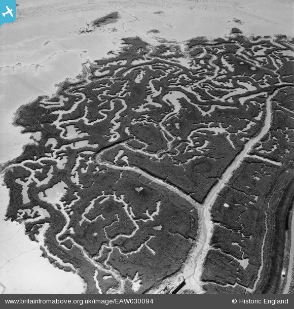
EAW030094 ENGLAND (1950). Part of Stoke Saltings near Stoke Creek Crossing, Stoke, 1950
© Hawlfraint cyfranwyr OpenStreetMap a thrwyddedwyd gan yr OpenStreetMap Foundation. 2025. Trwyddedir y gartograffeg fel CC BY-SA.
Delweddau cyfagos (3)
EAW030094

EAW030093

EAW030100

Manylion
| Pennawd | [EAW030094] Part of Stoke Saltings near Stoke Creek Crossing, Stoke, 1950 |
| Cyfeirnod | EAW030094 |
| Dyddiad | 5-June-1950 |
| Dolen | |
| Enw lle | STOKE |
| Plwyf | STOKE |
| Ardal | |
| Gwlad | ENGLAND |
| Dwyreiniad / Gogleddiad | 582754, 174453 |
| Hydred / Lledred | 0.62981182371464, 51.439056568825 |
| Cyfeirnod Grid Cenedlaethol | TQ828745 |
Pinnau

Cyfraniadau Grŵp
Thanks for the details! We'll update the catalogue and post the new location data here in due course. Yours, Katy Britain from Above Cataloguing Team Leader |
Katy Whitaker |
Friday 27th of June 2014 04:25:16 PM |
I agree with Dave Brunt that this is Stoke Creek near Allhallows. We are looking broadly south. The inlets match those on present day OS mapping. |

Class31 |
Tuesday 6th of May 2014 08:14:32 AM |