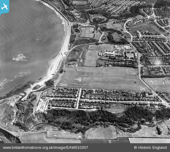
EAW010307 ENGLAND (1947). Scholes Park Road, North Sands and environs, Scarborough, 1947
    © Hawlfraint cyfranwyr OpenStreetMap a thrwyddedwyd gan yr OpenStreetMap Foundation. 2025. Trwyddedir y gartograffeg fel CC BY-SA.
  
Manylion
| Pennawd | [EAW010307] Scholes Park Road, North Sands and environs, Scarborough, 1947 | 
| Cyfeirnod | EAW010307 | 
| Dyddiad | 25-August-1947 | 
| Dolen | |
| Enw lle | SCARBOROUGH | 
| Plwyf | |
| Ardal | |
| Gwlad | ENGLAND | 
| Dwyreiniad / Gogleddiad | 503352, 490486 | 
| Hydred / Lledred | -0.4116653371192, 54.299360063133 | 
| Cyfeirnod Grid Cenedlaethol | TA034905 | 
Pinnau
|  Scalby Beck rifle butts.  Not the ideal situation for such an arrangement, I wouldn't have thought, as the topography of the site is all over the place. |   The Laird | Tuesday 19th of April 2022 12:00:54 AM | 
|  Location of Scholes Park Cliff, built a decade after this image was taken. |   Mart2164 | Tuesday 17th of August 2021 11:46:23 PM | 
|  Burniston Barracks |   The Laird | Tuesday 2nd of June 2015 05:08:50 PM | 
 
             
  ![[EAW010307] Scholes Park Road, North Sands and environs, Scarborough, 1947](http://britainfromabove.org.uk/sites/all/libraries/aerofilms-images/public/100x100/EAW/010/EAW010307.jpg) 
  
                                          ![[EAW010302] Scholes Park Road, North Sands and environs, Scarborough, 1947](http://britainfromabove.org.uk/sites/all/libraries/aerofilms-images/public/100x100/EAW/010/EAW010302.jpg) 
 ![[EAW010301] Scholes Park Road, North Sands and environs, Scarborough, 1947](http://britainfromabove.org.uk/sites/all/libraries/aerofilms-images/public/100x100/EAW/010/EAW010301.jpg) 
 ![[EAW010308] North Sands and the town, Scarborough, 1947](http://britainfromabove.org.uk/sites/all/libraries/aerofilms-images/public/100x100/EAW/010/EAW010308.jpg)