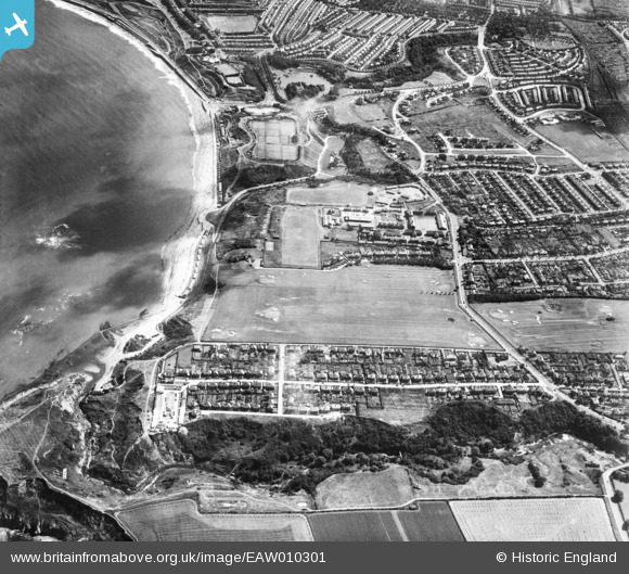
EAW010301 ENGLAND (1947). Scholes Park Road, North Sands and environs, Scarborough, 1947
    © Hawlfraint cyfranwyr OpenStreetMap a thrwyddedwyd gan yr OpenStreetMap Foundation. 2025. Trwyddedir y gartograffeg fel CC BY-SA.
  
Manylion
| Pennawd | [EAW010301] Scholes Park Road, North Sands and environs, Scarborough, 1947 | 
| Cyfeirnod | EAW010301 | 
| Dyddiad | 25-August-1947 | 
| Dolen | |
| Enw lle | SCARBOROUGH | 
| Plwyf | |
| Ardal | |
| Gwlad | ENGLAND | 
| Dwyreiniad / Gogleddiad | 503318, 490438 | 
| Hydred / Lledred | -0.41220423210499, 54.29893567006 | 
| Cyfeirnod Grid Cenedlaethol | TA033904 | 
Pinnau
|  Burniston Barracks |   The Laird | Tuesday 2nd of June 2015 05:06:21 PM | 
 
             
  ![[EAW010301] Scholes Park Road, North Sands and environs, Scarborough, 1947](http://britainfromabove.org.uk/sites/all/libraries/aerofilms-images/public/100x100/EAW/010/EAW010301.jpg) 
  
                                          ![[EAW010307] Scholes Park Road, North Sands and environs, Scarborough, 1947](http://britainfromabove.org.uk/sites/all/libraries/aerofilms-images/public/100x100/EAW/010/EAW010307.jpg) 
 ![[EAW010302] Scholes Park Road, North Sands and environs, Scarborough, 1947](http://britainfromabove.org.uk/sites/all/libraries/aerofilms-images/public/100x100/EAW/010/EAW010302.jpg) 
 ![[EAW010308] North Sands and the town, Scarborough, 1947](http://britainfromabove.org.uk/sites/all/libraries/aerofilms-images/public/100x100/EAW/010/EAW010308.jpg)