
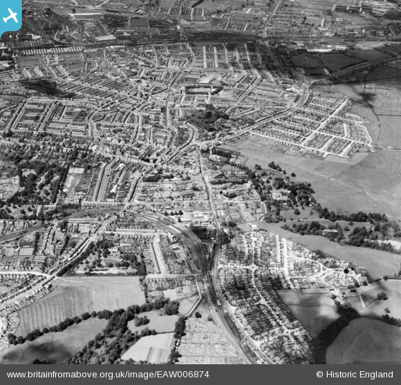
EAW006874 ENGLAND (1947). Old Town and environs, Swindon, from the south, 1947
© Hawlfraint cyfranwyr OpenStreetMap a thrwyddedwyd gan yr OpenStreetMap Foundation. 2026. Trwyddedir y gartograffeg fel CC BY-SA.
Delweddau cyfagos (5)
EAW006874

EPW010118

EPW059049

EAW006875

EPW010117

Manylion
| Pennawd | [EAW006874] Old Town and environs, Swindon, from the south, 1947 |
| Cyfeirnod | EAW006874 |
| Dyddiad | 10-June-1947 |
| Dolen | |
| Enw lle | SWINDON |
| Plwyf | |
| Ardal | |
| Gwlad | ENGLAND |
| Dwyreiniad / Gogleddiad | 415812, 183436 |
| Hydred / Lledred | -1.7719359710118, 51.549115447716 |
| Cyfeirnod Grid Cenedlaethol | SU158834 |
Pinnau

NottmJas |
Friday 3rd of April 2026 10:43:19 PM | |
|
gerry-r |
Sunday 22nd of September 2024 03:41:50 PM | |
|
gerry-r |
Sunday 22nd of September 2024 03:39:31 PM | |
|
gerry-r |
Sunday 22nd of September 2024 03:38:28 PM | |
|
gerry-r |
Sunday 22nd of September 2024 03:36:56 PM | |
|
gerry-r |
Sunday 22nd of September 2024 03:35:44 PM | |
|
gerry-r |
Sunday 22nd of September 2024 10:49:10 AM | |
|
gerry-r |
Sunday 22nd of September 2024 10:47:30 AM | |
|
gerry-r |
Sunday 22nd of September 2024 10:45:24 AM | |
|
gerry-r |
Sunday 22nd of September 2024 10:44:20 AM | |
|
Gary |
Friday 30th of August 2024 06:59:00 PM | |
|
Gary |
Friday 30th of August 2024 06:57:51 PM | |
|
Gary |
Friday 30th of August 2024 06:50:32 PM | |
|
Gary |
Friday 30th of August 2024 06:48:05 PM | |
|
Gary |
Friday 30th of August 2024 06:47:41 PM | |
|
Gary |
Friday 30th of August 2024 06:47:03 PM | |
|
Gary |
Friday 30th of August 2024 06:46:09 PM | |
|
NottmJas |
Saturday 16th of September 2023 11:37:06 PM | |
|
NottmJas |
Saturday 16th of September 2023 11:13:03 PM | |
Generally known as the County Ground Extension |
gerry-r |
Sunday 22nd of September 2024 10:41:58 AM |
|
NottmJas |
Saturday 16th of September 2023 11:12:37 PM | |
|
NottmJas |
Saturday 16th of September 2023 11:12:01 PM | |
|
NottmJas |
Saturday 16th of September 2023 11:11:28 PM | |
|
NottmJas |
Saturday 16th of September 2023 11:07:39 PM | |
|
NottmJas |
Saturday 16th of September 2023 11:05:58 PM | |
|
NottmJas |
Saturday 16th of September 2023 10:45:39 PM | |
|
NottmJas |
Saturday 16th of September 2023 10:44:47 PM | |
|
NottmJas |
Saturday 16th of September 2023 10:40:28 PM | |
|
NottmJas |
Saturday 16th of September 2023 10:38:47 PM | |
|
NottmJas |
Saturday 16th of September 2023 10:38:23 PM | |
|
NottmJas |
Saturday 16th of September 2023 10:37:35 PM | |
|
NottmJas |
Saturday 16th of September 2023 10:36:42 PM | |
|
Copseman |
Saturday 3rd of October 2020 09:20:41 PM | |
|
John |
Wednesday 29th of April 2020 04:05:19 PM | |

Class31 |
Tuesday 14th of January 2014 10:40:29 AM | |
|
Class31 |
Tuesday 14th of January 2014 10:40:05 AM | |
|
Class31 |
Tuesday 14th of January 2014 10:38:28 AM | |
|
Class31 |
Tuesday 14th of January 2014 10:38:08 AM | |
|
Class31 |
Tuesday 14th of January 2014 10:37:42 AM | |
|
Class31 |
Tuesday 14th of January 2014 10:26:44 AM |