
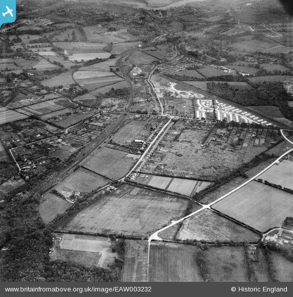
EAW003232 ENGLAND (1946). Hill Park, construction of prefabricated housing around Stow Crescent and environs, Fareham, 1946
© Hawlfraint cyfranwyr OpenStreetMap a thrwyddedwyd gan yr OpenStreetMap Foundation. 2026. Trwyddedir y gartograffeg fel CC BY-SA.
Delweddau cyfagos (4)
EAW003232

EAW003235

EAW003237

EAW003234

Manylion
| Pennawd | [EAW003232] Hill Park, construction of prefabricated housing around Stow Crescent and environs, Fareham, 1946 |
| Cyfeirnod | EAW003232 |
| Dyddiad | 25-October-1946 |
| Dolen | |
| Enw lle | FAREHAM |
| Plwyf | |
| Ardal | |
| Gwlad | ENGLAND |
| Dwyreiniad / Gogleddiad | 455618, 107254 |
| Hydred / Lledred | -1.2096461242351, 50.861559581802 |
| Cyfeirnod Grid Cenedlaethol | SU556073 |
Pinnau

ianhenden |
Saturday 15th of June 2024 03:53:34 PM | |
|
ianhenden |
Sunday 15th of October 2023 04:05:59 PM | |
|
ianhenden |
Sunday 15th of October 2023 04:04:57 PM | |
|
ianhenden |
Sunday 15th of October 2023 04:04:27 PM | |
|
ianhenden |
Sunday 15th of October 2023 04:03:44 PM | |
|
ianhenden |
Sunday 15th of October 2023 03:59:38 PM | |
|
ianhenden |
Sunday 15th of October 2023 03:58:17 PM | |
|
Josharpr |
Sunday 9th of May 2021 07:12:13 PM | |
|
Josharpr |
Wednesday 1st of April 2020 11:38:48 PM | |
|
MikePilot&Navigator |
Monday 17th of September 2018 07:59:56 PM | |
|
MikePilot&Navigator |
Sunday 21st of September 2014 09:40:28 PM | |
|
MikePilot&Navigator |
Sunday 21st of September 2014 09:39:05 PM | |
|
MikePilot&Navigator |
Sunday 21st of September 2014 09:37:50 PM | |
|
MikePilot&Navigator |
Sunday 21st of September 2014 09:37:11 PM | |
|
MikePilot&Navigator |
Sunday 21st of September 2014 09:36:27 PM | |
|
MikePilot&Navigator |
Sunday 21st of September 2014 09:33:54 PM | |
|
MikePilot&Navigator |
Sunday 21st of September 2014 09:32:40 PM | |
|
MikePilot&Navigator |
Sunday 21st of September 2014 08:47:32 PM | |
|
MikePilot&Navigator |
Sunday 21st of September 2014 07:47:36 PM | |
|
flubber |
Saturday 10th of May 2014 08:58:24 PM | |
|
sue tarling |
Wednesday 28th of August 2013 09:23:55 PM | |
|
sue tarling |
Wednesday 28th of August 2013 09:22:47 PM | |
|
Mykiemike |
Wednesday 28th of August 2013 08:34:36 PM | |
|
Mykiemike |
Tuesday 27th of August 2013 08:51:41 PM | |
|
Mykiemike |
Tuesday 27th of August 2013 08:51:09 PM | |
|
Mykiemike |
Tuesday 27th of August 2013 08:50:43 PM |
Cyfraniadau Grŵp
This is a view from the north west of central Fareham about half a mile North of the very end of Hillson Drive from about 1000 feet. The straight white road at 45 degrees in the right lower quarant is Hillson Drive which has yet to be tarmaced so the raw conrete is highly reflective. The white buildings in the top right quadrant are the two estates of Prefabs. |
MikePilot&Navigator |
Sunday 21st of September 2014 07:39:20 PM |