
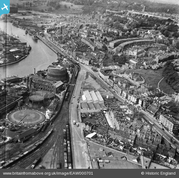
EAW000701 ENGLAND (1946). Anchor Road and the Cathedral Garage looking towards Clifton Wood, Bristol, 1946
© Hawlfraint cyfranwyr OpenStreetMap a thrwyddedwyd gan yr OpenStreetMap Foundation. 2026. Trwyddedir y gartograffeg fel CC BY-SA.
Delweddau cyfagos (22)
EAW000701

EAW000704

EAW000702

EAW000705

EPW001269

EAW002261

EAW002260

EAW000699

EAW000698

EAW000700

EAW000703

EAW002258

EAW033321

EAW002048

EAW250863

EPW005447

EPW005449

EPW005450

EPW005451

EPW005452

EPW005448

EPW005441

Manylion
| Pennawd | [EAW000701] Anchor Road and the Cathedral Garage looking towards Clifton Wood, Bristol, 1946 |
| Cyfeirnod | EAW000701 |
| Dyddiad | 9-May-1946 |
| Dolen | |
| Enw lle | BRISTOL |
| Plwyf | |
| Ardal | |
| Gwlad | ENGLAND |
| Dwyreiniad / Gogleddiad | 357973, 172582 |
| Hydred / Lledred | -2.6048664828713, 51.45017223995 |
| Cyfeirnod Grid Cenedlaethol | ST580726 |
Pinnau

Sparky |
Tuesday 26th of September 2017 12:24:26 PM | |
|
Sparky |
Friday 4th of August 2017 02:01:36 PM | |

clippedwings |
Thursday 19th of September 2013 02:46:12 PM | |

MB |
Tuesday 17th of September 2013 11:29:36 PM | |
|
MB |
Tuesday 17th of September 2013 11:28:27 PM | |
|
MB |
Tuesday 17th of September 2013 11:27:49 PM | |
+There were certainly lots of them. Visiting Grandparents in 1944/45 we were shown round lots of bombed-out buildings, particularly the large number of churches that had been hit. The smell of charred timbers and the damp, musty smell of rubble is with me now. In the 1960's there were still plenty of bomb sites, many usefully serving as car parks, (mostly free), happy days! |
clippedwings |
Thursday 19th of September 2013 03:06:56 PM |
|
MB |
Tuesday 17th of September 2013 11:27:06 PM | |
|
MB |
Tuesday 17th of September 2013 11:26:25 PM | |
|
MB |
Tuesday 17th of September 2013 11:25:51 PM | |
|
MB |
Tuesday 17th of September 2013 11:25:02 PM | |
|
MB |
Tuesday 17th of September 2013 11:24:07 PM | |
|
MB |
Tuesday 17th of September 2013 11:23:02 PM | |
|
MB |
Tuesday 17th of September 2013 11:21:52 PM | |
|
MB |
Tuesday 17th of September 2013 11:20:51 PM | |
|
MB |
Tuesday 17th of September 2013 11:20:31 PM | |
|
MB |
Tuesday 17th of September 2013 11:20:07 PM | |
|
MB |
Tuesday 17th of September 2013 11:19:40 PM | |
|
MB |
Tuesday 17th of September 2013 11:18:54 PM | |
|
MB |
Tuesday 17th of September 2013 11:17:26 PM | |
|
MB |
Tuesday 17th of September 2013 11:16:45 PM | |
|
MB |
Tuesday 17th of September 2013 11:15:52 PM | |
|
MB |
Tuesday 17th of September 2013 11:15:14 PM | |
|
MB |
Tuesday 17th of September 2013 11:14:41 PM | |
|
MB |
Tuesday 17th of September 2013 11:13:43 PM |