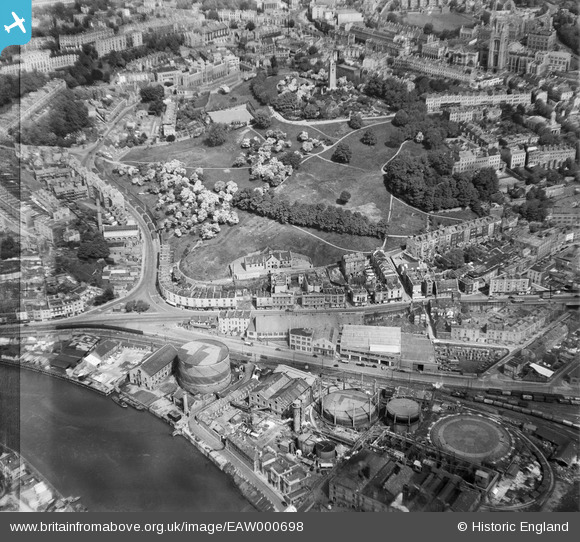
EAW000698 ENGLAND (1946). Brandon Hill, Bristol, 1946
    © Hawlfraint cyfranwyr OpenStreetMap a thrwyddedwyd gan yr OpenStreetMap Foundation. 2025. Trwyddedir y gartograffeg fel CC BY-SA.
  
Delweddau cyfagos (20)
Manylion
| Pennawd | [EAW000698] Brandon Hill, Bristol, 1946 | 
| Cyfeirnod | EAW000698 | 
| Dyddiad | 9-May-1946 | 
| Dolen | |
| Enw lle | BRISTOL | 
| Plwyf | |
| Ardal | |
| Gwlad | ENGLAND | 
| Dwyreiniad / Gogleddiad | 357959, 172666 | 
| Hydred / Lledred | -2.6050779481285, 51.450926535184 | 
| Cyfeirnod Grid Cenedlaethol | ST580727 | 
Pinnau
|  WW2 Camouflage Scheme Public Utility Gasworks |   Sparky | Tuesday 26th of September 2017 12:25:55 PM | 
|  WW2 Camouflage Scheme |   Sparky | Friday 4th of August 2017 01:59:48 PM | 
|  WW2 Camouflage Scheme |   Sparky | Friday 4th of August 2017 01:58:39 PM | 
|  Site of the 19th century (1855) St.Peter's Church until 1939 and which became occupied with a 1950s high-rise (8-storey) block of flats and maisonettes. This Clifton Wood church was closed in 1938 due to the decrease in religiosity in 1930s Bristol. | John Swain | Friday 12th of May 2017 09:26:38 AM | 
|  Cabot Tower (105 feet high), completed in 1897 to commemorate John Cabot's discovery of Newfoundland four centuries earlier. | John Swain | Friday 12th of May 2017 09:07:01 AM | 
|  An interesting conundrum is the row of pallets extending down the right-hand side of Jacob's Wells Road. Timber storage for the sawmills at Canon's Marsh or could they be building materials for the pre-fabricated, single-storey housing units constructed in post-war Bristol (Sea Mills)? | John Swain | Friday 12th of May 2017 09:05:10 AM | 
|  On an Edwardian large-scale map of the area, this building is shown as the Public Baths. | John Swain | Friday 12th of May 2017 08:50:41 AM | 
|  Bristol Grammar School | John Swain | Thursday 11th of May 2017 03:03:49 PM | 
|  Evidence of wartime bomb damage in the areas between St.George's Road and Anchor Road. | John Swain | Thursday 11th of May 2017 03:01:15 PM | 
|  College Street | John Swain | Thursday 11th of May 2017 02:57:47 PM | 
|  Great George Street | John Swain | Thursday 11th of May 2017 02:55:53 PM | 
|  Queen's Parade | John Swain | Thursday 11th of May 2017 02:54:20 PM | 
|  Wills Memorial Tower (1925) | John Swain | Thursday 11th of May 2017 02:52:56 PM | 
|  St. George's Church, built in the 1820s and now a concert venue. | John Swain | Thursday 11th of May 2017 02:42:58 PM | 
|  Queen Elizabeth's Hospital School | John Swain | Thursday 11th of May 2017 02:40:55 PM | 
|  Bowling Green | John Swain | Thursday 11th of May 2017 02:39:28 PM | 
|  Brandon Hill | John Swain | Thursday 11th of May 2017 02:34:31 PM | 
|  St.George's Primary School | John Swain | Thursday 11th of May 2017 02:33:49 PM | 
|  Bellevue Crescent | John Swain | Thursday 11th of May 2017 02:32:57 PM | 
|  Hotwell Road | John Swain | Thursday 11th of May 2017 02:31:52 PM | 
|  St.George's Road | John Swain | Thursday 11th of May 2017 02:31:13 PM | 
|  Jacob's Wells Road | John Swain | Thursday 11th of May 2017 02:30:04 PM | 
|  Gasworks Ferry | John Swain | Thursday 11th of May 2017 02:28:09 PM | 
|  Anchor Lane | John Swain | Thursday 11th of May 2017 02:26:42 PM | 
|  Canon's Marsh freight line opened in 1906 and linked to Ashton Gate via the Ashton Avenue Bridge to the west-south-west. | John Swain | Thursday 11th of May 2017 02:25:28 PM | 
|  Railway sidings at Canon's Marsh | John Swain | Thursday 11th of May 2017 02:17:09 PM | 
|  Floating Harbour | John Swain | Thursday 11th of May 2017 02:15:16 PM | 
|  Gas works at Canon's Marsh | John Swain | Thursday 11th of May 2017 02:13:30 PM | 
Cyfraniadau Grŵp
| An interesting view of the area to the west of the city centre, only twelve months after the conclusion of World War II in Europe. Looking almost due north from a position over the Floating Harbour, the photo is readily compared to the large-scale maps of the period. | John Swain | Thursday 11th of May 2017 03:12:26 PM | 
 
             
  ![[EAW000698] Brandon Hill, Bristol, 1946](http://britainfromabove.org.uk/sites/all/libraries/aerofilms-images/public/100x100/EAW/000/EAW000698.jpg) 
  
                                          ![[EAW000704] Brandon Hill and environs, Bristol, from the south-east, 1946](http://britainfromabove.org.uk/sites/all/libraries/aerofilms-images/public/100x100/EAW/000/EAW000704.jpg) 
 ![[EAW000702] Anchor Road and the Cathedral Garage looking towards Bellevue Crescent, 1946](http://britainfromabove.org.uk/sites/all/libraries/aerofilms-images/public/100x100/EAW/000/EAW000702.jpg) 
 ![[EAW002260] Brandon Hill, Canon's Marsh and the city, Bristol, 1946](http://britainfromabove.org.uk/sites/all/libraries/aerofilms-images/public/100x100/EAW/002/EAW002260.jpg) 
 ![[EAW000699] Brandon Hill, St George's Road and environs, Bristol, 1946](http://britainfromabove.org.uk/sites/all/libraries/aerofilms-images/public/100x100/EAW/000/EAW000699.jpg) 
 ![[EPW001269] Bristol Cathedral and Brandon Hill with the Cabot Tower, 1920](http://britainfromabove.org.uk/sites/all/libraries/aerofilms-images/public/100x100/EPW/001/EPW001269.jpg) 
 ![[EAW000703] The Cathedral Garage, Brandon Hill and environs, Bristol, 1946](http://britainfromabove.org.uk/sites/all/libraries/aerofilms-images/public/100x100/EAW/000/EAW000703.jpg) 
 ![[EAW002258] Brandon Hill, Canon's Marsh and the city, Bristol, 1946](http://britainfromabove.org.uk/sites/all/libraries/aerofilms-images/public/100x100/EAW/002/EAW002258.jpg) 
 ![[EAW000701] Anchor Road and the Cathedral Garage looking towards Clifton Wood, Bristol, 1946](http://britainfromabove.org.uk/sites/all/libraries/aerofilms-images/public/100x100/EAW/000/EAW000701.jpg) 
 ![[EAW000705] Canon's Marsh Gas Works, Brandon Hill and environs, Bristol, from the south-east, 1946](http://britainfromabove.org.uk/sites/all/libraries/aerofilms-images/public/100x100/EAW/000/EAW000705.jpg) 
 ![[EAW002261] Brandon Hill, Canon's Marsh and the city, Bristol, 1946](http://britainfromabove.org.uk/sites/all/libraries/aerofilms-images/public/100x100/EAW/002/EAW002261.jpg) 
 ![[EAW000700] Canon's Marsh Gas Works and environs, Bristol, 1946](http://britainfromabove.org.uk/sites/all/libraries/aerofilms-images/public/100x100/EAW/000/EAW000700.jpg) 
 ![[EPW005449] Fry's building on St George's Road, Bristol, 1921](http://britainfromabove.org.uk/sites/all/libraries/aerofilms-images/public/100x100/EPW/005/EPW005449.jpg) 
 ![[EPW005447] St George's Road and Brandon House, Bristol, 1921](http://britainfromabove.org.uk/sites/all/libraries/aerofilms-images/public/100x100/EPW/005/EPW005447.jpg) 
 ![[EPW005450] Fry's building on St George's Road, Bristol, 1921](http://britainfromabove.org.uk/sites/all/libraries/aerofilms-images/public/100x100/EPW/005/EPW005450.jpg) 
 ![[EPW005451] Fry's building on St George's Road, Bristol, 1921](http://britainfromabove.org.uk/sites/all/libraries/aerofilms-images/public/100x100/EPW/005/EPW005451.jpg) 
 ![[EPW005452] Fry's building on St George's Road, Bristol, 1921](http://britainfromabove.org.uk/sites/all/libraries/aerofilms-images/public/100x100/EPW/005/EPW005452.jpg) 
 ![[EPW005448] Fry's building on St George's Road, Bristol, 1921](http://britainfromabove.org.uk/sites/all/libraries/aerofilms-images/public/100x100/EPW/005/EPW005448.jpg) 
 ![[EAW033321] Brandon Hill and the city centre, Bristol, from the south, 1950](http://britainfromabove.org.uk/sites/all/libraries/aerofilms-images/public/100x100/EAW/033/EAW033321.jpg) 
 ![[EAW002048] Canon's Marsh, Bristol, 1946](http://britainfromabove.org.uk/sites/all/libraries/aerofilms-images/public/100x100/EAW/002/EAW002048.jpg)