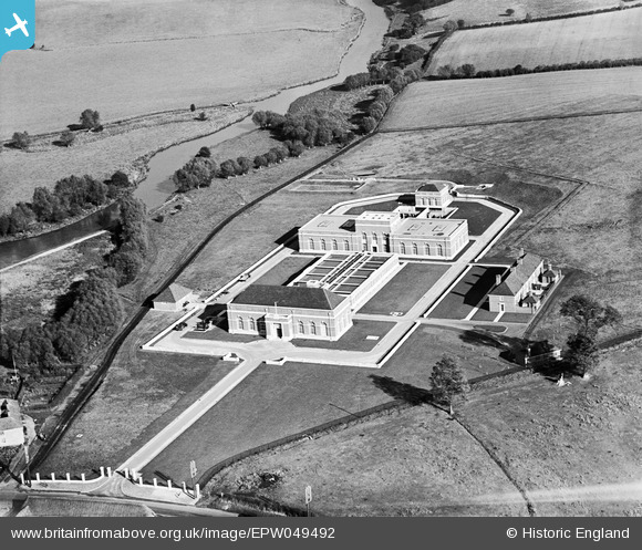
EPW049492 ENGLAND (1935). The Oxford Corporation Water Works, Swinford, 1935
© Copyright OpenStreetMap contributors and licensed by the OpenStreetMap Foundation. 2025. Cartography is licensed as CC BY-SA.
Nearby Images (7)
Details
| Title | [EPW049492] The Oxford Corporation Water Works, Swinford, 1935 |
| Reference | EPW049492 |
| Date | October-1935 |
| Link | |
| Place name | SWINFORD |
| Parish | CUMNOR |
| District | |
| Country | ENGLAND |
| Easting / Northing | 444583, 208537 |
| Longitude / Latitude | -1.3537745139698, 51.773275694854 |
| National Grid Reference | SP446085 |
Pins

Dylan Moore |
Tuesday 28th of May 2013 05:10:26 PM | |

Dylan Moore |
Friday 3rd of May 2013 02:18:27 PM | |
Hi Dylan, Thank you for identifying the location of this image. We'll update the catalogue and post the new record here in due course. Yours, Katy Britain from Above Cataloguing Team Leader |
Katy Whitaker |
Tuesday 2nd of July 2013 03:17:35 PM |


![[EPW049492] The Oxford Corporation Water Works, Swinford, 1935](http://britainfromabove.org.uk/sites/all/libraries/aerofilms-images/public/100x100/EPW/049/EPW049492.jpg)
![[EPW049496] The Oxford Corporation Water Works, Swinford, 1935](http://britainfromabove.org.uk/sites/all/libraries/aerofilms-images/public/100x100/EPW/049/EPW049496.jpg)
![[EPW049495] The Oxford Corporation Water Works, Swinford, 1935](http://britainfromabove.org.uk/sites/all/libraries/aerofilms-images/public/100x100/EPW/049/EPW049495.jpg)
![[EPW049494] The Oxford Corporation Water Works, Swinford, 1935. This image was marked by Aerofilms Ltd for photo editing.](http://britainfromabove.org.uk/sites/all/libraries/aerofilms-images/public/100x100/EPW/049/EPW049494.jpg)
![[EPW049498] The Oxford Corporation Water Works, Swinford, 1935](http://britainfromabove.org.uk/sites/all/libraries/aerofilms-images/public/100x100/EPW/049/EPW049498.jpg)
![[EPW049497] The Oxford Corporation Water Works, Swinford, 1935](http://britainfromabove.org.uk/sites/all/libraries/aerofilms-images/public/100x100/EPW/049/EPW049497.jpg)
![[EPW049493] The Oxford Corporation Water Works, Swinford, 1935](http://britainfromabove.org.uk/sites/all/libraries/aerofilms-images/public/100x100/EPW/049/EPW049493.jpg)