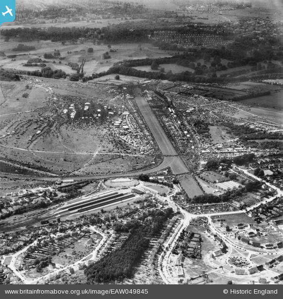
EAW049845 ENGLAND (1953). Epsom Downs, Derby Day, 1953
© Copyright OpenStreetMap contributors and licensed by the OpenStreetMap Foundation. 2026. Cartography is licensed as CC BY-SA.
Nearby Images (23)
Details
| Title | [EAW049845] Epsom Downs, Derby Day, 1953 |
| Reference | EAW049845 |
| Date | 6-June-1953 |
| Link | |
| Place name | EPSOM DOWNS |
| Parish | |
| District | |
| Country | ENGLAND |
| Easting / Northing | 522159, 158271 |
| Longitude / Latitude | -0.24716007416953, 51.309920253072 |
| National Grid Reference | TQ222583 |
Pins
Be the first to add a comment to this image!


![[EAW049845] Epsom Downs, Derby Day, 1953](http://britainfromabove.org.uk/sites/all/libraries/aerofilms-images/public/100x100/EAW/049/EAW049845.jpg)
![[EPW006441] Epsom Racecourse on Derby Day, Epsom Downs, 1921](http://britainfromabove.org.uk/sites/all/libraries/aerofilms-images/public/100x100/EPW/006/EPW006441.jpg)
![[EPW025140] Epsom Downs Race Course, Epsom Downs, from the south-west, 1928](http://britainfromabove.org.uk/sites/all/libraries/aerofilms-images/public/100x100/EPW/025/EPW025140.jpg)
![[EPW006400] Epsom Downs, Derby Day crowds at Epsom Racecourse, 1921. This image has been produced from a print.](http://britainfromabove.org.uk/sites/all/libraries/aerofilms-images/public/100x100/EPW/006/EPW006400.jpg)
![[EPW027459] Epsom Downs, Derby Day, 1929](http://britainfromabove.org.uk/sites/all/libraries/aerofilms-images/public/100x100/EPW/027/EPW027459.jpg)
![[EPW006382] Epsom Racecourse, Epsom Downs, from the east, 1921](http://britainfromabove.org.uk/sites/all/libraries/aerofilms-images/public/100x100/EPW/006/EPW006382.jpg)
![[EAW036447] Epsom Downs, the Epsom Derby underway, 1951. This image has been produced from a print.](http://britainfromabove.org.uk/sites/all/libraries/aerofilms-images/public/100x100/EAW/036/EAW036447.jpg)
![[EAW049846] Epsom Downs, Derby Day, 1953](http://britainfromabove.org.uk/sites/all/libraries/aerofilms-images/public/100x100/EAW/049/EAW049846.jpg)
![[EAW002166] Epsom Downs, The City and Surburban Race Meeting, 1946](http://britainfromabove.org.uk/sites/all/libraries/aerofilms-images/public/100x100/EAW/002/EAW002166.jpg)
![[EPW006364] Epsom Racecourse, Epsom Downs, from the north-east, 1921](http://britainfromabove.org.uk/sites/all/libraries/aerofilms-images/public/100x100/EPW/006/EPW006364.jpg)
![[EPW035517] Epsom Downs, The Straight and Tattenham Corner on Derby Day, 1931. This image has been produced from a damaged negative.](http://britainfromabove.org.uk/sites/all/libraries/aerofilms-images/public/100x100/EPW/035/EPW035517.jpg)
![[EPW006391] Epsom Downs, Derby Day at Epsom Racecourse, 1921. This image has been produced from a print.](http://britainfromabove.org.uk/sites/all/libraries/aerofilms-images/public/100x100/EPW/006/EPW006391.jpg)
![[EPW006384] Epsom Racecourse, Epsom Downs, from the east, 1921](http://britainfromabove.org.uk/sites/all/libraries/aerofilms-images/public/100x100/EPW/006/EPW006384.jpg)
![[EPW027461] Epsom Downs, Tattenham Corner on Derby Day, 1929](http://britainfromabove.org.uk/sites/all/libraries/aerofilms-images/public/100x100/EPW/027/EPW027461.jpg)
![[EAW017627] Fairground at Epsom Racecourse, Epsom Downs, 1948. This image has been produced from a print.](http://britainfromabove.org.uk/sites/all/libraries/aerofilms-images/public/100x100/EAW/017/EAW017627.jpg)
![[EPW007900] Epsom Racecourse, Epsom Downs, 1922](http://britainfromabove.org.uk/sites/all/libraries/aerofilms-images/public/100x100/EPW/007/EPW007900.jpg)
![[EAW002167] Epsom Downs, The City and Surburban Race Meeting, from the north, 1946](http://britainfromabove.org.uk/sites/all/libraries/aerofilms-images/public/100x100/EAW/002/EAW002167.jpg)
![[EPW025147] The Epsom Downs Race Course and Grand Stand, Epsom Downs, from the south-east, 1928](http://britainfromabove.org.uk/sites/all/libraries/aerofilms-images/public/100x100/EPW/025/EPW025147.jpg)
![[EAW000991] Epsom Downs, crowds at the Epsom Race Course Victory Derby, from the south, 1946. This image has been produced from a damaged negative.](http://britainfromabove.org.uk/sites/all/libraries/aerofilms-images/public/100x100/EAW/000/EAW000991.jpg)
![[EPW007653] The Home Straight at Epsom Racecourse, Epsom, from the east, 1922](http://britainfromabove.org.uk/sites/all/libraries/aerofilms-images/public/100x100/EPW/007/EPW007653.jpg)
![[EPW027457] Epsom Downs, Derby Day, 1929](http://britainfromabove.org.uk/sites/all/libraries/aerofilms-images/public/100x100/EPW/027/EPW027457.jpg)
![[EPW007656] Tattenham Corner, Epsom, 1922](http://britainfromabove.org.uk/sites/all/libraries/aerofilms-images/public/100x100/EPW/007/EPW007656.jpg)
![[EAW000997] Epsom Downs, crowds at the Epsom Race Course Victory Derby, from the south, 1946. This image has been produced from a damaged negative.](http://britainfromabove.org.uk/sites/all/libraries/aerofilms-images/public/100x100/EAW/000/EAW000997.jpg)