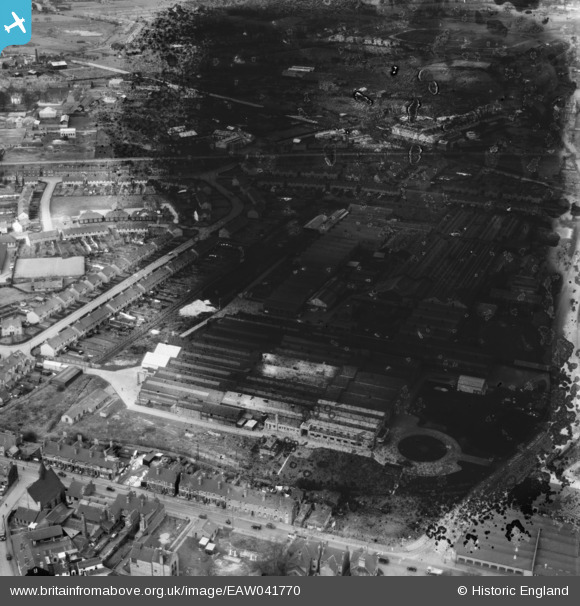
EAW041770 ENGLAND (1952). The John Harper and Co Ltd Albion Engineering Works, Willenhall, 1952. This image has been produced from a damaged negative.
© Copyright OpenStreetMap contributors and licensed by the OpenStreetMap Foundation. 2026. Cartography is licensed as CC BY-SA.
Nearby Images (19)
Details
| Title | [EAW041770] The John Harper and Co Ltd Albion Engineering Works, Willenhall, 1952. This image has been produced from a damaged negative. |
| Reference | EAW041770 |
| Date | 23-February-1952 |
| Link | |
| Place name | WILLENHALL |
| Parish | |
| District | |
| Country | ENGLAND |
| Easting / Northing | 397257, 298932 |
| Longitude / Latitude | -2.040492346229, 52.587828152448 |
| National Grid Reference | SO973989 |
Pins
Be the first to add a comment to this image!


![[EAW041770] The John Harper and Co Ltd Albion Engineering Works, Willenhall, 1952. This image has been produced from a damaged negative.](http://britainfromabove.org.uk/sites/all/libraries/aerofilms-images/public/100x100/EAW/041/EAW041770.jpg)
![[EAW041771] The John Harper and Co Ltd Albion Engineering Works, Willenhall, 1952. This image has been produced from a damaged negative.](http://britainfromabove.org.uk/sites/all/libraries/aerofilms-images/public/100x100/EAW/041/EAW041771.jpg)
![[EAW008389] John Harper and Co Ltd Albion Works on Clarkes Lane, Willenhall, 1947](http://britainfromabove.org.uk/sites/all/libraries/aerofilms-images/public/100x100/EAW/008/EAW008389.jpg)
![[EAW041775] The John Harper and Co Ltd Albion Engineering Works, Willenhall, 1952. This image has been produced from a damaged negative.](http://britainfromabove.org.uk/sites/all/libraries/aerofilms-images/public/100x100/EAW/041/EAW041775.jpg)
![[EAW041778] The John Harper and Co Ltd Albion Engineering Works, Willenhall, 1952. This image has been produced from a damaged negative.](http://britainfromabove.org.uk/sites/all/libraries/aerofilms-images/public/100x100/EAW/041/EAW041778.jpg)
![[EAW041777] The John Harper and Co Ltd Albion Engineering Works, Willenhall, 1952. This image has been produced from a damaged negative.](http://britainfromabove.org.uk/sites/all/libraries/aerofilms-images/public/100x100/EAW/041/EAW041777.jpg)
![[EPW061255] The Albion Machinery Works and the town, Willenhall, 1939](http://britainfromabove.org.uk/sites/all/libraries/aerofilms-images/public/100x100/EPW/061/EPW061255.jpg)
![[EAW008383] John Harper and Co Ltd Albion Works on Clarkes Lane, Willenhall, 1947](http://britainfromabove.org.uk/sites/all/libraries/aerofilms-images/public/100x100/EAW/008/EAW008383.jpg)
![[EAW008384] John Harper and Co Ltd Albion Works on Clarkes Lane, Willenhall, 1947](http://britainfromabove.org.uk/sites/all/libraries/aerofilms-images/public/100x100/EAW/008/EAW008384.jpg)
![[EAW008387] John Harper and Co Ltd Albion Works on Clarkes Lane, Willenhall, 1947](http://britainfromabove.org.uk/sites/all/libraries/aerofilms-images/public/100x100/EAW/008/EAW008387.jpg)
![[EAW008386] John Harper and Co Ltd Albion Works on Clarkes Lane, Willenhall, 1947](http://britainfromabove.org.uk/sites/all/libraries/aerofilms-images/public/100x100/EAW/008/EAW008386.jpg)
![[EAW008386A] John Harper and Co Ltd Albion Works on Clarkes Lane, Willenhall, 1947](http://britainfromabove.org.uk/sites/all/libraries/aerofilms-images/public/100x100/EAW/008/EAW008386A.jpg)
![[EAW041773] The John Harper and Co Ltd Albion Engineering Works, Willenhall, 1952. This image has been produced from a damaged negative.](http://britainfromabove.org.uk/sites/all/libraries/aerofilms-images/public/100x100/EAW/041/EAW041773.jpg)
![[EAW008390] John Harper and Co Ltd Albion Works on Clarkes Lane, Willenhall, 1947](http://britainfromabove.org.uk/sites/all/libraries/aerofilms-images/public/100x100/EAW/008/EAW008390.jpg)
![[EAW041779] The John Harper and Co Ltd Albion Engineering Works, Willenhall, from the south-west, 1952. This image was marked by Aerofilms Ltd for photo editing.](http://britainfromabove.org.uk/sites/all/libraries/aerofilms-images/public/100x100/EAW/041/EAW041779.jpg)
![[EAW008385] John Harper and Co Ltd Albion Works on Clarkes Lane, Willenhall, 1947](http://britainfromabove.org.uk/sites/all/libraries/aerofilms-images/public/100x100/EAW/008/EAW008385.jpg)
![[EAW008388] John Harper and Co Ltd Albion Works on Clarkes Lane, Willenhall, 1947](http://britainfromabove.org.uk/sites/all/libraries/aerofilms-images/public/100x100/EAW/008/EAW008388.jpg)
![[EAW041774] The John Harper and Co Ltd Albion Engineering Works, Willenhall, 1952. This image has been produced from a damaged negative.](http://britainfromabove.org.uk/sites/all/libraries/aerofilms-images/public/100x100/EAW/041/EAW041774.jpg)
![[EAW008382] John Harper and Co Ltd Albion Works on Albion Street, Willenhall, 1947. This image was marked by Aerofilms Ltd for photo editing.](http://britainfromabove.org.uk/sites/all/libraries/aerofilms-images/public/100x100/EAW/008/EAW008382.jpg)