
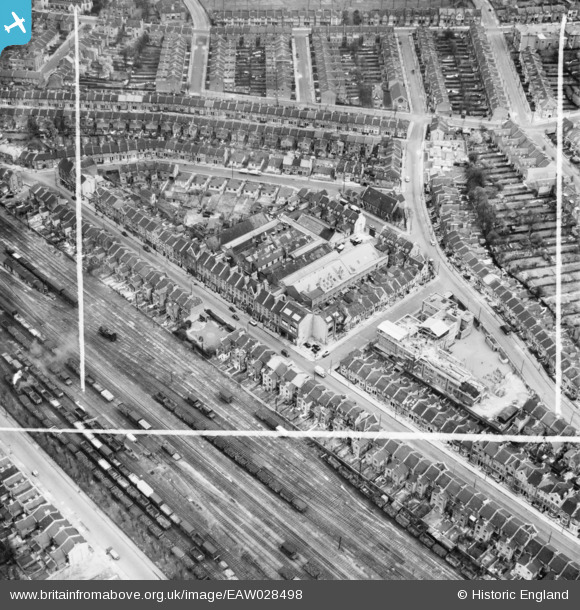
EAW028498 ENGLAND (1950). H.W. Nevill Ltd Bakery on Milkwood Road and environs, Herne Hill, 1950. This image was marked by Aerofilms Ltd for photo editing.
© Copyright OpenStreetMap contributors and licensed by the OpenStreetMap Foundation. 2026. Cartography is licensed as CC BY-SA.
Nearby Images (9)
EAW028498

EAW028496

EAW028491

EAW028492

EAW028493

EAW028495

EAW028497

EAW028490

EAW028494

Details
| Title | [EAW028498] H.W. Nevill Ltd Bakery on Milkwood Road and environs, Herne Hill, 1950. This image was marked by Aerofilms Ltd for photo editing. |
| Reference | EAW028498 |
| Date | 5-April-1950 |
| Link | |
| Place name | HERNE HILL |
| Parish | |
| District | |
| Country | ENGLAND |
| Easting / Northing | 531999, 175224 |
| Longitude / Latitude | -0.099745178177517, 51.460091930276 |
| National Grid Reference | TQ320752 |
Pins

Ron@88 |
Thursday 5th of January 2017 11:11:51 AM | |
|
Ron@88 |
Thursday 5th of January 2017 11:09:47 AM | |
|
Ron@88 |
Thursday 5th of January 2017 11:08:03 AM | |
|
Ron@88 |
Thursday 5th of January 2017 11:06:18 AM | |
|
Ron@88 |
Thursday 5th of January 2017 11:04:45 AM | |
|
Ron@88 |
Thursday 5th of January 2017 10:59:56 AM | |
|
Ron@88 |
Thursday 5th of January 2017 10:57:52 AM | |
|
Ron@88 |
Thursday 5th of January 2017 10:55:48 AM | |
|
brianbeckett |
Wednesday 17th of September 2014 07:24:58 PM | |
|
brianbeckett |
Wednesday 17th of September 2014 07:24:13 PM | |
|
brianbeckett |
Wednesday 17th of September 2014 07:23:55 PM | |
Should be MILKWOOD, Brian - small typo in your address. |
Ron@88 |
Thursday 5th of January 2017 11:16:00 AM |