
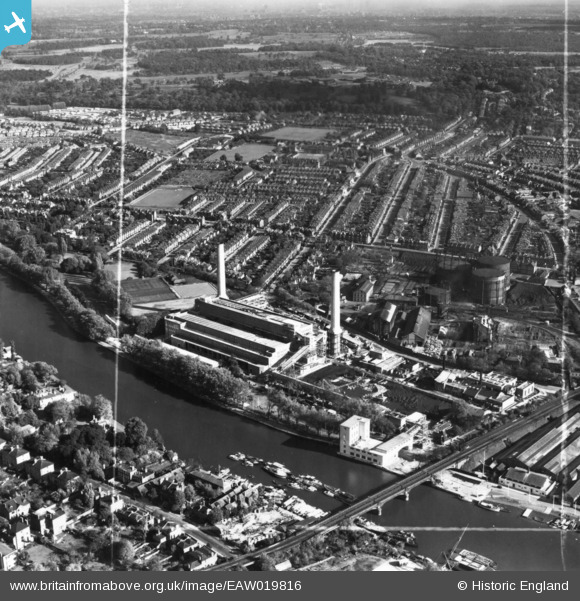
EAW019816 ENGLAND (1948). Kingston Power Station, Kingston Bridge and environs, Kingston Upon Thames, 1948. This image has been produced from a print marked by Aerofilms Ltd for photo editing.
© Copyright OpenStreetMap contributors and licensed by the OpenStreetMap Foundation. 2026. Cartography is licensed as CC BY-SA.
Nearby Images (9)
EAW019816

EAW019819

EAW019821

EAW019815

EAW019818

EAW019820

EAW019822

EAW019817

EPW053661

Details
| Title | [EAW019816] Kingston Power Station, Kingston Bridge and environs, Kingston Upon Thames, 1948. This image has been produced from a print marked by Aerofilms Ltd for photo editing. |
| Reference | EAW019816 |
| Date | 18-October-1948 |
| Link | |
| Place name | KINGSTON UPON THAMES |
| Parish | |
| District | |
| Country | ENGLAND |
| Easting / Northing | 518018, 169937 |
| Longitude / Latitude | -0.30267744273266, 51.415657361845 |
| National Grid Reference | TQ180699 |
Pins

UPONTHAMES |
Tuesday 24th of May 2022 10:01:08 PM | |
|
UPONTHAMES |
Tuesday 24th of May 2022 09:51:30 PM | |
|
UPONTHAMES |
Tuesday 24th of May 2022 09:25:41 PM | |
|
Simon |
Monday 30th of August 2021 05:10:34 PM | |
|
Simon |
Monday 30th of August 2021 05:08:35 PM |