
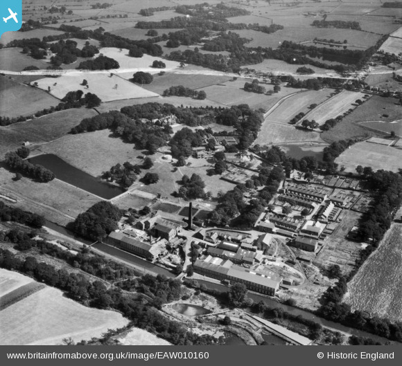
EAW010160 ENGLAND (1947). The Wiggins Teape and Co Withnell Fold Paper Mills and environs, Withnell Fold, 1947. This image was marked by Aerofilms Ltd for photo editing.
© Copyright OpenStreetMap contributors and licensed by the OpenStreetMap Foundation. 2026. Cartography is licensed as CC BY-SA.
Nearby Images (16)
EAW010160

EAW010389

EAW012424

EAW010159

EAW012422

EAW010161

EAW010390

EAW010388

EAW012423

EAW012427

EAW012428

EAW012421

EAW012429

EAW010163

EAW012425

EAW010162

Details
| Title | [EAW010160] The Wiggins Teape and Co Withnell Fold Paper Mills and environs, Withnell Fold, 1947. This image was marked by Aerofilms Ltd for photo editing. |
| Reference | EAW010160 |
| Date | 29-August-1947 |
| Link | |
| Place name | WITHNELL FOLD |
| Parish | WITHNELL |
| District | |
| Country | ENGLAND |
| Easting / Northing | 361320, 423159 |
| Longitude / Latitude | -2.5859876981132, 53.703202355474 |
| National Grid Reference | SD613232 |
Pins

DAVEASP1 |
Tuesday 7th of January 2014 03:28:46 PM | |
|
DAVEASP1 |
Tuesday 7th of January 2014 03:26:43 PM | |
|
TomRobin |
Wednesday 20th of November 2013 12:08:00 AM | |
|
TomRobin |
Wednesday 20th of November 2013 12:07:32 AM | |
|
TomRobin |
Tuesday 19th of November 2013 11:55:43 PM | |
|
TomRobin |
Tuesday 19th of November 2013 11:51:50 PM |

