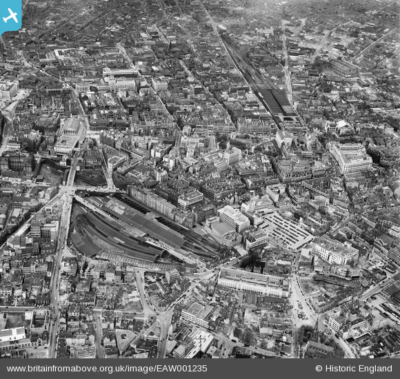
EAW001235 ENGLAND (1946). New Street and Snow Hill Railway Stations and the city centre, Birmingham, 1946

© Copyright OpenStreetMap contributors and licensed by the OpenStreetMap Foundation. 2024. Cartography is licensed as CC BY-SA.

Nearby Images (36)

EAW001235
  0° 0m
EAW015327
  332° 23m
EAW035107
  11° 33m
EAW001237
  177° 80m
EAW035108
  198° 81m
EAW001238
  74° 84m
EPW057481
  104° 86m
EPW048093
  65° 95m
EAW001239
  345° 124m
EPW057480
  321° 140m
EPW038601
  189° 141m
EPW053091
  357° 145m
EPW005840
  193° 154m
EAW001236
  330° 160m
EPW058129
  183° 171m
EAW013568
  79° 173m
EAW001234
  282° 175m
EPW022586
  200° 181m
EAW029414
  0° 208m
EAW029415
  355° 211m
EPW005835
  290° 213m
EAW013567
  58° 220m
EPW005849
  335° 220m
EPW005843
  313° 224m
EPW041475
  206° 232m
EAW013572
  45° 239m
EAW026255
  44° 239m
EPW001136
  229° 242m
EAW026252
  197° 244m
EPW005853
  305° 248m
EPW037053
  275° 248m
EAW026254
  134° 259m
EAW013573
  60° 265m
EAW026253
  232° 266m
EPW057482
  222° 274m
EAW013571
  46° 305m

Details

Title [EAW001235] New Street and Snow Hill Railway Stations and the city centre, Birmingham, 1946
Reference EAW001235
Date 24-June-1946
Link
Place name BIRMINGHAM
Parish
District
Country ENGLAND
Easting / Northing 406978, 286832
Longitude / Latitude -1.8972446399672, 52.479000245845
National Grid Reference SP070868

Pins

LOCATION OF 'THE NATWEST TOWER'..CORNER OF COLMORE ROW AND NEWHALL STREET.......CURRENTLY BEING DEMOLISHED AFTER BEING EMPTY FOR SEVERAL YEARS.

Griffin
Tuesday 24th of November 2015 10:24:58 PM

Griffin
Tuesday 24th of November 2015 10:20:57 PM
LOCATION OF 'WILLIAM POWELL & SON (GUNMAKERS) LTD' EST.1802. THEY WERE THE OLDEST FAMILY OWNED GUN MAKERS IN THE UK. MOVED TO THIS SITE AND ERECTED THIS FIVE STOREY BUILDING IN CARRS LANE IN 1860. BUILDING STILL STANDS, THE LAST REMAINING VICTORIAN BUILDING IN CARRS LANE, BUT THE COMPANY WAS SOLD TO J.M. OSBORNE & Co IN 2008, WHO MOVED THE COMPANY TO LARGER PREMISES IN BANBURY. AFTER MANY GENERATION THERE ARE NO POWELL FAMILY MEMBERS INVOLVED WITH THE FIRM BUT THE NAME SOLDIERS ON.

Griffin
Tuesday 24th of November 2015 09:30:40 PM
'MARTINEAU STREET'....SHORTENED WHEN THE SITE WAS REDEVELOPED AND 'MARTINEAU SQUARE' CREATED. HAS NOW DISAPPEARED COMPLETELY AFTER BECOMING SHORTER AND SHORTER AS PHASE AFTER PHASE OF CONSTRUCTION AND REDEVELOPMENT OCCURRED.

Griffin
Tuesday 24th of November 2015 09:27:12 PM
THIS WOULD HAVE BEEN THE 'WOOLWORTHS' STORE, SPICEAL STREET. REPLACED WITH A NEW BUILDING HOUSING THE STORE WHEN THE BULL RING WAS CONSTRUCTED IN THE 1960'S.

Griffin
Tuesday 24th of November 2015 08:19:05 PM
No 12 BENNETTS HILL...BLUE PLAQUE SHOWING WHERE 'EDWARD BURNE-JONES' USED TO LIVE. HE ATTENDED 'KING EDWARD VI SCHOOL, NEW STREET, DESIGNED THE WINDOWS IN THE APSE OF ST PHILIP'S CATHEDRAL AND HIS WORKS ARE ON DISPLAY IN THE BIRMINGAM MUSEUM AND ART GALLERY.

Griffin
Tuesday 24th of November 2015 08:17:18 PM
Great Western line stations to Birkenhead.

Triggy
Tuesday 24th of November 2015 08:14:33 PM
LOCATION OF WHERE A BRANCH OF 'THE NATIONAL PROVINCIAL BANK' USED TO BE. THIS MERGED WITH THE 'WESTMINSTER BANK', ALONG WITH 'THE DISTRICT BANK' IN THE LATE 1960'S TO FORM 'THE NATIONAL WESTMINSTER BANK'....THIS WAS EVENTUALLY TAKEN OVER BY 'RBS' (THE ROYAL BANK OF SCOTLAND). THE MAIN ENTRANCE WAS AT THE CORNER OF BENNETTS HILL AND WATERLOO ST, WITH AN INTERNAL DOMED PORCH, COVERED IN MOSAIC, CERAMICS AND WITH GLAZED WALL PANELS. ON THE TOP PARAPETS THE INSCRIPTION READS **NATIONAL PROVINCIAL BANK OF ENGLAND ESTAB: MDCCCXXXIII**....(1833)....NOW A WINE BAR.

Griffin
Tuesday 24th of November 2015 08:14:06 PM
Birmingham Snow Hill Station.

Triggy
Tuesday 24th of November 2015 08:12:59 PM
LOCATION OF THE 'BIRMINGHAM BANKING COMPANY' PREMISES...CORNER OF WATERLOO ST AND BENNETT'S HILL.

Griffin
Tuesday 24th of November 2015 07:50:36 PM
LOCATION OF 'THE TROCADERO'...GRADE II LISTED PUB ON THE SITE OF A GIN PALACE..TEMPLE STREET.... BEFORE 1912 IT WAS THE 'BODEGA' WINE BAR.(ALTERED IN 1883)...AND ORIGINALLY A FIRE STATION..THE FIRE STATION HOUSE FOR THE NOWICH UNION INSURANCE COMPANY (1846). THE LOCATION OF WHERE THE FIREMAN'S POLE USED TO BE CAN STILL BE SEEN. IT IS REPUTED TO BE HAUNTED BY 'HENRY SKINNER' A PREVIOUS LANDLORD, MURDERED THERE IN 1896.

Griffin
Tuesday 24th of November 2015 07:46:25 PM
ROW OF BARROWS ALONG 'SPICEAL STREET' SELLING FRUIT & VEG. THE SELLERS WERE TRANSFERRED TO THE FIXED STALLS IN THE OUTDOOR MARKET AREAS WHEN THE RING ROAD WAS BUILT.

Griffin
Tuesday 24th of November 2015 07:01:13 PM
OLD MAP SHOWS THIS AS 'LEASE LANE'....NO LONGER EXISTS.

Griffin
Tuesday 24th of November 2015 06:50:21 PM
DUDLEY STREET.

Griffin
Tuesday 24th of November 2015 06:43:32 PM
EDGBASTON STREET......NOW PEDESTRIANISED.

Griffin
Tuesday 24th of November 2015 06:40:18 PM
'BATH PASSAGE'...ALSO LEADING TO 'LADYWELL WALK'.....STILL EXISTS AS A PASSAGE ALTHOUGH IT IS COVERED BY OFFICES WHERE IT MEETS 'DUDLEY ST'.

Griffin
Tuesday 24th of November 2015 06:35:31 PM
'LADYWELL PASSAGE'.....LEADING TO 'LADYWELL WALK'...NOW NO LONGER EXISTS.

Griffin
Tuesday 24th of November 2015 06:19:54 PM
THIS IS 'WROTTERSLEY STREET'...USED TO JOIN 'SMALLBROOK ST' AS SHOWN... NOW TRUNCATED TO ABOUT WHERE PIN SHOWS....THE NEW ROAD 'SMALLBROOK QUEENSWAY' WAS CONSTRUCTED AT A HIGHER LEVEL.

Griffin
Tuesday 24th of November 2015 06:03:12 PM
OLD MAP SHOWS THIS AS 'THE DRILL HALL'...THORP ST.

Griffin
Tuesday 24th of November 2015 05:51:42 PM
REMANTS OF 'THE BIRMINGHAM EMPIRE THEATRE' SHOWING THE RESULT OF BOMBING IN 1941....THIS WAS DEMOLISHED COMPLETELY IN 1951.

Griffin
Tuesday 24th of November 2015 05:46:29 PM
WORCESTER ST END OF 'QUEENS DRIVE'.....THIS PORTION WAS TO BECOME THE ENTRANCE OF THE 'NEW, REDEVELOPED'(sic) STATION WITH THE 'PALLASADES' ABOVE THE TICKETING HALL.

Griffin
Tuesday 24th of November 2015 05:42:27 PM
THE 'OLD REP' THEATRE, STATION STREET.

Griffin
Tuesday 24th of November 2015 05:37:33 PM
'QUEENS DRIVE'....SEPARATING THE PARTS OF NEW STREET STATION SERVED BY DIFFERENT RAILWAY COMPANIES. (THE 'MIDLAND RAILWAY' AND THE 'LONDON & NORTH WESTERN RAILWAY'.....WHICH MERGED TO BECOME THE 'LONDON MIDLAND & SCOTTISH' RAILWAY IN LATER YEARS.

Griffin
Tuesday 24th of November 2015 05:34:55 PM
LOCATION OF 'MARSHALL & SNELGROVE' DEPARTMENT STORE, NEW ST...(LOOKS LIKE THE NEW BUILDING BEING CONSTRUCTED)...NOW OCCUPIED BY THE 'BRITANNIA HOTEL'...STORE LAYOUT WAS VERY SIMILAR TO THAT OF THE TELEVISION COMEDY PROGRAMME 'ARE YOU BEING SERVED',ESPECIALLY THE LIFTS, THE FEW STEPS IN FRONT OF THEM TO DESCEND ONTO THE SALES FLOOR, THE LADY ASSISTANTS IN SLIM BLACK DRESSES ETC.

Griffin
Tuesday 24th of November 2015 05:14:51 PM
The Bull Ring - market trading in the area dates back to an 1154 Royal Charter of Market Rights to Peter de Bermingham from King Henry 11. The general area was known as Corn Cheaping and the name Bull Ring referred to a green within it used for bullbaiting. The "ring" was an iron hoop to which the bulls were tethered during baiting and then slaughter. The first major demolition and redevelopment of the area took place in the early 1960's with the moving of the market and the construction of the Bull Ring Shopping Centre. A second redevelopment, starting in 2000, saw the demolition of the 1960's shopping centre and the construction of a new indoor shopping centre which opened in 2003. This has been has been given the corrupted name "Bullring" which is a point of local controversy.

Glassman
Monday 14th of October 2013 08:32:18 AM
Market Hall. Opened in 1835 but badly bomb damaged in WW2. It returned to post war use with walls repaired but without a roof. A locally remembered feature was a sea mine, painted red, placed at the back entrance steps. The building was demolished circa 1959 - 60 for the major Bullring redevelopment.

Glassman
Sunday 13th of October 2013 08:49:04 AM
MOST OF THE WALLS LASTED UNTIL 1963/4....THE PORTICOS AND STEPS HAVING BEEN DEMOLISHED....AND THE AREA BECAME AN OPEN, LANDSCAPED, LEISURE SPACE CALLED 'MANZONI GARDENS', ACCESSED BY UNDERPASSES, AND SURROUNDED BY THE RING ROAD.

THE NEW BULLRING WEST MALL NOW OCCUPIES THIS AREA.

Griffin
Tuesday 24th of November 2015 11:10:20 AM

Glassman
Saturday 12th of October 2013 09:42:37 AM
St Martins Church. Current building constructed in 1873 but this has been the site of a church back to 1290, and possibly earlier.

Glassman
Saturday 12th of October 2013 08:54:42 AM
A street performer, possibly an escapologist (chains/straight jacket etc),and audience.

Glassman
Saturday 12th of October 2013 08:41:05 AM
Statue of Horatio Nelson A bronze statue by Richard Westmacott installed 1809. In 1961, during the first Bullring redevelopment, it was relocated but in the later Bullring redevelopment (2000 - 2005) it was returned to near its original position overlooking St Martins church.

Glassman
Saturday 12th of October 2013 08:34:47 AM
Birmingham Moor Street station

Maurice
Saturday 12th of October 2013 07:35:28 AM
Bomb sites and damaged buildings

MB
Friday 11th of October 2013 10:07:45 PM
Bomb sites and damaged buildings

MB
Friday 11th of October 2013 10:06:57 PM
Steam locomotive in a siding

MB
Friday 11th of October 2013 10:06:06 PM

MB
Friday 11th of October 2013 10:05:38 PM
Twin tramway tracks with an additional loop line

MB
Friday 11th of October 2013 10:04:28 PM
Two trams passing

MB
Friday 11th of October 2013 10:03:01 PM
Tramway tracks

MB
Friday 11th of October 2013 10:02:26 PM
Bomb sites, in all probability

MB
Friday 11th of October 2013 10:01:26 PM
Scamell type mechanical horse - a three-wheeled tractor hauling a trailer with a large load

MB
Friday 11th of October 2013 10:00:17 PM
Signalbox sited at the end of a New Street station platform. Behind it a steam locomotive waits, steam rising from the safety valves

MB
Friday 11th of October 2013 09:58:37 PM
Another LMS 2-6-4T steam locomotive

MB
Friday 11th of October 2013 09:57:01 PM
Train entering New Street behind an LMS 2-6-4T

MB
Friday 11th of October 2013 09:56:14 PM