
Groups
Britain From Above book
About the group Your choices of the best images for a forthcoming book on the History of Aerofilms
Created 21 March 2013

James Crawford |
||
|
My copy arrived yesterday and it is a remarkable publication, so many congratulations to all concerned!
My only query at this early stage concerns the caption on page 146 relating to the 1940 US National Archives' shot of the Heinkel HE111 flying over central London. Strictly speaking, the bomber is taking a path in a north-north-westerly direction, immediately above the London Docks at Wapping and Shadwell, with the Surrey Commercial Docks on its starboard side and the West India/Millwall Docks further east, on the Isle of Dogs. The Royal Docks are about four miles to the east (right) of the camera position, no doubt being bombarded by similar aircraft during the Battle of Britain. September 7, 1940, marked the start of the London Blitz, which continued for six months and resulted in the deaths of more than 20,000 civilians. A brilliant photograph, to be sure, and well worth the inclusion in "Aerofilms: A History of Britain from Above". |

John Swain |
|
|
So much has changed on this photo - it's rather difficult to pick out landmarks that hevn't changed! St Peters Church is still there but the shipyards have all gone and the site now occupied by the National Glass Centre and Sunderland University. Much of the housing, especially around the church has also gone.
With the demise of shipbuilding in 1986 the river is now much quieter than even this photo. A complete change in the urban landscape over two generations! |
Chells809 |
|
|
An estate of pre-fabs under construction showing how the country tackled a post war housing shortage
|
Martin |
|
|
I think this would be a great candidate for the book - so much has changed, including the new British Library and the completely remodelled terminus at Kings Cross.
|
Chells809 |
|
Oliver Brookes |
||
|
All part of the export drive. Latvia and Finland bought the type, both countries used the swastika as their national emblem. The Bulldog was a successful between the wars fighter, made famous by being the type crashed by Douglas Bader which resulted in his loosing both legs. His subsequent career, particularly his part in the Battle of Britain is well documented.
|
clippedwings |
|
|
No book of Aerofilms images would be complete without an example of the work of I.K.Brunel.
|
clippedwings |
|
|
This photo shows the aftermath of the Bath Blitz of 25/26 April 1942 on Bath with a number of bomb sites in view. We also see the Bath Midland railway station which is a favourite with railway enthusiasts. We can see how the railway was still important for freight traffic at that time. We can see the Bath gas works and we can see the smoke and steam being given off. Personally seeing the photo I can recall the taste of the fumes which pervaded the air in the vicinity. The smells have gone but some of the gas holders remain today. There are also examples of Georgian architecture to be seen. The area has changed considerably today.
|

Class31 |
|
|
My mother grew up in Bath and talks of the windows being blown out in the Blitz and having to get water from the local 'pit'. The water was then 'supposed' to be boiled before use. (pit = park - not sure of it's name)
|
Alison Cutforth |
|
|
There was a play area near Monksdale Road, Bath which was known as the pit. It has a stream running through it and is still there today. I have seen it named Moorfields Play Area and also Sand Pits Play Area.
|
Class31 |
|
|
clippedwings |
|
|
Katy Whitaker |
||
|
James Crawford |
||
|
James - some very beautiful and artistic pics of the bridge and the Firth of Forth, I agree, but I'd say that my suggested pic posted on 9 June shows the first two generations of river crossing hard at work - the vehicle ferry and the rail bridge. It's hard to imagine 50 years on, how much the economic prosperity and 'connectivity' of many places in the country was regulated by estuary ferries like this, notably the River Severn.
|
Chells809 |
|
|
The good folk of Hartlepool at leisure on a typically chilly day in March 1924. Even as early as the 1790s, Quakers from Darlington and Sunderland, many of them well-heeled bankers, made Seaton Carew a popular place to come for a holiday. In later decades, gas lighting was introduced along the promenade and a new sea wall was constructed, followed by a new prom in 1905 and the swimming baths in 1914. A railway poster of the time proclaimed "Healthful Hartlepool: Natural Beauties Unsurpassed-extensive promenade, beautiful bay, splendid sands and magnificent expanse of sand..The most bracing sea air in the Kingdom-The Durham Health&Holiday Resort".
I'm pleased to report that a fine day in any season still attracts large numbers of day-trippers to Seaton Carew, including this correspondent!! |
John Swain |
|
|
This photo is of enormous interest. Bletchley Park played such a significant part in the history of our country during WWII. The photo was taken only a year before the commencement of hostilities. It just cries out to be included. Please.
|
Class31 |
|
|
EPW008947
An interesting picture in itself, but the more so if compare to modern developments. It is also interesting in the way the picture has been revisited at a number of periods by identifiers and information built up over time. Leicestershire's Granite intrusions are not that well known! |

Maurice |
|
|
I like the atmosphere of this photo where the image varies from clear in the foreground and far distance, the middle distance is wreathed in mist.
|
Class31 |
|
|
A good, clear image of two of the Royal Docks taken during a busy working day in 1934. Just over three decades later, these docks would be in decline and destined for closure in 1981, to be followed by extensive programmes of urban regeneration, which are still in progress at the present time.
|
John Swain |
|
|
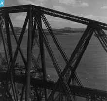
Some seriously low flying here - the iconic Forth Bridge from 1948
|
James Crawford |
|
|
Good thing that Aerofilms Ltd made a print - I saw the original negative when we were planning how to handle the nitrate film material that has undergone serious chemical change. It is just about possible to make out the ironwork, but the degredation was awful...
|
Katy Whitaker |
|
|
This image was taken less than four months before the start of World war II, during which the Surrey Commercial Docks and the surrounding area of Inner London suffered badly from German air attacks. The docks never recovered their former importance and finally closed in 1970, before undergoing extensive redevelopment since 1981.
|
John Swain |
|
|
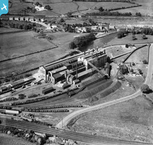
A great pic of the former iron and steel works at Consett, County Durham, which began in 1840 and lasted for another 140 years, until closure in 1980. The 650-acre site has now been cleared and reclaimed, so that hardly any vestige remains of one of Britain's major inland steelworks, which employed over 7,000 as late as 1970.
|
John Swain |
|
|
Not sure this is quite good enough, but the reflection of the cantilevers is almost perfect...
|
James Crawford |
|
|
James Crawford |
||
|
Unusual, atmospheric shot of Melrose Abbey from 1950 - taken in very low light...
|
James Crawford |
|
|
I'd like to suggest a photo of Oban for the book. I think it would be popular with many readers who will have been on holiday there in the past. There is also a shortage (so far) of Scottish pictures. Oban is special as a seaside resort, a passenger and cargo seaport and railway terminus. These old pics of Oban certainly show the greater influence that the railway had on seaside resorts - especially Oban and the huge area taken up by railway freight facilities. Oban also has some very impressive buildings so I think it should be considered.
|
Chells809 |
|
|
Great pic - we were just looking at this yesterday for the book. Very good chance it will feature
|
James Crawford |
|
|
Maurice |
|
|
Looks like the same plane with the camera at the same angle too.
|
Oliver Brookes |
|
|
James Crawford |
||
|
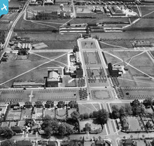
Great new image of the 1924-24 Empire Exhibition at Wembley - which was photographed on a monthly basis by Aerofilms to document changes to the site during construction.
|
James Crawford |
|
|
The idea of capturing a moment in time is wonderfully emphasised here with players caught in their play. A game that will be recorded and written about but where very few of the people there will still be alive. There is a tiny touching counterpoint to the big match with a girl on her swing alone in her garden. The image has an engaging abstract simplicity with the stand, the crowd and the gardens making simple clean shapes in strong light. It is successful on many levels and is visually engaging in its detail and in its grand scale.
|
Oliver Brookes |
|
|
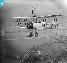
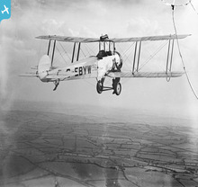
As air-to-air photos go, this is an excellent example. The Tiger Moth, one of De Havillands most successful aircraft was the training mount for thousands of service and civilian pilots. It was quite demanding to fly, but great fun.
|
clippedwings |
|
|
A new garden city in the making. This shows the early days of Welwyn Garden City town centre; streets and gardens laid out and the first buildings going up. These included the first shopping blocks, police station and theatre. By the outbreak of the Second World War much of the open space shown would be built over.
|
Chells809 |
|
|
An important point that I should add is that this picture beautifully illustrates the way that garden city town planning 'zoned' a new settlement into different districts. So, on this picture we have the residential development at the foot of the pic; the commercial/retail zone of the town centre in the middle; and the industrial area (such as the Shredded Wheat factory)at the top of the pic. This principle of separating the residential area from the industrial zone was later taken up in the post-war planning of the new towns, for example Stevenage. For that reason - as well as for being an interesting pic(!) - I think it should be a candidate for consideration.
|
Chells809 |
|
|
I strongly support your comment about the zoning of development. The well thought out planning of such towns also provided a structure that placed the town centre next to the railway station, in the realisation that many people from Welwyn would still be commuting to London for work. This allowed the town centre and the station to be a combined focus for public transport, making for a more efficient network serving more people well.
|
Maurice |
|
|
The dangers of flying
|
54mge |
|
|
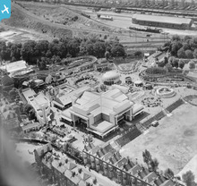
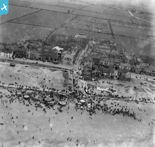
A great photo showing the old Butlin's amusement park in Littlehampton. It had opened the year before in 1932. The large roller coaster that can be seen in the top centre is long gone. The site has been redeveloped as Harbour Park, it is still an amusement park. There's a fine selection of cars in the photo as well as the odd charabanc, it must have been a warm summer's day
|
54mge |
|
|
A splendid photograph taken when both Hartlepools, Old and West, were famous for coal shipments and for producing a wide range of shipping. A decade before this picture was taken, the port installations attracted the attention of German gunners from ships in Hartlepool Bay and considerable damage was inflicted.
The scene is very different almost 90 years later, as most of the docks/shipyards have been closed or filled in, and the emphasis is now on leisure and tourism based around the Historic Quay/Marina. |
John Swain |
|
|
An image which reflects the industrial legacy of West Hartlepool and North East England, which lasted little more than a century, from modest beginnings in the 1860s, through mergers in late-Victorian times to create the South Durham Steel & Iron Company, to recession in the 1930s and a brief recovery in post-war Britain, before closure in 1977. This scene is very different at the present time!
|
John Swain |
|
|
I think that in principle we should be aiming for photos which reflect the age when they were taken. We should be aiming for human interest and vitality and not merely emulating existing albums of historic houses and beauty spots which can already be seen in albums such as "Britain from the Air" by Michael Swift and George Grant PRC Publishing 2000 ISBN 1 85648 561 7
We next to see such things as old farming practices, sttooks of corn, haystacks, horses in fields. Trams reflected the age. The charabancs and general traffic going to Derby Day has human interest. Old cars are of interest. The development of car parking is of interest as evidenced by the picture at Cheltenham Races. The planes themselves surely should be given a pivotal role together with any person whose likeness can actually be identified in a photo as a pilot or wing walker. I am fascinated by industrial archaeolgy and I think that we should include a selection of the best photos showing all sections of industry such as collieries, Mines, ironworks and steelworks, chemical works and factories. Housing is so important and again we should show closely packed victorian terraces together with the explosion of suburban housing with the onset of commuting. In short these pictures are unique and we should major on the uniqueness together with human interest. I would not want to see many photos in the book which are unchanged from what you can see today. |
Class31 |
|
|
Class 31, I very much agree with your comments on the general direction of such a work, especially in capturing the human and social atmosphere of the period and in so doing recording the degree of change.
This possibly raises an interesting question about whether such a publication should have any indication of the changes by the inclusion of modern images to emphasis the changing scene. General I feel that some of the various publications that seem to specialise in compare old pictures with new pictures taken from the same angle (one railway picture book series comes to mind) really don't do justice to the old as the new picture, often detracts from the interpretation of the 'now' of the past image. There are so many sources of modern aerial and terrestrial images, that it would seem unnecessary to waste space on providing such short cuts for the reader. However perhaps the text should provide some pointers as to where to find such images, at the risk of this becoming dated very quickly in the face of further technological changes. It might however be worth including some contemporary ground level shots that directly relate to the selected aerial images, but only if these add to the better understand of the aspect of human social or economic activity being developed in the picture caption. For example, one of my suggestions EPW039727 - Southampton Western Docks, might benefit from a view of the finished quay. |
Maurice |
|
|
I agree with your comments Class 31, especially the comments on industrial archaeology.
|
Chells809 |
|
|
Not only does this pic show one of the wonders of British engineering from an unusual angle (the rail bridge), it shows the ferry that used to connect both sides of the Firth of Forth until 1964 - well within living memory!
With the new road crossing of the River Forth now under construction this would be a great pic to show 'the way we used to live' and how what was once a great geographical and physical barrier (the River Forth) was conquered by the amazing achievements of two generations of the road bridge. |
Chells809 |
|
|
Dreamland in Margate - hopefully will be reconstructed soon. The iconic seaside destination for holiday makers years ago!
|
Martin |
|
|
I remember going there in 1969 on holiday - that and the old East Kent buses with their red and white livery and the fantastic fleetnames on the side.
|
Chells809 |
|
|
A clear image of the former market town of Stevenage in north Hertfordshire, looking north along the line of the old A1 (Great North Road), when the settlement consisted of fewer than 5,000 people. Just over twenty years later, in the immediate postwar period, Stevenage was designated as one of the original New Towns and it grew rapidly throughout the following decades to more than 85,000.
|
John Swain |
|
|
Good choice of pic, but this is the old town of Stevenage. Construction on Stevenage new town commenced in the late 1940s, at first some way away from the original older town located along the Great North Road which is pictured here. In time the new town pretty much joined up with the old town though the old town still has a very distinctive country market town atmosphere.
Any chance of a later pic of the new town under construction in the late 40s/early 50s? To illustrate changes in town planning in Britain this pic must be a candidate for the book, though it would be enhanced if a more recent pic could be added. |
Chells809 |
|
|
Even though I have no connection to the area this still has to be one of my favourite photos in the collection. Not only is it a great picture visually it has a story too being the site of the Match Girls Strike in 1888.
|
AJJ |
|
|
The partnership between the Quakers Francis May and William Bryant is not perhaps as socially concerned as some of the other great Quaker firms such as Clarks, Cadbury and Rowntree. They started with good intensions the company being founded with the specific aim of making only Safety Matches. Safety in that they did not contain white the phosphorus found in early matches that caused ‘phossy jaw’ (Symptoms of phossy jaw would begin suffering painful toothaches and swelling of the gums. Over time, the jawbone would begin to abscess. Affected bones would glow a greenish-white colour in the dark. It also caused serious brain damage. Surgical removal of the afflicted jawbones could save the patient; otherwise, death from organ failure would follow. The disease was extremely painful and disfiguring to the patient, with dying bone tissue rotting away accompanied by a foul-smelling discharge.)
The Bryant and May factory opened in 1861, on a dilapidated site in Bow which had once been used for the manufacture of candles, crinoline (a stiff fabric used in the then fashionable ladies skirts) and rope. This site was gradually expanded as a model factory. However, the public’s initial unwillingness to buy the more expensive safety matches (as much as three times the price of white phosphorous based matches) lead them to continue the manufacture of the traditional matches. While they showed concern about the safety of their product Bryant and May did not perhaps show the same concern about their employees. The company was targeted in the London match-girls strike of 1888, which won important improvements in working conditions and pay for the mostly female workforce, suggesting that a potentially voluntary improvement of conditions had to be force upon them. Members of the Fabian Society, including George Bernard Shaw and Sidney Webb, supported the striking match workers by contributing to the strike fund as well as spreading news of the strike. It was not until 1906 that the international Berne Convention and subsequent UK laws made in 1908 prohibited the use of white phosphorus, brought about the end of its industrial use. My wife Ann adds, “This is fascinating - and of more interest to me than most things as I can remember nursing men from the Bryant and May factory in Rachel Ward of the London Hospital during the late 50s and early 60s, but not with the gruesome symptoms outlined above!” |
Maurice |
|
|
Hi Maurice, really interesting to read your wife's comment - I'm interested in the way that Aerofilms images prompt connections between the "then" of the image, the "then" of our memories/experiences of the place, and the "now" of the place and what we are (currently) left with on the ground.
Katy |
Katy Whitaker |
|
|
Further to Class 31's objectives for a book, perhaps some thought needs to be given to the selection of subjects by Aerofilms. While some clearly have a commercial focus, sets of pictures being taken to order of new factories and so on, other seem to be rather more randomly selected, perhaps as nice shots on the way to contract work.
Such initial selection of these 'non-commercial' images would be influenced by the interests of the Aerofilms staff. We will then have the present selection suggested by Britain Form Above followers, again reflecting a range of interests.... In such a way the record of what was happening on the ground in the 1920s -30s is subject to both historic and modern bias by those making the selection of images. |
Maurice |
|
|
Wembley Stadium was built in 1922/23 as a multipurpose athletics and entertainment centre for the British Empire Exhibition of 1924/25, seen on the left-hand side (northern)of the photograph. Most of the exhibition buildings were designed by Sir John Simpson and Maxwell Ayrton and constructed in ferro-concrete, at a cost in excess of £10 million.
A rare image of one of the main venues for significant events of the "Roaring Twenties". Upwards of 25 million visitors attended the exhibition during the summer of 1924. |
John Swain |
|
|
John - Thanks for the comment on EPW005603 and the growth of London. The Wembley pictures, of which this is just one, attract me as my father worked on the site for the surveying firm Baker and Mallet before starting his career in the Southern and British Railways. I have made some annotations on other Wembley pictures relating to the Never Stop Railway which ran around the eastern and north sides of the site and which was of great fascination to my father.
As may be seen from many of my 'picture pins' it was railways that brought me to geography and geography that brought me to teaching in London and Devon. Like you, I am now retired. |
Maurice |
|
|
This symmetrical view of Exmouth is worthy of inclusion because of the synchronised symmetry of the houses bounded and seemingly restrained as they are by the metal girdle of the railway line. In addition even though the photo is taken at the height of the day there is hardly a pedestrian or car to be seen.
|
Allen T |
|
|
This photograph shows the industrial heart of the Black Country with the canal interchanging traffic with the railway. All now gone!
|
Martin |
|
|
Great light and a real sense of thriving industry and business
|
Oliver Brookes |
|
|
A well lit urban and industrial drama
|
Oliver Brookes |
|
|
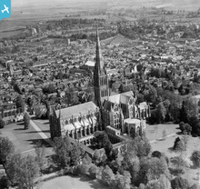
Salisbury Cathedral is a splendid example of pure Early English Gothic architecture and was built within a relatively short period of forty years (1220-1260). In this clear image taken exactly eighty years ago, on a fine spring morning, looking in a north-easterly direction, the various parts of the building lead the eye to the central point, the richly-adorned spire (1250), which is the loftiest in England (406 feet). The tallest church spire in the kingdom is surely worthy of inclusion.
|
John Swain |
|
|
It's slightly wonky but delightful nonetheless.
|
Katy Whitaker |
|
|
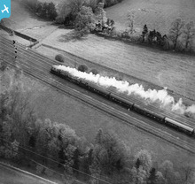
I suppose it's a toss-up between this picture of the LMS double-headed train heading towards Watford in 1931 and the slightly earlier one of the Johnson 3P class near Burton-upon-Trent. However, I shall show my southern (Watford/Hertfordshire) bias and plump for the former image for inclusion in next year's publication!
|
John Swain |
|
|
You're local like me John? I'd go for this one too!
Yours, Katy |
Katy Whitaker |
|
|
This picture suitably cropped at the railway lines to the right and just beyond the industrial estate is an iconic view of Wembley stadium and is of a high enough quality to be pulled up. Taken in 1924 it remains an atmospheric historical view.
|
Allen T |
|
|
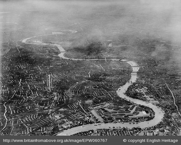
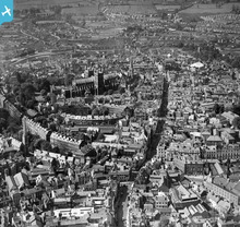
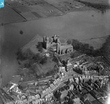
One of the most famous views in the North-East of England, with the dominant landmark of the Norman cathedral of Durham on the peninsula created by deeply incised meander bend of the River Wear. The building stands upon an outcrop of Durham Low Main Post Sandstone (Pennine Middle Coal Measures) and was built of stone from the same geological unit.
In this scene, the river is flowing in a northerly direction on the left of picture, away from the camera position. Most of the medieval city clustered to the north and east of the cathedral remains identifiable today. This image is an absolute must for the forthcoming publication! |
John Swain |
|
|
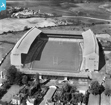
A splendid view of the old stadium, which became the HQ of the Rugby Football Union and home to the England team from 1910, when the accommodation for spectators was only 30,000 and there was limited parking for motor vehicles. Necessary expansion took place after the Great War, with the completion of the North Stand (at the far end of the ground) in 1925, followed by extensions to the East and West Stands, so that there was now (1932) provision for 23,000 seated spectators in the two double-decker stands. Just three months after this photograph was taken, an estimated crowd of more than 73,000 witnessed the first-ever English victory over the New Zealand All Blacks by 13 points to nil, in what became known as Prince Obolensky's Match. The ground remained relatively unchanged until the 1980s and the refurbished stadium (capacity 82,000), arguably the most famous in the world, is set to host the Rugby World Cup Final in the autumn of 2015. A far cry from Edwardian times, when Billy Williams (1860-1950)discovered the market garden near the River Thames and was able to persuade the RFU to buy the site of ten acres, for the princely sum of £5,572 12s 6d!!
|
John Swain |
|
|
Battersea was the most spectacular of the new generation of electricity power stations constructed during the 1930s and, at the time, Section A was the largest in Europe. The massive structure, with its great fluted chimneys, is industrial architecture at its best and has remained one of the best-known landmarks on the Thames for eighty years.
|
John Swain |
|
|
An excellent example of the 1930's suburban sprawl into the countryside as the Garden City movement campaigned for better housing and residents in overcrowded, insanitary properties moved into new council housing. This photo shows the first phase of Exeter's Burnthouse Lane Housing Estate built to accommodate the removal of occupiers of Exeter's oldest area, the West Quarter, where infant mortality and death rates were amongst the worst in the UK and up to three times higher than the rest of the city.
|
Allen T |
|
|
Allen T |
||
|
I would recommend this superb photo of Exeter for the book because it clearly and uniquely shows the centre of this medieval/Georgian and Victorian city just nine years before 70% of the buildings in the picture were destroyed in the May 1942 blitz. The reproductive quality of the photo is excellent and the detail in this pre-war snapshot in time is both invaluable and historically unique.
|
Allen T |
|
|
Another one of those iconic images from the Interwar Period and the latter stages of The Age of Steam, which surely deserves a place in the Aerofilms book.
|
John Swain |
|
|
An attractive composition of the 1912 Oxhey Golf Clubhouse, with a view of the 18th green on the course's original layout 1912-1936. This famous old course hosted tournaments throughout the interwar years, including the prestigious "News of the World" competitions.
The construction of the huge, postwar housing estate at South Oxhey, accommodating over 17,000 folk, in the 1940s resulted in the loss of more than 25% of the playing area at the east end and in the south-east corner of the links, and the club eventually closed in October 1946. A municipal course struggled on until March 1952, when it became the South Oxhey Playing Fields. The fine clubhouse has since been extended and is now "The Pavillion" restaurant, with a spacious car park on its northern side and a bowling green, with tennis courts, to the west. Since the demise of the golf course, the highly-prized facility of the playing fields has hosted several sports teams in over six decades and the varied topography has attracted regular visits from the Thames Valley Orienteering Club!! A fine example of the positive uses made of valuable Green Belt land, close to the northern boundary of Greater London. |
John Swain |
|
|
Indeed, Katy, but whatever has happened to the neo-Gothic church in the middle distance, where the nave appears to have been demolished, thus leaving the blackened Early English broach spire?
|
John Swain |
|
|
Re EPW036876 - I don't know the history of the church I'm afraid.
Yours, Katy |
Katy Whitaker |
|
|
An unusual view looking almost due north from Brookdene Avenue, Oxhey, towards the southern outskirts of the expanding market town of Watford (population 56,799 in 1931 census). It is now more than sixty years since I first became familiar with the area and I still visit some of the old haunts whenever I'm in South-west Herts, not least Watford Boys'GS, my alma mater from 1954-1961!
|
John Swain |
|
|
EPW005603 London County Council, County Hall
Much of the twentieth century growth of London occurred under and was facilitated by the London County Council. The LCC was created in 1889 to manage the largest urban area in the world, with its population of 6.48 million people (1900). To carry out its role of providing education (later under the Inner London Education Authority, ILEA), housing, transport and many other municipal undertakings it required a modern headquarters building. However modern in 1921 still included the provision of chimneys for the open fires in the many offices. It is interesting to note that some of the building materials are arriving by water. The LCC gave way to the Great London Council (GLC) in 1965, which took in a wider area including the outer suburbs as London Boroughs. By the 1980s, sitting on the south bank of the Thames diagonal opposite the Palace of Westminster, it had become symbolic of an alternative seat of power in London. With the disbanding of the GLC in 1986 the building ended it public function. The ILEA lasted a little longer until 1990, but eventually all services were to be run by the individual boroughs in both inner and outer London. The Mayor of London’s office is now bringing some of those functions, especially transport, back under central control, working from new offices near Tower Bridge. The focus of administration in the world largest capital city is worthy of inclusion. This could be linked to a group of pictures about the growth of London EPW031679, EPW035584, EPW017380, EPW007991 and EPW032791 |
Maurice |
|
|
An excellent point, well made, Maurice, with which I entirely agree. As a retired geographer with some interest in the capital, I also consult my Cassini Historical Map set on London, in addition to various editions of Bartholomew's Reference Atlas of Greater London. Let's hope that some, if not all, of these images are selected for inclusion in the forthcoming publication.
|
John Swain |
|
|
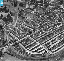
A classic shot of the large, sprawling council estate, with its characteristic geometric street patterns, on the eastern side of Sheffield, under construction for families rehoused from the inner city slums during the interwar period. At its peak in the 1930s, The Manor Estate contained a population of over 30,000, but many of these homes have since been demolished and the figure is now less than a third of that total.
|
John Swain |
|
|
A classic view of three of Tyneside's bridges looking north-east from the Gateshead side, from left to right in the photograph: High Level Bridge (1849), Swing Bridge (1876) and, the most famous, The Tyne Bridge (1928).
|
John Swain |
|
|
Built by London County Council between 1921 and 1934 on four square miles of flat land, near Dagenham, Barking and Ilford, this huge housing estate of 27,000 homes for 90,000 people was the largest of its kind in Europe between the wars, and so is worthy of inclusion.
|
John Swain |
|
|
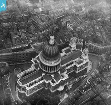
A different perspective on Wren's masterpiece (1675-1710), in the period before the reconstruction of the City of London in post-war years, when his enormous cathedral would be masked and dwarfed by the steel-and-concrete monsters of today!
|
John Swain |
|
|
A truly magnificent building viewed from the south-west before the Victorian clutter was cleared on its northern aspect. Surely one of the Capital's most iconic images and thus deserving of inclusion in a future Aerofilms book.
|
John Swain |
|
|
Show me an Aerofilms image without laundry in it and I'll give you a fiver...well, maybe not, but the point is this: a good drying day is a good flying day.
I love that lines of laundry here in Halifax run between the fronts of the houses across the streets. |
Katy Whitaker |
|
|
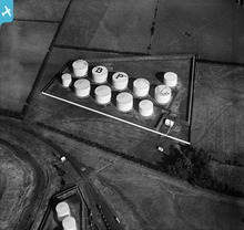
And BP were at it too!
|
Katy Whitaker |
|
|
So how many pilots did Pratts imagine would see this advertising as they made the final approach to Hedon aerodrome?!
|
Katy Whitaker |
|
|
Reminds me of hot, sunny days church-crawling...
|
Katy Whitaker |
|
|
The area's heyday and transition. Old industries have gone evidenced by the recently disused branch of the Ashton canal, not yet in decay. The Ferranti works now established was to make a huge contribution to the war effort. The rubber works, mills and Bower Colliery provided employment for thousands. The trams of Oldham and Manchester Corporations stand in their respective territories awaiting rush hour custom, by Oldham's Hollinwood tram depot (closed 1938).The recently opened Hollinwood Avenue (horizontally East to West) delineates the course of the present M60 Motorway, and other than the North to South railway line (Metrolink light rail since 2012), just about everything else in this view has either disappeared or fallen into the M60 chasm which now dominates. The local employment and extent of population having evaporated without trace.
|
keith |
|
|
WPW029701 Tenby
The Royal Victoria Pier for coastal steamers. Still in place on the 1966 map but gone by the 1968 map. Most of the UK coastal steamer services ended by the early 1960s if, indeed, they had returned after 1945. An idyllic piece of coastline. |
Maurice |
|
|
WPW041237 Newport Transporter Bridge
The high tidal range (fairly low tide in the picture) and the need not to obstruct river traffic made the transporter bridge a useful concept - a ferry out of the water. There were other transporter bridges in Middlesborough and Warrington. A novel way of over coming the ferry/bridge problem on busy waterways. |
Maurice |
|
|
SAW003588 Ben Nevis
What a magnificent picture. The more so as pictures like this can be hoped for but cannot be planned. |
Maurice |
|
|
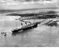
SPW040275 Queen Mary
After a decade in the making, a very fine looking vessel was produced, despite work being stopped during the depression, a government grant being provided to complete her. An iconic ship in an icon ship yard for an iconic service born out of an iconic depression! |
Maurice |
|
|
EPW039727 Southampton the Western Docks
The reclamation of the land behind the new Western Docks in Southampton was one of the largest non-rural reclamation schemes ever carried out in Britain. Unlike the reclamation of agricultural land from the sea in the Fens, the Somerset Level and around the Dee Estuary and Morecombe Bay in the north west of England, this land was intended for immediate industrial use. The ground level was made up with mud and silt dredged from the sea bed at various locations around Southampton Water and chalk brought by rail from a pit beside the main Southampton to London railway line at Micheldever, about 16 miles to the north. The new dock was built from the eastern end (the front of the picture). Here we see an early section with tugs and barges against the new wall, with the first of the transhipment sheds almost completed. In this middle section we see the progression of work towards a finished wall and dock surface. There is much construction equipment both on the new quay and in the water. On the final section (to the back of the picture) at the western end of the new dock there appears to be a cofferdam in place to allow the construction of the new wall on piles driven into the sea bed. Once the wall is completed and water tight the quay immediately behind can be consolidated and the area further back drained of the remaining water. The area at the top left of the picture has now been further developed as the Southampton Container Port from1970s onwards. This has taken the inland development of Southampton Docks as far as it can go. Future development will be on the opposite side of the river. Work on the site of the King George V Graving Dock (Dry Dock), which at 1,000ft long by 135ft wide and 45ft deep could take the largest ships afloat, although the 'Queen Mary' was going to be a tight squeeze. This dock replaced the float dry dock as seen in EPW032342. This was possibly one of the most significant railway company, non-railway developments, in the UK. Unlike later large transport projects (for example Heathrow Airport) Southampton Docks was the right project in the right place at the right time. This was not just for the benefit of the London and South Western Railway who made the initial purchase of the docks and later the Southern Railway under Sir Herbert Walker that developed the Western Docks. It remains a significant part of the British economy even today, as evidenced by the container ship, lorry and train traffic generated by the port. |
Maurice |
|
|
EPW027869 Partington Dock, Manchester Ship Canal
To discharge coal into ships the loaded Private Owner (PO) coal wagons, which had end doors, were pushed onto a lift/tipper. As the wagon was tipped the coal was shot into the ship. The wagon was then lifted to the upper level from were it rolled away empty to join the one before. Seen as the best way to do the job, such infrastructure was only very slowly replaced, even though the potential size and therefore the efficiency of railway wagons had increased. In this way such installations (often in private ownership), and their fossilised operating practices, retarded the growth of efficient mineral handling by the later nationalised railway. This only happen with the arrival of bottom discharge 'Merry-go-round' trains (1960s) where coal was dropped on the move from high capacity wagons as a complete train passed over the discharge point at slow speed. What the picture does not show are the many hours of breaking up and re-making trains as each wagon was dealt with separately.... hours of repetitive and unproductive work. It might be a Sunday when the picture was taken, as there are no signs of movement around any of the tips. It represents the inability to change and become more efficient that dogged much of British industry in the twentieth century and aided the decline of much of our economy. See also WPW016932 Newport Coal Dock |
Maurice |
|
|
EPW033556 Longford Castle
At one time, water meadows were an important technique in the management of floodplain farmland. A leat (small canal) was constructed to branch off from the main stream above the site, the flow of water being controlled by a sluice gate. The release of water into a system of distribution channels allowed irrigation when required. Excess water was drained off from the meadows by another separate set of channels, returning the water to the main stream below the site. Careful observation of the picture allows these two patterns to be seen. The feeder channels are larger and straight, while the slightly lower drains are more of herring bone pattern within the rectangles made by the former. This set of meadows is still visible on today satellite pictures, being just south east of Salisbury on the Avon. There is another set of meadows at Harnham in Salisbury that make an important element in the unchanging scene to the west of the Cathedral. Some have suggested that the decline of water meadows is an element, albeit a small one, in the causes of modern flooding. Their reintroduction would certainly help retard the flow of water down stream. The system would perhaps more importantly arrest the loss of topsoil carried down stream during flood episodes as the water meadows act as a filter trapping sediment and nutrients that improve the land. This is an excellent example of human activities using natural process to manage the landscape. An important and unfortunately much decline element of the English agricultural landscape, illustrated by this very will framed and defined picture. |
Maurice |
|
|
EPW033146 Lynmouth
Much of this area was damaged in the floods of 15-16th August 1952, when the side stream became a ranging torrent down the road. Today a wider channel has been engineered through Lynmouth to carry water to the sea. While sudden floods such as those in 1952 cause catastrophic changes in the landscape, many landforms are formed by attrition over much longer periods of time. For example the wave-cut platform (wave-cut bench), a marine erosion surface formed at the base of a cliff and gentle sloping towards the sea, that can be seen to the lower left of the picture. The tidal range controls both the horizontal and vertical extent of such features. This active erosion surface is strewn with boulders that have been eroded from the surface and become trapped in the depressions in the structure. The relatively flat area, with several trees, above the wave-cut platform suggests a 'relic feature' also cut by the sea but at the time of a relatively higher sea level. Such relative sea level change in this area might be account for by a small amount of isostatic uplift after the last ice age as the weight of the ice sheet that extended south to the Bristol Channel melted away. Behind the flat area is a relic sea cliff (covered in trees) that is now cut-off from the marine processes that formed it many thousand of years ago. There is a similar, but smaller, 'flat' on the western side of the mouth of the River Lyn to the right of the picture. There are other similar coastal flats along the north Somerset coast that suggest the process is repeated at other locations. Some are much larger as for example at Minehead. There is more to Lynmouth than the 1952 floods! |
Maurice |
|
|
EPW023620 Calstock
From the north (furthest end) of the viaduct the railway continues towards Callington having sharply turned 90 degrees to head eastwards and then turning180 degrees around the slope above the Tamar to appear on the north side of the road running east to west at the top of the picture. This line is still open as far as Gunnislake. The slopes above Calstock are, like much of the Tamar valley at this time, given over to production both flowers and vegetables. Many of these horticultural enterprises have now gone, some as the result of the loss of the ability to dispatch produce by rail from this area with poor road communications. There are railway sidings on the quay, 113 feet below the line on the viaduct. These were connected by the wagon lift, which was used to lower full wagons containing granite and other materials brought down from the Callington end of the branch to be carried on by water (sea). The lift was little used after 1912 and was dismantled in 1934. It was somewhat higher than similar hoists found in many two level urban goods depots for example at Spitalfields in east London. A good picture to show rural change. |
Maurice |
|
|
SPW019506 Wemyss Bay
This picture shows the delightfully clean lines of this piece of fairly complex architecture that could be many years younger than its actually age. It remains in this state today, although increased railway operating efficiency means the number of tracks and platforms used has been reduced. The symmetry of the pier has been broken by the addition of a roll-on roll-off ferry link-span on the southern (right-hand) side Delightful sharp picture of a lovely piece of architecture. |
Maurice |
|
|
EPW013672 Weymouth Quay
The town of Weymouth is crowded onto a small peninsula, which is little more than a sandbank with a marsh and wetlands behind. Indeed, walking from the station to the promenade one appears to be going up hill towards the sea, the station being only a little above sea level on the Radipole Lake side of the town. The sweep of Weymouth Bay, only a very small part of which can be seen here, ends in the Pavilion Theatre that stands beside the quay used by Channel Islands shipping. The quay was connected to the station by the tramway running through the streets around the back of the town. This served a cargo landing stage (two ships are tied up here in the picture), before reaching the passenger berths. One of the notable cargo traffics was the seasonal flow of new potatoes and tomatoes from the Channel Islands with whole trains loads being forwarded to markets in London, Birmingham and further away. By the early 1970s this ‘early’ traffic was beginning to be transferred to road haulage while the passenger services were reduced, especially in the winter, due to competition from air travel to the Channel Islands that was not present in 1925. The pictures shows Great Western boat train, split into two parts to allow pedestrian excess to the quay. It will be coupled up again for its journey through the streets to join the mainline near Weymouth Station. Funny how railways always talked about boat trains.... when they should have been ship trains. Ships can carry (life) boats, but boats can't carry ships. This working part of Weymouth added to the interest of the tradition beach holiday resort with it fine sand and all the things required for the tradition British beach holiday. Easily accessible from the midlands and the north it was a favourite destination for ‘Wakes Weeks’ holidaymakers, when whole towns would close down at the same time. Many of the back streets provided accommodate in very reasonable guesthouses while larger hotels offered rather more luxury along the sea front. I feel it should be included as a typical English holiday resort - with added interest! It is also any interesting piece of settlement geography. |
Maurice |
|
|
EPW032791 Artificial Silk Works
A rural location for this outer London industry, possible based on the need for water from the artesian wells in the underlying chalk. This later became the Goblin vacuum cleaner factor (by the 1950's) using the same building. It is situated on Ermyn Way, a road that became a footpath leading from the west side of Ashtead towards Epsom Downs. It is now a modern office complex in completely new buildings. The houses (bungalows) along the top edge of the image are on the A24. The area marked out for development (the entrance road in place) is Stag Leys. Much of the space between the factory and the main road is now residential. This is a rather more spacious development than those to be found closer to central London. At 16 miles from Charing Cross the site is close to the greenbelt land, although much of this between Ashtead and Leatherhead, to the south of the picture, was taken by the construction of the M25. |
Maurice |
|
|
EPW007991
This is the southern end of the LCC (London County Council) Becontree Estate Railway, which operated from1921 to 1934. The line was built to bring in supplies to several large LCC housing developments to the east of London at Becontree and Chadwell Heath. As with the examples at St Helier and Burnt Oak the temporary railways ran into the estates laid directly on the ground or even on the new concrete roads. As the houses were built the tracks were lifted and moved onto the next active building area. |
Maurice |
|
|
EPW017380 Edgware Road, Burnt Oak housing development/railways
To the east of the railway at the top of the picture may been seen a system of temporary sidings that carried building materials onto the new housing estate. While one line connects to the railway another is curving off into the estate and eventually going under the railway bridge to the area of housing in the centre of the picture. In the middle left hand side of the picture is a string of open wagons, the light colour suggesting that they might be carrying sand or gravel. The sinuous line of trees crossing the picture about two thirds up mark the position of the Silk Stream, a small river that drains the are towards the Brent Reservoir. This pattern of discharge (flow of water) in this stream changed significantly during the period of housing development, with the flows being prone to higher level reach more rapidly as the rain falling on the area was more quickly drained to the river, which can lead to flooding down stream. These higher peaks in discharge reflect the way in which houses and roads reduce the natural porosity of the surface and the land ability to hold water. If the lesson had been learnt from these observations, perhaps many later floods could have been reduced or prevented. |
Maurice |
|
|
EPW035584 St Helier Estate
In a roughly square area and built around a diagonal spinal road, St Helier Avenue, the LCC developed the St Helier Estate to the south of Morden. The geometry of the new housing estate paid little heed to the previous field boundaries, although the pattern of houses did accommodate the position of some mature trees. At number of locations in the picture the temporary construction railway that delivered build materials may be seen, although at this relatively late stage in construction its main role had been completed. The railway was linked to the Southern Railway near Mitcham, towards the back of the picture beyond the plume of smoke. This allowed materials, for example bricks, to be brought directly from the manufacturers to the building site. While such estates were very much smaller models of the later, post-1945 new towns, they tended to rely on the established neighbouring towns for shops and other services. However most such estates were provided with new schools (in the left of the picture) and in the case of St Helier a new hospital (out of picture to the right). |
Maurice |
|
|
EPW031679 Morden
The North Line of the London tube network was extended south to Morden in 1926, being the longest route south of the River Thames having 16 of the 29 stations south of the river. As land was available a depot was built beyond Modern station, which is situated the other side bridge. By 1930 the depot had been extended by lengthening the sidings through the back wall to provide more open storage yards. To the south west of the depot can be seen the Southern Railways new Morden South station on the relatively new Wimbledon to Sutton line, one of the few surface railways in Britain to be built as an electric railway as part of the Southern Electric offering. Indeed it is often said that the relatively poor development of the Undergound/Tube network south of the river was as much to do with the development of the Southern Electric network as to do with any barrier offered by the river. Both developments did much to encourage the growth of the London Suburbs offering a relatively quick and easy way to get to work in ‘Town’. Most of the open space seen here was soon used for house building. How transport has changed London from a ‘walking city’ pre 1850 to a transport city 1900. When people can easily travel longer distances cities will grow! |
Maurice |
|
|
A superb image of one of the more familiar townscapes in this famous old city, with the dominant feature of George Oatley's 1925 Wills Memorial Tower at the top of Park Street. To generations of Bristolians, including thousands of university undergraduates, the hourly mellow tones from Wills Tower have been a traditional feature: what Basil Cottle called "...the warm and pure E flat of Great George's ten tons-the fourth biggest bell in Britain, and the deepest."
German bombing of Bristol began in earnest in November 1940 and on the night of Sunday 24th, a stick of firebombs from a Heinkel 111 fell across the line of the Geography Department, the Great Hall and the City Museum, causing severe damage. However, the reaction of the University was predictable. Within days, lectures had recommenced and students were reminded that "..classes would continue even if German troops were moving up Park Street!" Thankfully, the damaged late-Victorian buildings were repaired and restored to accommodate the rising number of students in the post-war University. |
John Swain |
|
|
A view of the medieval-like market town of Watford during the interwar years when the population grew from 45,000 in 1921 to almost 57,000 in 1931, and the ancient market was still being held in the High Street until the close of the decade. Much of this scene has since been cleared to make way for Watford's new road system, from the 1960s onwards, although the Grade I Listed Parish Church and Holy Rood RC Church remain.
|
John Swain |
|
|
A pleasant rurban/suburban view of West Watford in the interwar period, with the 1912 Grade II Listed building of Watford Boys' Grammar School occupying the middle background. Since the photograph was taken, the School has more than doubled in size, to more than 1,300 students, with a corresponding growth of modern outbuildings occupying the now-congested site. The neighbouring suburbs remain in place, adjacent to the vast open spaces of Cassiobury Park.
|
John Swain |
|
|
Lord's is simply the most famous and prestigious cricketing venue in the world. The Home of Cricket has an iconic status comparable to two other London sports grounds, Twickenham (1909) and Wembley (1923). This image captures the atmosphere of pre-war London NW8 (St.John's Wood and Maida Vale) during the Second Test Match between England and Australia, won convincingly by the visitors, within three days, by eight wickets.
|
John Swain |
|
|
Despite the cloud shadows on the margins of the image, this is a splendid picture of one of England's oldest Test cricket grounds, with the distinctive backdrop of the 1850s gasholders and architect Thomas Muirhead's impressive 1896 pavilion. The ground took its name not from its own shape but from that of the streets surrounding it in Vauxhall, London SE11.
|
John Swain |
|
|
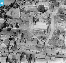
A great view of this famous old city from the south-east, featuring many of the historical landmarks which are still very much in evidence at the present day.
|
John Swain |
|
|
What a stunning photograph of this modernist style house which reflects the age.
|
Class31 |
|
|
This house featured in John Betjeman's 1973 wonderful and classis TV programme 'Metroland'
|
Chells809 |
|
|
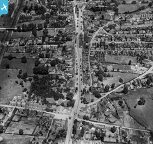
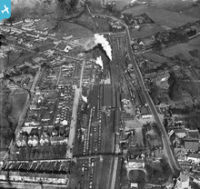
Hatfield is on the main east coast railway line, about 20 miles north of Kings Cross. The town was also on the line of the old Great North Road to Edinburgh. So here we see two major transport routes just a few yards apart (on the right side of the pic) In 1928 the town was a small country town in Hertfordshire though the pic shows what a large influence the railway had even in small communities for much of the 20th century.
Hatfield Station in this pic even had a private waiting room (if my memory is correct)for Lord Salisbury who lived in nearby Hatfield House (not on pic) and who used the train to go to London for his parliamentary business. Hatfield in those days was grouped around the station and the Great North Road, but it was expanding in the area to the left of the main line. After the war it really grew in size as one of London's New Towns. Also in this picture is the bus garage recently opened in 1922 by the National Omnibus & Transport Co on behalf of the London General. The General and National had entered into an agreement for National to develop services north of London on behalf of National. National provided the crews and General the garages and buses. So, for me this picture is full of transport interest showing the influence of the railway and the emerging influence of the motorbus (the bus garage is not there on an equivalent pic of 1920) |
Chells809 |
|
|
The photo also shows the Great North Road, a War Memorial and a statue together with more mundane features such as full washing lines which tends to indicate that the photo was taken on a Monday. So many steam locomotives and mainly coal wagons. The track layout has been much simplified today and power is mainly provided from the overhead electrical system. It is worthy of consideration.
|
Class31 |
|
|
A great image, including aircraft shadow on the road.
|
Katy Whitaker |
|
|
The shadow of the plane is quite sinister contrasting with bucolic village seen
|
Oliver Brookes |
|
|
What a stunning image of this iconic structure!
|
Class31 |
|
|
I just like the variety of shapes in this photo. The location is highly symbolic and is the back drop to the finish of the London Marathon. Technically it may not be perfect but the subject matter makes up for that.
|
Class31 |
|
|
Yes, this is a stunning image - and the wing detail gives a wonderful sense of context for the photographer
|
James Crawford |
|
|
I like the wing in shot too, it puts you in the air
|
Oliver Brookes |
|
|
I think that this a possible contender for the book as it shows the busy fishing port with drifters and Lowestoft Central Station in Great Eastern Railway days. The are tramlines and washing lines. There is even a swing bridge.
|
Class31 |
|
|
I love this photo of the terminus of the narrow gauge Leek & Manifold Light Railway which closed down shortly after this photo was taken.
|
Class31 |
|
|
In my view this is worthy of consideration.
|
Class31 |
|
|
I used to commute across this magnificent structure. It is such a wonderful picture.
|
Class31 |
|
|
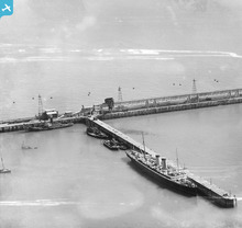
Unusual and surprising view of steamer from 1928.
|
James Crawford |
|
|
Evocative shot of RAF wing and Cairngorm plateau.
|
James Crawford |
|
|
Very early, yet very sharp image of St Paul's - excellent.
|
James Crawford |
|
|
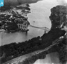
Sharp contrasty image of classic north Wales and Llanberis
|
Oliver Brookes |
|
|
Not sure if anyone can recognise the seventh Duke but its good to see the shadow of the aircraft. This image won't get in the book but if you find a great shadow image please post it up.
|
Oliver Brookes |
|
|
Grand view in good light, everything sitting neatly in the frame
|
Oliver Brookes |
|
|
Incredible shot of the R101 with Hyde Park below. Composition is wonderful.
|
James Crawford |
|
|
Love the cable system in the background - for transporting coal?
|
James Crawford |
|
|
This is a strange image almost as if its taken from the ground, I like the way the plane emerges from the grain, the marketing guy will hate it, but I think there is a font cover idea here.
|
Oliver Brookes |
|
|
Definitely not a front cover!
|
James Crawford |
|
|
He even looks a bit bored, brilliant image.
|
Oliver Brookes |
|
|
indeed! Who were these guys? Great photo, will bear in mind next time I am a bit anxious during a spot of turbulence...
|
Michela |
|
|
You really feel you are in the wind with these guys. The wing struts in shot and the sense of planes everywhere works very well to give this shot depth and interest.
|
Oliver Brookes |
|
|
The light really shows off the detail in this construction image. I like the close cropping of the towers and the busy quality of the subject.
|
Oliver Brookes |
|
|
Good light and a well composed image showing the power station in surprisingly a rural context, interesting to know what this looks like now.
|
Oliver Brookes |
|
|
I'll look forward to seeing a higher resolution image of this but it seems to show the power station in the context of the city in a very clear and dramatic scene.
|
Oliver Brookes |
|
|
Two kinds of power opposed to each other over the water. Not well enough composed or with good enough light to be a real contender. Odd though.
|
Oliver Brookes |
|
|
Maybe not a brilliant photo but the twinning of a power station and a sail barge makes quite poignant shot.
|
Oliver Brookes |
|
|
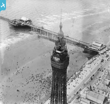
This has everything and sums up the excitement of Blackpool.
|
Oliver Brookes |
|
|
This is spectacular, you get a sense of how low they are.
|
Oliver Brookes |
|
|
I didn't see the stow away at first. Great shot.
|
Oliver Brookes |
|
|
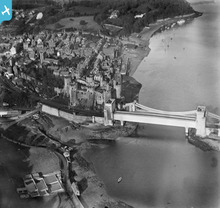
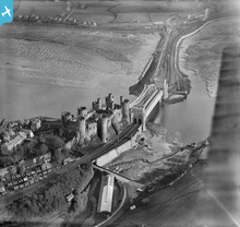
This is probably the best of the three Conwy castle images. It has really dynamic water and boats and the curve of the rails leads you into the towsncape and the horizon beyond
|
Oliver Brookes |
|
|
Maybe be this is better than the one below?
|
Oliver Brookes |
|
|
This image has everything, a castle, a bridge, a railway, the sea, all packed into one shot. Sometimes a bit of wing helps an image, here its maybe a distraction.
|
Oliver Brookes |
|
|
This image is just packed with life and activity. I like the way all the roads focus onto the head of the course. You get the sense of a really special occasion.
|
Oliver Brookes |
|
|
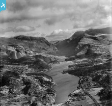
There is a perfect tranquility about this shot and a real sense of atmosphere with a good cloud scape. The light picking out the settlements on the island evokes the idea of a destination to a magical place and the island form itself is neatly framed.
|
Oliver Brookes |


The official publication date is 20 February 2014, when it will be available from all good booksellers. Look out for coverage in the national press as well!
Not to give anything away, but a number of your suggestions have made their way into the final layouts...