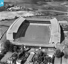
EPW049453 ENGLAND (1935). Twickenham Rugby Football Ground, Twickenham, 1935
© Copyright OpenStreetMap contributors and licensed by the OpenStreetMap Foundation. 2026. Cartography is licensed as CC BY-SA.
Nearby Images (22)
Details
| Title | [EPW049453] Twickenham Rugby Football Ground, Twickenham, 1935 |
| Reference | EPW049453 |
| Date | October-1935 |
| Link | |
| Place name | TWICKENHAM |
| Parish | |
| District | |
| Country | ENGLAND |
| Easting / Northing | 515320, 174305 |
| Longitude / Latitude | -0.34003926411566, 51.455475912062 |
| National Grid Reference | TQ153743 |
Pins
Be the first to add a comment to this image!
User Comment Contributions
A splendid view of the old stadium, which became the HQ of the Rugby Football Union and home to the England team from 1910, when the accommodation for spectators was only 30,000 and there was limited parking for motor vehicles. Necessary expansion took place after the Great War, with the completion of the North Stand (at the far end of the ground) in 1925, followed by extensions to the East and West Stands, so that there was now (1932) provision for 23,000 seated spectators in the two double-decker stands. Just three months after this photograph was taken, an estimated crowd of more than 73,000 witnessed the first-ever English victory over the New Zealand All Blacks by 13 points to nil, in what became known as Prince Obolensky's Match. The ground remained relatively unchanged until the 1980s and the refurbished stadium (capacity 82,000), arguably the most famous in the world, is set to host the Rugby World Cup Final in the autumn of 2015. A far cry from Edwardian times, when Billy Williams (1860-1950)discovered the market garden near the River Thames and was able to persuade the RFU to buy the site of ten acres, for the princely sum of £5,572 12s 6d!! |

John Swain |
Wednesday 15th of May 2013 06:37:22 PM |


![[EPW049453] Twickenham Rugby Football Ground, Twickenham, 1935](http://britainfromabove.org.uk/sites/all/libraries/aerofilms-images/public/100x100/EPW/049/EPW049453.jpg)
![[EPW025839] Twickenham, the annual Army Navy rugby union match, 1929](http://britainfromabove.org.uk/sites/all/libraries/aerofilms-images/public/100x100/EPW/025/EPW025839.jpg)
![[EPR000638] Twickenham Rugby Football Ground, Twickenham, 1935](http://britainfromabove.org.uk/sites/all/libraries/aerofilms-images/public/100x100/EPR/000/EPR000638.jpg)
![[EPW025843] Twickenham, the annual Army Navy rugby union match, 1929](http://britainfromabove.org.uk/sites/all/libraries/aerofilms-images/public/100x100/EPW/025/EPW025843.jpg)
![[EPW023249] Twickenham Rugby Stadium, Twickenham, 1928](http://britainfromabove.org.uk/sites/all/libraries/aerofilms-images/public/100x100/EPW/023/EPW023249.jpg)
![[EPW025842] Twickenham, the annual Army Navy rugby union match, 1929](http://britainfromabove.org.uk/sites/all/libraries/aerofilms-images/public/100x100/EPW/025/EPW025842.jpg)
![[EPW025840] Twickenham, the annual Army Navy rugby union match, 1929](http://britainfromabove.org.uk/sites/all/libraries/aerofilms-images/public/100x100/EPW/025/EPW025840.jpg)
![[EPW049454] Twickenham Rugby Football Ground, Twickenham, 1935](http://britainfromabove.org.uk/sites/all/libraries/aerofilms-images/public/100x100/EPW/049/EPW049454.jpg)
![[EPW022945] Twickenham Rugby Football Ground, Twickenham, 1928](http://britainfromabove.org.uk/sites/all/libraries/aerofilms-images/public/100x100/EPW/022/EPW022945.jpg)
![[EPW025841] Twickenham, the annual Army Navy rugby union match, 1929](http://britainfromabove.org.uk/sites/all/libraries/aerofilms-images/public/100x100/EPW/025/EPW025841.jpg)
![[EPW025845] Twickenham, the annual Army Navy rugby union match, 1929](http://britainfromabove.org.uk/sites/all/libraries/aerofilms-images/public/100x100/EPW/025/EPW025845.jpg)
![[EPW049447] Twickenham Rugby Football Ground, Twickenham, 1935](http://britainfromabove.org.uk/sites/all/libraries/aerofilms-images/public/100x100/EPW/049/EPW049447.jpg)
![[EPW049455] Twickenham Rugby Football Ground, Twickenham, 1935](http://britainfromabove.org.uk/sites/all/libraries/aerofilms-images/public/100x100/EPW/049/EPW049455.jpg)
![[EPW025844] Twickenham, the annual Army Navy rugby union match, 1929](http://britainfromabove.org.uk/sites/all/libraries/aerofilms-images/public/100x100/EPW/025/EPW025844.jpg)
![[EPW049446] Twickenham Rugby Football Ground, Twickenham, 1935](http://britainfromabove.org.uk/sites/all/libraries/aerofilms-images/public/100x100/EPW/049/EPW049446.jpg)
![[EPW049449] Twickenham Rugby Football Ground, Twickenham, 1935](http://britainfromabove.org.uk/sites/all/libraries/aerofilms-images/public/100x100/EPW/049/EPW049449.jpg)
![[EPW017385] Twickenham Rugby Football Ground, Twickenham, 1927](http://britainfromabove.org.uk/sites/all/libraries/aerofilms-images/public/100x100/EPW/017/EPW017385.jpg)
![[EPW049451] Twickenham Rugby Football Ground, Twickenham, 1935](http://britainfromabove.org.uk/sites/all/libraries/aerofilms-images/public/100x100/EPW/049/EPW049451.jpg)
![[EPW049450] Twickenham Rugby Football Ground and environs, Twickenham, from the south, 1935](http://britainfromabove.org.uk/sites/all/libraries/aerofilms-images/public/100x100/EPW/049/EPW049450.jpg)
![[EPW049452] Twickenham Rugby Football Ground, Twickenham, 1935](http://britainfromabove.org.uk/sites/all/libraries/aerofilms-images/public/100x100/EPW/049/EPW049452.jpg)
![[EPW049448] Twickenham Rugby Football Ground, Twickenham, 1935](http://britainfromabove.org.uk/sites/all/libraries/aerofilms-images/public/100x100/EPW/049/EPW049448.jpg)
![[EPW034843] Twickenham Rugby Football Ground, Twickenham, 1931. This image has been produced from a damaged negative.](http://britainfromabove.org.uk/sites/all/libraries/aerofilms-images/public/100x100/EPW/034/EPW034843.jpg)
