
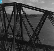
SAW014846 SCOTLAND (1948). Forth Rail Bridge and Dalgety Bay, Firth of Forth. An oblique aerial photograph taken facing north-east. This image has been produced from a print.

© Copyright OpenStreetMap contributors and licensed by the OpenStreetMap Foundation. 2026. Cartography is licensed as CC BY-SA.
Nearby Images (4)
SAW014846

SAW014844

SAW014845

SAW052275

Details
| Title | [SAW014846] Forth Rail Bridge and Dalgety Bay, Firth of Forth. An oblique aerial photograph taken facing north-east. This image has been produced from a print. |
| Reference | SAW014846 |
| Date | 1948 |
| Link | NRHE Collection item 1314757 |
| Place name | |
| Parish | INVERKEITHING |
| District | DUNFERMLINE |
| Country | SCOTLAND |
| Easting / Northing | 313468, 680254 |
| Longitude / Latitude | -3.3878986491214, 56.007450192629 |
| National Grid Reference | NT135803 |
Pins
Be the first to add a comment to this image!
User Comment Contributions
Some seriously low flying here - the iconic Forth Bridge from 1948 |

James Crawford |
Wednesday 14th of August 2013 02:02:45 PM |
Good thing that Aerofilms Ltd made a print - I saw the original negative when we were planning how to handle the nitrate film material that has undergone serious chemical change. It is just about possible to make out the ironwork, but the degredation was awful... |
Katy Whitaker |
Wednesday 14th of August 2013 02:02:45 PM |