Skip to main content
Prydain oddi Fry
Cymraeg
|
English
Mewngofnod
|
Cofrestru
Toggle navigation
Hafan
Gwaddol
Ynghylch
Map
Orielau
Grwpiau
Cymorth
Chwilio
Pob Gwlad (96344)
Lloegr (82521)
Yr Alban (6398)
Cymru (4321)
Gweddill y Byd (3104)
Gwlad Belg (7)
Ffrainc (27)
yr Almaen (2)
Guernsey (116)
Iran (8)
Irac (6)
Iwerddon (1466)
Ynys Manaw (75)
Jersey (122)
yr Iseldiroedd (20)
Northern Ireland (1163)
Sbaen (9)
y Swisdir (26)
Gweithgaredd Diweddaraf
Saved Images
Pagination
First page
first
Previous page
previous
…
Tudalen
9
Tudalen
10
Tudalen
11
Tudalen
12
Current page
13
Tudalen
14
Tudalen
15
Tudalen
16
Tudalen
17
…
Next page
next
Last page
last
[SPW040233] Old Blacksmith's Shop, Bensmoor Road, Springfield. An oblique aerial photograph taken facing north.
[SPW048771] John Brown's Shipyard, Clydebank, Queen Mary under construction. An oblique aerial photograph taken facing south-west.
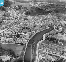
[EPW026538] The town centre, Kendal, from the south, 1929
[EPW026537] The town centre, Kendal, from the south-east, 1929
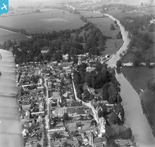
[EPW000896] View over Wallingford from the Kine Croft, from the west, 1920
[EPW000898] St Leonard's Church, the cattle market, and St Peter's Church area of Wallingford, Wallingford, 1920
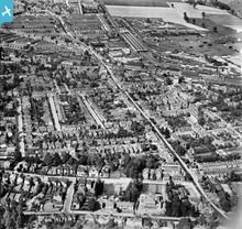
[EPW021399] St Albans Road and Watford Junction, Watford, 1928
[EPW019235] Cassiobury Park and Watford Railway Station, West Watford, 1927
Pagination
First page
first
Previous page
previous
…
Tudalen
9
Tudalen
10
Tudalen
11
Tudalen
12
Current page
13
Tudalen
14
Tudalen
15
Tudalen
16
Tudalen
17
…
Next page
next
Last page
last
This user has had no activity in the last year.