
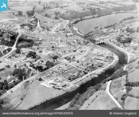
XPW043559 IRELAND (1933). General View, Enniscorthy, Wexford, Ireland, 1933. Oblique aerial photograph taken facing North.
© Hawlfraint cyfranwyr OpenStreetMap a thrwyddedwyd gan yr OpenStreetMap Foundation. 2026. Trwyddedir y gartograffeg fel CC BY-SA.
Delweddau cyfagos (2)
XPW043559

XPW043557

Manylion
| Pennawd | [XPW043559] General View, Enniscorthy, Wexford, Ireland, 1933. Oblique aerial photograph taken facing North. |
| Cyfeirnod | XPW043559 |
| Dyddiad | 1933 |
| Dolen | |
| Enw lle | ENNISCORTHY |
| Plwyf | IRELAND |
| Ardal | |
| Gwlad | IRELAND |
| Dwyreiniad / Gogleddiad | 90091, 299036 |
| Hydred / Lledred | -6.56796, 52.500911 |
| Cyfeirnod Grid Cenedlaethol |
Pinnau

John Swain |
Tuesday 7th of October 2014 03:03:07 PM | |
|
John Swain |
Tuesday 7th of October 2014 03:01:44 PM | |
|
John Swain |
Tuesday 7th of October 2014 03:01:01 PM | |
|
John Swain |
Tuesday 7th of October 2014 03:00:13 PM | |
|
John Swain |
Tuesday 7th of October 2014 02:58:12 PM | |
|
John Swain |
Tuesday 7th of October 2014 02:56:59 PM | |
|
John Swain |
Tuesday 7th of October 2014 02:55:36 PM | |
|
John Swain |
Tuesday 7th of October 2014 02:54:42 PM | |
|
John Swain |
Tuesday 7th of October 2014 02:54:13 PM |
Cyfraniadau Grŵp
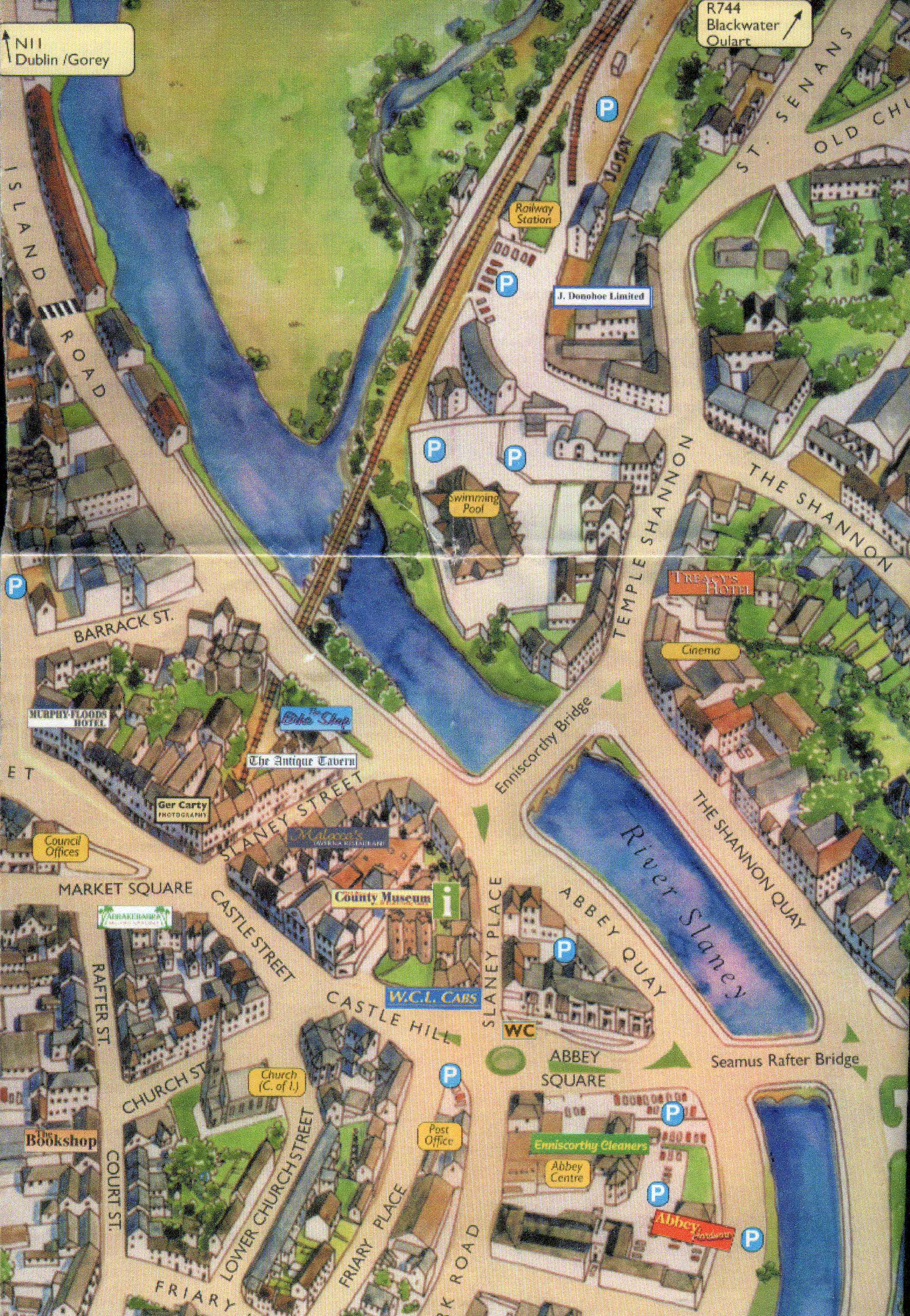
Town map of Enniscorthy showing some of the medieval streets and railway station, by Condor Publications, 2000. |
John Swain |
Monday 13th of October 2014 01:26:03 PM |
The historic and attractive town of Enniscorthy (population around 5,800 at the time of this photograph) is considered to be one of Ireland's Country Towns, along with the likes of Kells, Maynooth, Bandon, Castlecomer, Bray, Sligo, Athlone, Mullingar and Dungarvan. The town grew up at a crossing point over the River Slaney, approximately at the river's tidal limit. The name itself is derived from the Gaelic, Inis Coirthe (Corthaidh on modern maps), quite literally Coirthe's Island, a boat-shaped island in the Slaney above the current Enniscorthy Bridge. The town's early growth was promoted by the invading Normans and a castle was built on a rocky outcrop overlooking the river crossing. However, the present layout of the town did not begin to take shape until after the mid-17th century, when the population exceeded 1,000 for the first time, of which 16% were classed as English. Enniscorthy reached its maximum size in 1841 (7,000) and, despite the impact of the Great Hunger in the later 1840s, the coming of the railway in 1863 enhanced the industrial growth of the town (corn milling, bacon curing, mineral waters). Great brick, Victorian warehouses now lined the quays and may be seen in these images. Several have since been destroyed or have changed function in the late 20th and early 21st centuries. Ref: Irish Country Towns, edited by Simms & Andrews, Mercier Press 1994. |
John Swain |
Tuesday 7th of October 2014 03:28:58 PM |