
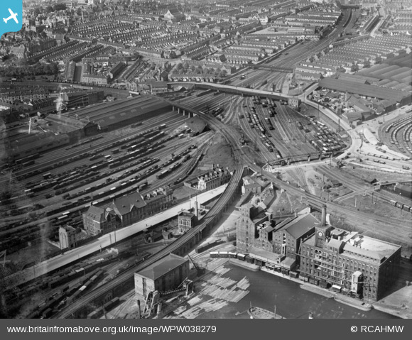
WPW038279 WALES (1932). View of Bute area of Cardiff, oblique aerial view. 5"x4" black and white glass plate negative.
© Hawlfraint cyfranwyr OpenStreetMap a thrwyddedwyd gan yr OpenStreetMap Foundation. 2026. Trwyddedir y gartograffeg fel CC BY-SA.
Delweddau cyfagos (48)
WPW001000

WPW001001

WPW001002

WPW001003

WPW001004

WPW001008

WPW001009

WPW001010

WPW001014

WPW001035

WPW016914

WPW016915

WPW016916

WPW016917

WPW016918

WPW016919

WPW016920

WPW029422

WPW029423

WPW029424

WPW029425

WPW029427

WPW029429

WPW041787

WPW041788

WPW041789

WPW041790

WPW041791

WPW041792

WPW041793

WPW041794

WPW041795

WPW052624

WPW052659

WPW052660

WPW052661

WPW052662

WPW052663

WPW052664

WPW054861

WPW054863

WPW054864

WPW054865

WPW055450

WPW055451

WPW055452

WPW055453

WPW055454

Manylion
| Pennawd | [WPW038279] View of Bute area of Cardiff, oblique aerial view. 5"x4" black and white glass plate negative. |
| Cyfeirnod | WPW038279 |
| Dyddiad | 1932 |
| Dolen | Coflein Archive Item 6370899 |
| Enw lle | |
| Plwyf | |
| Ardal | |
| Gwlad | WALES |
| Dwyreiniad / Gogleddiad | 318170, 176360 |
| Hydred / Lledred | -3.1785006478589, 51.479784917149 |
| Cyfeirnod Grid Cenedlaethol | ST182764 |
Pinnau

Class31 |
Monday 28th of July 2014 05:09:36 PM | |
|
Class31 |
Monday 28th of July 2014 05:09:15 PM | |
|
Class31 |
Monday 28th of July 2014 05:08:53 PM | |

gBr |
Monday 21st of July 2014 08:52:06 PM | |
|
gBr |
Monday 21st of July 2014 08:44:41 PM | |
|
gBr |
Monday 21st of July 2014 08:41:18 PM | |
|
gBr |
Monday 21st of July 2014 08:27:21 PM | |
|
gBr |
Monday 21st of July 2014 08:20:55 PM | |
|
gBr |
Monday 21st of July 2014 08:13:46 PM | |
|
Brannkouk |
Saturday 23rd of March 2013 03:58:17 PM | |
|
MB |
Saturday 13th of October 2012 11:22:22 AM | |
|
MB |
Saturday 13th of October 2012 11:20:48 AM | |
GWR Newtown Goods depot |
gBr |
Monday 21st of July 2014 08:29:59 PM |
|
MB |
Saturday 13th of October 2012 11:20:13 AM | |
|
MB |
Saturday 13th of October 2012 11:19:47 AM | |
|
MB |
Saturday 13th of October 2012 11:18:12 AM | |
|
MB |
Saturday 13th of October 2012 11:16:50 AM | |
|
MB |
Saturday 13th of October 2012 11:15:22 AM | |
|
MB |
Saturday 13th of October 2012 11:14:16 AM | |
|
MB |
Saturday 13th of October 2012 11:13:07 AM | |
|
MB |
Saturday 13th of October 2012 11:12:42 AM | |
|
MB |
Saturday 13th of October 2012 11:12:17 AM | |
|
MB |
Saturday 13th of October 2012 11:11:48 AM | |
|
MB |
Saturday 13th of October 2012 11:03:22 AM | |
|
Allan |
Sunday 29th of July 2012 02:24:06 PM | |
|
Allan |
Sunday 29th of July 2012 02:23:41 PM | |
|
Allan |
Sunday 29th of July 2012 02:23:00 PM | |
|
Allan |
Sunday 29th of July 2012 02:22:26 PM | |
|
Chelsea61 |
Friday 29th of June 2012 11:42:09 PM | |
|
Cannon |
Friday 29th of June 2012 10:09:22 PM | |
|
Cannon |
Friday 29th of June 2012 10:07:04 PM |
Cyfraniadau Grŵp
Could someone explain why this is referred to as the "Bute" area? It isn't Bute Town, and my understanding was that the land in this part of town was owned by the Morgans of Tredegar Park rather than the Bute family. |
gBr |
Monday 21st of July 2014 08:39:35 PM |
Top Centre:- Adamsdown with Cardiff Royal Infirmary in the very top left hand. Quarter of the way down on the left is Cardiff Prison and the long bridge over the railway (right) is the one that links the area near the prison with the old 'timber' area (John Blands etc) and East Moors Road. The turning to the Left at the end of the bridge is Sanquahar Street with goes to Splott. Just above the railway bridge is the pedestrian bridge from Adamsdown to Sanquahar St.. The big road to the bottom left is Tyndal Street |
Siggy708 |
Monday 21st of July 2014 08:34:43 PM |
I don't think the Prison quite makes it into this shot. The Rhymney Rly bridge over Adam Street isn't in the frame and HMP is west of that. |
gBr |
Monday 21st of July 2014 08:34:43 PM |
Adamsdown, Roath, Splott. View of Bute area of Cardiff |

BillySastard |
Thursday 9th of May 2013 02:36:20 PM |
My preferred Easting/Northing here would be 319070, 175896 |
MB |
Saturday 13th of October 2012 11:23:56 AM |
Good view of a steam-powered bucket dredger, foreground |
MB |
Saturday 13th of October 2012 11:05:55 AM |