
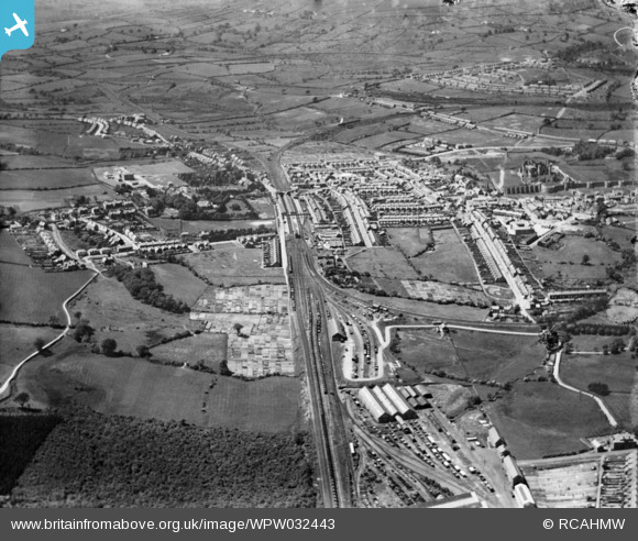
WPW032443 WALES (1930). General view of Caerphilly, oblique aerial view. 5"x4" black and white glass plate negative.
© Hawlfraint cyfranwyr OpenStreetMap a thrwyddedwyd gan yr OpenStreetMap Foundation. 2026. Trwyddedir y gartograffeg fel CC BY-SA.
Delweddau cyfagos (33)
WAW007641

WAW007642

WAW007643

WAW007644

WAW007647

WAW018008

WAW018009

WAW018010

WAW018660

WAW018661

WAW018662

WAW018663

WAW018664

WAW018665

WAW018666

WAW018667

WAW018668

WPW013836

WPW032443

WPW032444

WPW032445

WPW032447

WPW050477

WPW050478

WPW050479

WPW050481

WPW050482

WAW005950

WAW005951

WAW005952

WAW005953

WAW005954

WAW005955

Manylion
| Pennawd | [WPW032443] General view of Caerphilly, oblique aerial view. 5"x4" black and white glass plate negative. |
| Cyfeirnod | WPW032443 |
| Dyddiad | 1930 |
| Dolen | Coflein Archive Item 6370760 |
| Enw lle | |
| Plwyf | |
| Ardal | |
| Gwlad | WALES |
| Dwyreiniad / Gogleddiad | 315700, 186920 |
| Hydred / Lledred | -3.2165926156352, 51.574361161326 |
| Cyfeirnod Grid Cenedlaethol | ST157869 |
Pinnau

Handymanathome |
Monday 30th of March 2020 04:02:47 PM | |
|
Penrhos1920 |
Thursday 21st of March 2013 07:15:46 PM | |
|
Penrhos1920 |
Thursday 21st of March 2013 07:12:19 PM | |
|
Penrhos1920 |
Thursday 21st of March 2013 07:10:58 PM | |
|
Penrhos1920 |
Thursday 21st of March 2013 07:09:46 PM | |
|
pratjeffley |
Wednesday 19th of September 2012 02:22:38 AM | |
|
pratjeffley |
Wednesday 19th of September 2012 02:17:54 AM | |
|
pratjeffley |
Wednesday 19th of September 2012 02:14:38 AM | |
I think these were the carriage & wagon shops, replaced before WW2 by new buildings. The loco shops are just barely in view at bottom of picture |
gBr |
Saturday 26th of September 2015 08:10:23 PM |
|
pratjeffley |
Wednesday 19th of September 2012 02:09:38 AM | |
|
johnabutt |
Saturday 7th of July 2012 03:27:32 PM | |
This is actually a footpath (which still exists) linking Nant-y-calch Farm to the area locally known as 'The Clay Pits'--the area south of the Wernddu brickworks. |
pratjeffley |
Wednesday 19th of September 2012 02:06:02 AM |
|
johnabutt |
Saturday 7th of July 2012 03:26:35 PM |
Cyfraniadau Grŵp

Van Road, Caerphilly, 25/09/2015 |

Class31 |
Sunday 27th of September 2015 12:00:15 PM |