
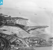
WPW029400 WALES (1929). View of Cold Knap Point, Barry, oblique aerial view. 5"x4" black and white glass plate negative.

© Hawlfraint cyfranwyr OpenStreetMap a thrwyddedwyd gan yr OpenStreetMap Foundation. 2026. Trwyddedir y gartograffeg fel CC BY-SA.
Delweddau cyfagos (15)
WPW006090

WPW006093

WPW006094

WPW006096

WPW008635

WPW024955A

WPW029392

WPW029399

WPW029400

WPW029456

WPW029458

WPW029459

WPW029461

WPW029462

WPW041252

Manylion
| Pennawd | [WPW029400] View of Cold Knap Point, Barry, oblique aerial view. 5"x4" black and white glass plate negative. |
| Cyfeirnod | WPW029400 |
| Dyddiad | 1929 |
| Dolen | Coflein Archive Item 6378043 |
| Enw lle | |
| Plwyf | |
| Ardal | |
| Gwlad | WALES |
| Dwyreiniad / Gogleddiad | 311000, 166000 |
| Hydred / Lledred | -3.2791309458519, 51.385561791936 |
| Cyfeirnod Grid Cenedlaethol | ST110660 |
Pinnau

Paul Baker |
Wednesday 15th of October 2014 07:49:22 PM | |
|
trelissick |
Saturday 8th of June 2013 09:25:47 PM | |
|
trelissick |
Saturday 8th of June 2013 08:58:23 PM | |
|
trelissick |
Saturday 8th of June 2013 08:54:59 PM | |
|
trelissick |
Wednesday 5th of June 2013 07:14:39 PM | |
|
trelissick |
Wednesday 5th of June 2013 07:12:42 PM | |
|
trelissick |
Wednesday 5th of June 2013 07:11:01 PM | |
|
kent2 |
Tuesday 9th of October 2012 09:33:46 AM | |
|
kent2 |
Tuesday 9th of October 2012 09:32:28 AM | |
|
kent2 |
Tuesday 9th of October 2012 09:31:34 AM |
Cyfraniadau Grŵp
Barry Island |
Brian Wilkinson |
Friday 25th of May 2012 03:34:55 PM |