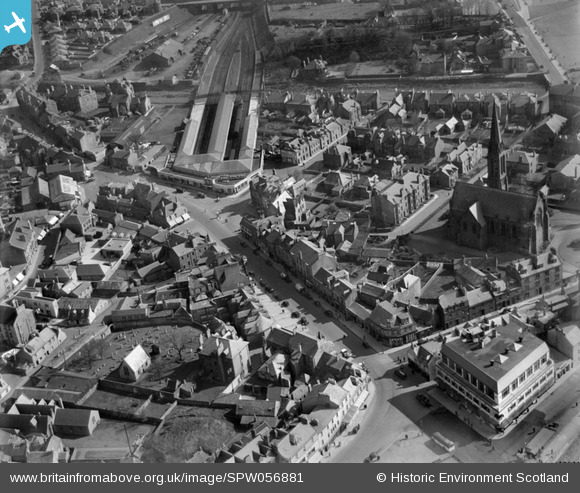
SPW056881 SCOTLAND (1938). Largs, general view, showing Main Street and Largs Station. An oblique aerial photograph taken facing south.
    © Hawlfraint cyfranwyr OpenStreetMap a thrwyddedwyd gan yr OpenStreetMap Foundation. 2025. Trwyddedir y gartograffeg fel CC BY-SA.
  
Delweddau cyfagos (21)
Manylion
| Pennawd | [SPW056881] Largs, general view, showing Main Street and Largs Station. An oblique aerial photograph taken facing south. | 
| Cyfeirnod | SPW056881 | 
| Dyddiad | 1938 | 
| Dolen | NRHE Collection item 1258233 | 
| Enw lle | |
| Plwyf | LARGS | 
| Ardal | CUNNINGHAME | 
| Gwlad | SCOTLAND | 
| Dwyreiniad / Gogleddiad | 220261, 659313 | 
| Hydred / Lledred | -4.8673815811269, 55.793650618978 | 
| Cyfeirnod Grid Cenedlaethol | NS203593 | 
Pinnau
|   Billy Turner | Monday 24th of October 2016 07:49:12 PM | |
|  The train crash on 11 July 1995 when the front carriage blasted through the buffers, two buildings, before coming to a shuddering halt on Largs Main Street's taxi rank. |   Billy Turner | Monday 24th of October 2016 07:28:43 PM | 
|  Clark Memorial Church |   threetowner | Monday 16th of June 2014 09:41:34 PM | 
|  Skelmorlie Aisle |   thomasmann | Monday 27th of August 2012 02:14:38 PM | 
|  The Moorings, a famous restaurant and ballroom |   thomasmann | Monday 27th of August 2012 02:14:05 PM | 
|  LMS (formerly GSWR} terminus Railway Station |   thomasmann | Monday 27th of August 2012 02:13:20 PM | 
 
             
  ![[SPW056881] Largs, general view, showing Main Street and Largs Station.  An oblique aerial photograph taken facing south.](http://britainfromabove.org.uk/sites/all/libraries/aerofilms-images/public/100x100/SPW/056/SPW056881.jpg) 
  
                                          ![[SPW056877] Largs, general view, showing Clark Memorial Church, Bath Street and Boyd Street.  An oblique aerial photograph taken facing north-east.  This image has been produced from a print.](http://britainfromabove.org.uk/sites/all/libraries/aerofilms-images/public/100x100/SPW/056/SPW056877.jpg) 
 ![[SPW019554] Largs, general view, showing Main Street and Largs Station.  An oblique aerial photograph taken facing east.](http://britainfromabove.org.uk/sites/all/libraries/aerofilms-images/public/100x100/SPW/019/SPW019554.jpg) 
 ![[SPW056878] Largs, general view, showing Clark Memorial Church, Bath Street and Largs Pier.  An oblique aerial photograph taken facing east.  This image has been produced from a print.](http://britainfromabove.org.uk/sites/all/libraries/aerofilms-images/public/100x100/SPW/056/SPW056878.jpg) 
 ![[SPW019553] Largs, general view, showing Clark Memorial Church and Promenade.  An oblique aerial photograph taken facing north.](http://britainfromabove.org.uk/sites/all/libraries/aerofilms-images/public/100x100/SPW/019/SPW019553.jpg) 
 ![[SPW019555] Largs, general view, showing Clark Memorial Church and Main Street.  An oblique aerial photograph taken facing east.](http://britainfromabove.org.uk/sites/all/libraries/aerofilms-images/public/100x100/SPW/019/SPW019555.jpg) 
 ![[SAR014822] Pier and Steamer Largs, Ayrshire, Scotland. An oblique aerial photograph taken facing North/East. This image was marked by AeroPictorial Ltd for photo editing.](http://britainfromabove.org.uk/sites/all/libraries/aerofilms-images/public/100x100/SAR/014/SAR014822.jpg) 
 ![[SAR014823] General view of seafront Largs, Ayrshire, Scotland. An oblique aerial photograph taken facing South.](http://britainfromabove.org.uk/sites/all/libraries/aerofilms-images/public/100x100/SAR/014/SAR014823.jpg) 
 ![[SAR014824] General view Largs, Ayrshire, Scotland. An oblique aerial photograph taken facing North/East. This image was marked by AeroPictorial Ltd for photo editing.](http://britainfromabove.org.uk/sites/all/libraries/aerofilms-images/public/100x100/SAR/014/SAR014824.jpg) 
 ![[SAR014825] General view Largs, Ayrshire, Scotland. An oblique aerial photograph taken facing North/East. This image was marked by AeroPictorial Ltd for photo editing.](http://britainfromabove.org.uk/sites/all/libraries/aerofilms-images/public/100x100/SAR/014/SAR014825.jpg) 
 ![[SAR027694] General View Largs, Ayrshire, Scotland. An oblique aerial photograph taken facing South. This image was marked by AeroPictorial Ltd for photo editing.](http://britainfromabove.org.uk/sites/all/libraries/aerofilms-images/public/100x100/SAR/027/SAR027694.jpg) 
 ![[SAR027695] General View Largs, Ayrshire, Scotland. An oblique aerial photograph taken facing South.](http://britainfromabove.org.uk/sites/all/libraries/aerofilms-images/public/100x100/SAR/027/SAR027695.jpg) 
 ![[SAR027696] General View Largs, Ayrshire, Scotland. An oblique aerial photograph taken facing South/East. This image was marked by AeroPictorial Ltd for photo editing.](http://britainfromabove.org.uk/sites/all/libraries/aerofilms-images/public/100x100/SAR/027/SAR027696.jpg) 
 ![[SAR027697] General View Largs, Ayrshire, Scotland. An oblique aerial photograph taken facing East. This image was marked by AeroPictorial Ltd for photo editing.](http://britainfromabove.org.uk/sites/all/libraries/aerofilms-images/public/100x100/SAR/027/SAR027697.jpg) 
 ![[SAR031667] Looking to Isle of Arran Largs, Ayrshire, Scotland. An oblique aerial photograph taken facing West.](http://britainfromabove.org.uk/sites/all/libraries/aerofilms-images/public/100x100/SAR/031/SAR031667.jpg) 
 ![[SAW039354] Largs, general view, showing Largs Harbour and Clark Memorial Church, Bath Street.  An oblique aerial photograph taken facing north-east.  This image has been produced from a print.](http://britainfromabove.org.uk/sites/all/libraries/aerofilms-images/public/100x100/SAW/039/SAW039354.jpg) 
 ![[SPW019557] Largs, general view, showing Mackerston Place and Largs Station.  An oblique aerial photograph taken facing north.  This image has been produced from a print.](http://britainfromabove.org.uk/sites/all/libraries/aerofilms-images/public/100x100/SPW/019/SPW019557.jpg) 
 ![[SPW056880] Largs, general view, showing Brisbane Road and Lovat Street.  An oblique aerial photograph taken facing north.](http://britainfromabove.org.uk/sites/all/libraries/aerofilms-images/public/100x100/SPW/056/SPW056880.jpg) 
 ![[SAW039355] Largs, general view, showing Largs Harbour and Nelson Street.  An oblique aerial photograph taken facing east.  This image has been produced from a print.](http://britainfromabove.org.uk/sites/all/libraries/aerofilms-images/public/100x100/SAW/039/SAW039355.jpg) 
 ![[SPW056873] Largs, general view, showing St Columba's Parish Church, Gallowgate Street and Gallowgate Lane.  An oblique aerial photograph taken facing east.  This image has been produced from a print.](http://britainfromabove.org.uk/sites/all/libraries/aerofilms-images/public/100x100/SPW/056/SPW056873.jpg) 
 ![[SPW019556] Largs Harbour Pier.  An oblique aerial photograph taken facing east.](http://britainfromabove.org.uk/sites/all/libraries/aerofilms-images/public/100x100/SPW/019/SPW019556.jpg) 
 
