
SPW051068 SCOTLAND (1936). Dunure Castle, Maybole. An oblique aerial photograph taken facing east. This image has been produced from a damaged negative.

© Hawlfraint cyfranwyr OpenStreetMap a thrwyddedwyd gan yr OpenStreetMap Foundation. 2026. Trwyddedir y gartograffeg fel CC BY-SA.
Manylion
| Pennawd | [SPW051068] Dunure Castle, Maybole. An oblique aerial photograph taken facing east. This image has been produced from a damaged negative. |
| Cyfeirnod | SPW051068 |
| Dyddiad | 1936 |
| Dolen | NRHE Collection item 1258091 |
| Enw lle | |
| Plwyf | MAYBOLE |
| Ardal | KYLE AND CARRICK |
| Gwlad | SCOTLAND |
| Dwyreiniad / Gogleddiad | 225229, 615821 |
| Hydred / Lledred | -4.7606633633375, 55.405096894958 |
| Cyfeirnod Grid Cenedlaethol | NS252158 |
Pinnau

iainlapsley |
Tuesday 26th of June 2012 07:03:02 AM | |
|
Alan McFarlane |
Thursday 14th of June 2012 07:56:03 PM |
Cyfraniadau Grŵp

This castle is famous for 'The Roasting of the Commendator of Crossraguel'! http://www.maybole.org/history/books/placesofinterest/dunurecastle.htm http://www.maybole.org/history/books/legends/roastingofthecommendator.htm |
Alan McFarlane |
Monday 25th of June 2012 11:32:06 PM |
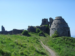
An interesting item at Dunure is the Doocot, or Dovecot that stands beside the castle, this would have provided fresh meat for the family. |

TrevorD |
Monday 25th of June 2012 11:32:06 PM |