
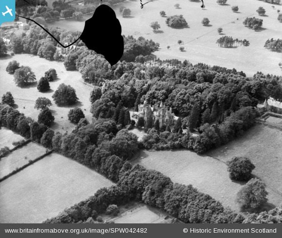
SPW042482 SCOTLAND (1933). Siverbuthall House. An oblique aerial photograph. This image has been produced from a damaged negative.
© Hawlfraint cyfranwyr OpenStreetMap a thrwyddedwyd gan yr OpenStreetMap Foundation. 2026. Trwyddedir y gartograffeg fel CC BY-SA.
Manylion
| Pennawd | [SPW042482] Siverbuthall House. An oblique aerial photograph. This image has been produced from a damaged negative. |
| Cyfeirnod | SPW042482 |
| Dyddiad | 1933 |
| Dolen | NRHE Collection item 1257944 |
| Enw lle | |
| Plwyf | HAWICK |
| Ardal | ROXBURGH |
| Gwlad | SCOTLAND |
| Dwyreiniad / Gogleddiad | 350393, 615790 |
| Hydred / Lledred | -2.784049454582, 55.433464002417 |
| Cyfeirnod Grid Cenedlaethol | NT504158 |
Pinnau

Project Hawick |
Wednesday 12th of February 2014 01:52:52 PM | |
|
slowcoach |
Saturday 23rd of November 2013 12:59:46 AM | |
|
Graeme |
Sunday 17th of November 2013 08:23:03 AM | |
|
Graeme |
Sunday 17th of November 2013 08:06:47 AM | |
|
Graeme |
Sunday 17th of November 2013 08:04:02 AM | |
|
Graeme |
Sunday 17th of November 2013 08:03:14 AM | |
|
Graeme |
Sunday 17th of November 2013 07:51:24 AM | |
|
Graeme |
Sunday 17th of November 2013 07:49:40 AM | |
|
Graeme |
Sunday 17th of November 2013 07:48:36 AM | |
|
Graeme |
Sunday 17th of November 2013 07:47:43 AM | |
|
Graeme |
Sunday 17th of November 2013 07:45:14 AM | |
|
historyfan |
Thursday 8th of August 2013 04:47:55 PM | |
|
BigglesH |
Sunday 7th of July 2013 02:03:47 AM | |
|
BigglesH |
Sunday 7th of July 2013 02:02:40 AM | |
|
BigglesH |
Sunday 7th of July 2013 02:01:27 AM | |
|
Muc |
Sunday 30th of June 2013 10:18:31 PM |
Cyfraniadau Grŵp
This area of Hawick was previously known as the 'Easter Heip', a name in use since the mid-17th century to describe the surrounding estate. During the 18th century, the 'Silverbuthall' name came into use - which refers to the location of Wilton Parish's archery targets or 'butts', and the tradition of having a silver arrow as a competition prize. The name was corrupted over time, shown in various records as 'Sillerbithaa' or 'Sillerbit Ha', to become Silverbuthall. Sillerbit Hall itself, was a large mansion house built on farm land, bought by Thomas Laidlaw (tweed manufacturer and owner of William Laidlaw & Sons), from Walter Wilson in 1861. It was designed in a Scots Baronial style by John Thomas Rochead, who was also responsible for Hillhead House, Langlands Park, Hawick Corn Exchange (now the site of the Heritage Hub), Heronhill, Thornwood House (now the Mansfield House Hotel) and Saint Andrew's Free Church on North Bridge Street. The house was constructed between 1863 and 1866, with a new driveway created along what is now Churchill Road. The Rochead-designed gate house and piers still stand today on Havelock Street - the yellow sandstone piers with indents where the large wrought iron gates were once held into place. During WWI, the mansion was used by Belgian refugees. The sprawling hillside estate was bought by Hawick Town Council in 1945, with the mansion demolished a year later, being affected greatly by dry rot. A window panel from the house survives in Hawick Museum, whilst stained glass representations of William Of Deloraine and Henry Of Cranstoun (both fictional characters in Walter Scott novels) were saved and until recently were on display at Drumlanrig's Tower. Hawick Museum also holds a wedge-shaped perforated hammer of rough surfaced sandstone, which was found on the estate by J. Anderson and G. F. Black, in 1888. Silverbuthall estate helped to solve Hawick's post-WWII housing shortage. The first 90 ''prefab' homes were erected between 1945 and 1947, with more built in the following years - compensating for a lack of natural building materials available at the time. Prefabricated homes were a specialist dwelling manufactured off-site in advance, usually in standard sections that could be easily shipped and assembled. They consisted of a mixture of 'Arco' and 'Uni-Seco' types. The 'Arco' was developed and constructed by Taylor Woodrow, as an asbestos-clad kitchen and bathroom capsule. It had a longer utility life, but came with a higher cost of construction per unit. Produced by the London based Selection Engineering Company Ltd., the 'Uni-Seco' was a two-bedroom flat-roofed bungalow, with a resin-bonded plywood timber-frame and asbestos wall sections. It was based on a military wartime office design, with an additional lounge and side door. The last of Hawick's prefabs were demolished in the early 1960s, with the completion of new housing stock at Howdenbank. |
Project Hawick |
Wednesday 12th of February 2014 01:49:46 PM |
Great work! I'm happy to validate this identification and I'll pass on the news to get its location updated and our records changed. This one has been puzzling a lot of people for a long time - me included! Thanks again, Brian Wilkinson Britain From Above Activity Officer (Scotland |
Brian Wilkinson |
Wednesday 15th of January 2014 11:39:55 AM |
These houses are on an area of Hawick known as Silverbuthall. Stirches road runs across the top left of the picture with the houses to the Noth East of the road. The photo is taken looking approx West. OS 1:2500 1898 map shows the area clearly. Google earth has a 1945 image showing the prefabs built on the area surrounding the main house following demolition. |
Graeme |
Sunday 24th of November 2013 12:04:29 PM |
Well spotted Graeme! This one's been bugging me, and probably several other people, for some time. |
Tony D |
Sunday 17th of November 2013 01:23:13 PM |
Well spotted Graeme. How different it looks to other parts of Hawick might explain why it took so long to be identified. But now we can see there is (nearly?) an overlap between this image spw042482 and spw042483 with the hedges either side of field 1007 of http://maps.nls.uk/view/82904652 in both images |
slowcoach |
Saturday 23rd of November 2013 12:58:24 AM |
Yes well done Graeme, I was getting obsessed with this! |
James Chandler |
Sunday 24th of November 2013 12:04:29 PM |
Could this be Hartrigge House, Jedburgh. The house and terrain looks similar but I am not able to identify the other buildings apart from what looks like the stable block on the right. The house was demolished in the fifties but the stable block still exists. |
Graeme |
Monday 11th of November 2013 08:15:09 PM |
Hullo folks, This image is labelled "Hawick", along with the following glass plates that do show the town, in the Aerofilms Ltd Register. Whilst I agree with the clearly "Scottish Baronial" style, and whilst there are/were areas of woodland with these sorts of shapes in the landscape around Hawick, is there any chance it could be Irish? I only ask because the preceeding images in the sequence are in Ireland, and these few Scottish shots are then followed by Channel Islands images. Most likely it's somewhere in the Scottish Borders. Yours, Katy |
Katy Whitaker |
Thursday 12th of September 2013 05:18:10 PM |
This is Aldourie Castle on the banks of Loch Ness. It's been extended somewhat to the right since this photo was taken. |
Tiny Tim |
Tuesday 3rd of September 2013 12:07:22 AM |
I'm not sure that it is. There is certainly some resemblance in the building, but I don't see how the surrounding trees, buildings and parkland match the relevant area. |
Tony D |
Monday 2nd of September 2013 10:55:50 PM |
This is a similar castle to that which is unlocated but I am not convinced that they are the same. When you look at the detail of the castle there are differences. I am not convinced that the wing on the right would have been built since the date of the photo. There are houses quite close in the unlocated photo which are not present at Aldourie Castle. There is no evidence of the loch in the unlocated photo. I think that , unfortunately, the unlocated photo is not Aldourie Castle. |

Class31 |
Monday 2nd of September 2013 11:25:20 PM |
It seems I've got a lot to learn about Scots Baronial architecture; The balustraded tower with cupola alongside is a common motif in this style, and appears in many Scottish castles. Yes folks, I've got it wrong. Sorry. |
Tiny Tim |
Tuesday 3rd of September 2013 12:07:22 AM |
Shandon House, Gare Loch? |
lld01 |
Thursday 20th of June 2013 09:43:12 PM |
I don't think so - the trees and other features are wrong. I imagine this building is now either demolished or severely derelict - surely it would be a major attraction if still in existence. From the surrounding images, you might guess that this is in the Hawick area. Are there any details in the Aerofilms records that might help us? |
Tony D |
Thursday 20th of June 2013 09:43:12 PM |
I think that this is known as Scottish Baronial Architecture which might help anyone trying to identify this photo. |
Class31 |
Wednesday 14th of November 2012 10:17:47 PM |
Threave in a former shape? |
Neojacobite |
Saturday 25th of August 2012 06:01:26 PM |
Castle Douglas? |
Neojacobite |
Saturday 25th of August 2012 05:59:59 PM |

Wonderful Scots-Baronial house - very distinctive. |
Matthew Beckett - The Country Seat |
Sunday 1st of July 2012 08:56:34 PM |
A very beautiful building |
whit3star |
Thursday 28th of June 2012 09:02:41 PM |