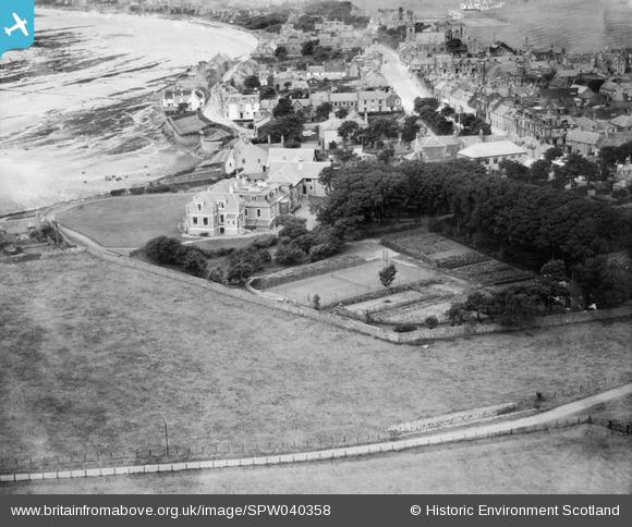
SPW040358 SCOTLAND (1932). Beach Hotel, The Toft, Elie. An oblique aerial photograph taken facing west.
    © Hawlfraint cyfranwyr OpenStreetMap a thrwyddedwyd gan yr OpenStreetMap Foundation. 2025. Trwyddedir y gartograffeg fel CC BY-SA.
  
Delweddau cyfagos (13)
Manylion
| Pennawd | [SPW040358] Beach Hotel, The Toft, Elie. An oblique aerial photograph taken facing west. | 
| Cyfeirnod | SPW040358 | 
| Dyddiad | 1932 | 
| Dolen | NRHE Collection item 1257420 | 
| Enw lle | |
| Plwyf | ELIE | 
| Ardal | NORTH EAST FIFE | 
| Gwlad | SCOTLAND | 
| Dwyreiniad / Gogleddiad | 349376, 699994 | 
| Hydred / Lledred | -2.8157954860645, 56.189943824641 | 
| Cyfeirnod Grid Cenedlaethol | NT4941000 | 
Pinnau
Byddwch y cyntaf i ychwanegu sylw at y ddelwedd hon!
 
             
  ![[SPW040353] Elie, general view, showing The Toft and Woodside Road.  An oblique aerial photograph taken facing north.  This image has been produced from a damaged negative.](http://britainfromabove.org.uk/sites/all/libraries/aerofilms-images/public/100x100/SPW/040/SPW040353.jpg) 
  
                                          ![[SPW040354] Elie, general view, showing The Toft and Woodside Road.  An oblique aerial photograph taken facing north.](http://britainfromabove.org.uk/sites/all/libraries/aerofilms-images/public/100x100/SPW/040/SPW040354.jpg) 
 ![[SPW040355] Beach Hotel, The Toft, Elie.  An oblique aerial photograph taken facing east.](http://britainfromabove.org.uk/sites/all/libraries/aerofilms-images/public/100x100/SPW/040/SPW040355.jpg) 
 ![[SPW040356] Beach Hotel, The Toft, Elie.  An oblique aerial photograph taken facing east.](http://britainfromabove.org.uk/sites/all/libraries/aerofilms-images/public/100x100/SPW/040/SPW040356.jpg) 
 ![[SPW040357] Beach Hotel, The Toft, Elie.  An oblique aerial photograph taken facing north-east.](http://britainfromabove.org.uk/sites/all/libraries/aerofilms-images/public/100x100/SPW/040/SPW040357.jpg) 
 ![[SPW040358] Beach Hotel, The Toft, Elie.  An oblique aerial photograph taken facing west.](http://britainfromabove.org.uk/sites/all/libraries/aerofilms-images/public/100x100/SPW/040/SPW040358.jpg) 
 ![[SPW040359] Elie, general view, showing The Toft and Woodside Road.  An oblique aerial photograph taken facing north.](http://britainfromabove.org.uk/sites/all/libraries/aerofilms-images/public/100x100/SPW/040/SPW040359.jpg) 
 ![[SPW040360] Beach Hotel, The Toft, Elie.  An oblique aerial photograph taken facing north-east.](http://britainfromabove.org.uk/sites/all/libraries/aerofilms-images/public/100x100/SPW/040/SPW040360.jpg) 
 ![[SPW040361] Beach Hotel, The Toft, Elie.  An oblique aerial photograph taken facing east.](http://britainfromabove.org.uk/sites/all/libraries/aerofilms-images/public/100x100/SPW/040/SPW040361.jpg) 
 ![[SPW040362] Beach Hotel, The Toft, Elie.  An oblique aerial photograph taken facing north-east.](http://britainfromabove.org.uk/sites/all/libraries/aerofilms-images/public/100x100/SPW/040/SPW040362.jpg) 
 ![[SPW040363] Beach Hotel, The Toft, Elie.  An oblique aerial photograph taken facing east.](http://britainfromabove.org.uk/sites/all/libraries/aerofilms-images/public/100x100/SPW/040/SPW040363.jpg) 
 ![[SPW040398] Elie, general view, showing Elie Bay and High Street.  An oblique aerial photograph taken facing west.](http://britainfromabove.org.uk/sites/all/libraries/aerofilms-images/public/100x100/SPW/040/SPW040398.jpg) 
 ![[SPW040400] Elie, general view, showing High Street and Parish Church.  An oblique aerial photograph taken facing west.  This image has been produced from a damaged negative.](http://britainfromabove.org.uk/sites/all/libraries/aerofilms-images/public/100x100/SPW/040/SPW040400.jpg)