
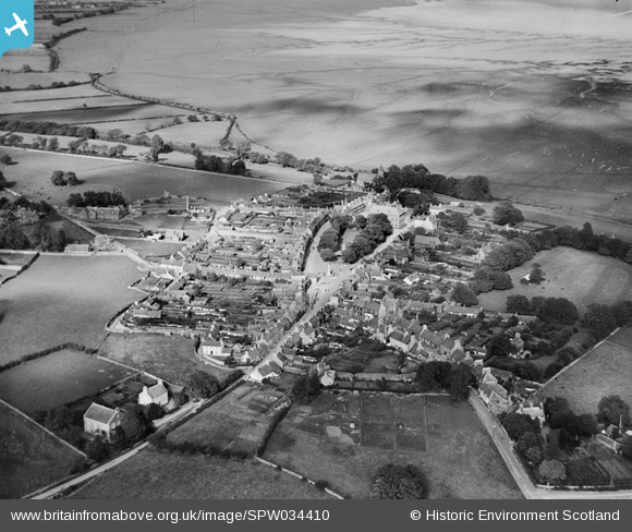
SPW034410 SCOTLAND (1930). Wigtown, general view, showing The Square and High Street. An oblique aerial photograph taken facing north-east.
© Hawlfraint cyfranwyr OpenStreetMap a thrwyddedwyd gan yr OpenStreetMap Foundation. 2026. Trwyddedir y gartograffeg fel CC BY-SA.
Delweddau cyfagos (4)
SPW034410

SPW034409

SPW034408

SPW034411

Manylion
| Pennawd | [SPW034410] Wigtown, general view, showing The Square and High Street. An oblique aerial photograph taken facing north-east. |
| Cyfeirnod | SPW034410 |
| Dyddiad | 1930 |
| Dolen | NRHE Collection item 1257141 |
| Enw lle | |
| Plwyf | WIGTOWN |
| Ardal | WIGTOWN |
| Gwlad | SCOTLAND |
| Dwyreiniad / Gogleddiad | 243308, 555356 |
| Hydred / Lledred | -4.4420120753545, 54.868307013264 |
| Cyfeirnod Grid Cenedlaethol | NX433554 |
Pinnau
Byddwch y cyntaf i ychwanegu sylw at y ddelwedd hon!
Cyfraniadau Grŵp
The Official Book Town of Scotland, with over 20 book related businesses. |
Robert Tims |
Friday 6th of September 2013 03:10:53 PM |