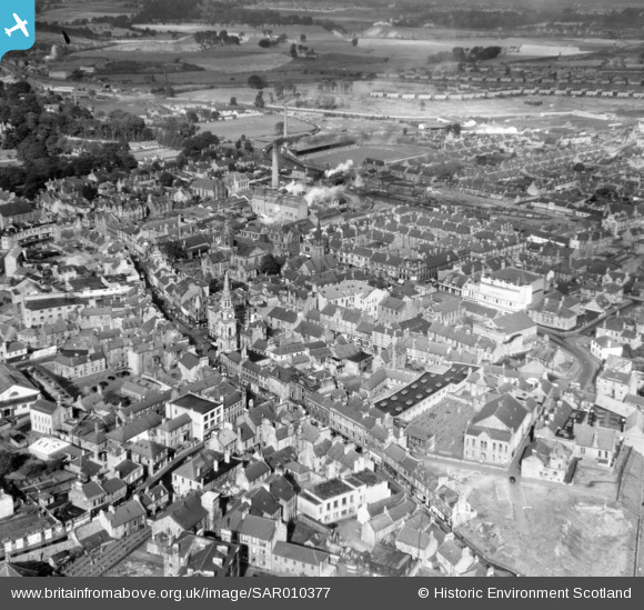
SAR010377 SCOTLAND (1948). General View Falkirk, Stirlingshire, Scotland. An oblique aerial photograph taken facing North/West.
    © Hawlfraint cyfranwyr OpenStreetMap a thrwyddedwyd gan yr OpenStreetMap Foundation. 2025. Trwyddedir y gartograffeg fel CC BY-SA.
  
Delweddau cyfagos (7)
Manylion
| Pennawd | [SAR010377] General View Falkirk, Stirlingshire, Scotland. An oblique aerial photograph taken facing North/West. | 
| Cyfeirnod | SAR010377 | 
| Dyddiad | 1948 | 
| Dolen | NRHE Collection item 1437802 | 
| Enw lle | |
| Plwyf | FALKIRK | 
| Ardal | FALKIRK | 
| Gwlad | SCOTLAND | 
| Dwyreiniad / Gogleddiad | 288818, 679904 | 
| Hydred / Lledred | -3.7829270475741, 55.999225620835 | 
| Cyfeirnod Grid Cenedlaethol | NS888799 | 
Pinnau
|  Police Station |   Bill Carron | Tuesday 8th of September 2020 07:26:19 PM | 
|  Falkirk High Street |   Bill Carron | Tuesday 8th of September 2020 07:18:01 PM | 
|  Cinema - now a Wetherspoon's |   Speed | Thursday 11th of September 2014 11:10:08 PM | 
|  Falkirk swimming baths |   Speed | Thursday 11th of September 2014 11:07:08 PM | 
|  Alexander's furniture shop |   Speed | Wednesday 10th of September 2014 10:49:34 PM | 
|  Salvation Army hall |   Speed | Wednesday 10th of September 2014 10:48:01 PM | 
|  Regal Cinema |   Speed | Wednesday 10th of September 2014 10:43:05 PM | 
|  Brockville Park - home of Falkirk FC - now Morrisons supermarket |   Speed | Wednesday 10th of September 2014 10:40:21 PM | 
|  Library |   Speed | Wednesday 10th of September 2014 10:38:47 PM | 
|  Aitken's Brewery |   Speed | Wednesday 10th of September 2014 10:38:11 PM | 
|  Falkirk Steeple |   Speed | Wednesday 10th of September 2014 10:37:26 PM | 
 
             
  ![[SAR010377] General View Falkirk, Stirlingshire, Scotland. An oblique aerial photograph taken facing North/West.](http://britainfromabove.org.uk/sites/all/libraries/aerofilms-images/public/100x100/SAR/010/SAR010377.jpg) 
  
                                          ![[SAW018846] Falkirk, general view, showing Williamson Street and Town Steeple, High Street.  An oblique aerial photograph taken facing north-west.  This image has been produced from a print.](http://britainfromabove.org.uk/sites/all/libraries/aerofilms-images/public/100x100/SAW/018/SAW018846.jpg) 
 ![[SPW056749] Falkirk, general view, showing Cow Wynd and Grahams Road.  An oblique aerial photograph taken facing north.](http://britainfromabove.org.uk/sites/all/libraries/aerofilms-images/public/100x100/SPW/056/SPW056749.jpg) 
 ![[SPW020263] Falkirk, general view, showing St Andrew's Church and Falkirk Old Parish Church.  An oblique aerial photograph taken facing north.](http://britainfromabove.org.uk/sites/all/libraries/aerofilms-images/public/100x100/SPW/020/SPW020263.jpg) 
 ![[SAW018843] Falkirk, general view, showing Falkirk Old Parish Church, High Street and Grahams Road.  An oblique aerial photograph taken facing north.  This image has been produced from a print.](http://britainfromabove.org.uk/sites/all/libraries/aerofilms-images/public/100x100/SAW/018/SAW018843.jpg) 
 ![[SPW056747] Falkirk, general view, showing High Street and Brockville Football Stadium.  An oblique aerial photograph taken facing north-west.](http://britainfromabove.org.uk/sites/all/libraries/aerofilms-images/public/100x100/SPW/056/SPW056747.jpg) 
 ![[SAW018845] Falkirk, general view, showing Dollar Park and Weir Street.  An oblique aerial photograph taken facing east.  This image has been produced from a print.](http://britainfromabove.org.uk/sites/all/libraries/aerofilms-images/public/100x100/SAW/018/SAW018845.jpg)