
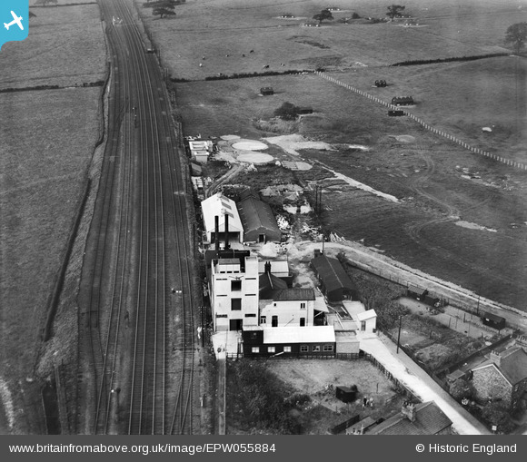
EPW055884 ENGLAND (1937). The Garstang Creamery on Kenlis Road, Bowgreave, 1937
© Hawlfraint cyfranwyr OpenStreetMap a thrwyddedwyd gan yr OpenStreetMap Foundation. 2026. Trwyddedir y gartograffeg fel CC BY-SA.
Delweddau cyfagos (6)
EPW055884

 0°
0m
0°
0m
EPW055888
 47°
16m
47°
16m
EPW055885
 162°
22m
162°
22m
EPW055887
 192°
32m
192°
32m
EPW055886
 35°
33m
35°
33m
EPW055883
 145°
38m
145°
38m
Manylion
| Pennawd | [EPW055884] The Garstang Creamery on Kenlis Road, Bowgreave, 1937 |
| Cyfeirnod | EPW055884 |
| Dyddiad | 24-October-1937 |
| Dolen | |
| Enw lle | BOWGREAVE |
| Plwyf | BARNACRE-WITH-BONDS |
| Ardal | |
| Gwlad | ENGLAND |
| Dwyreiniad / Gogleddiad | 350950, 444096 |
| Hydred / Lledred | -2.7464104761717, 53.890518108573 |
| Cyfeirnod Grid Cenedlaethol | SD510441 |
Pinnau
 This shows the five railway tracks - the two LMS Mainlines ( Glasgow -> Euston ) plus the branch line to. Garstang Town ( and originally Knott End ) - plus two sidings . This shows the five railway tracks - the two LMS Mainlines ( Glasgow -> Euston ) plus the branch line to. Garstang Town ( and originally Knott End ) - plus two sidings . |

Fifty - Plus |
Thursday 27th of August 2026 10:18:34 PM |
| One of six pictures in this series.
I believe this building's name was the Tokyo Creamery. |
Fifty - Plus |
Thursday 27th of August 2026 10:08:13 PM |