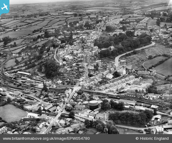
EPW054780 ENGLAND (1937). The town, Launceston, from the north-west, 1937
    © Hawlfraint cyfranwyr OpenStreetMap a thrwyddedwyd gan yr OpenStreetMap Foundation. 2025. Trwyddedir y gartograffeg fel CC BY-SA.
  
Manylion
| Pennawd | [EPW054780] The town, Launceston, from the north-west, 1937 | 
| Cyfeirnod | EPW054780 | 
| Dyddiad | August-1937 | 
| Dolen | |
| Enw lle | LAUNCESTON | 
| Plwyf | LAUNCESTON | 
| Ardal | |
| Gwlad | ENGLAND | 
| Dwyreiniad / Gogleddiad | 232943, 84952 | 
| Hydred / Lledred | -4.3628671033499, 50.639699507506 | 
| Cyfeirnod Grid Cenedlaethol | SX329850 | 
 
             
  ![[EPW054780] The town, Launceston, from the north-west, 1937](http://britainfromabove.org.uk/sites/all/libraries/aerofilms-images/public/100x100/EPW/054/EPW054780.jpg) 
  
                                          ![[EPW023647] St Thomas, Launceston, 1928](http://britainfromabove.org.uk/sites/all/libraries/aerofilms-images/public/100x100/EPW/023/EPW023647.jpg) 
 ![[EPW023644] St Thomas Hill, Launceston, from the north-west, 1928](http://britainfromabove.org.uk/sites/all/libraries/aerofilms-images/public/100x100/EPW/023/EPW023644.jpg) 
 ![[EAW014991] Launceston Castle above the town, Launceston, 1948. This image has been produced from a print.](http://britainfromabove.org.uk/sites/all/libraries/aerofilms-images/public/100x100/EAW/014/EAW014991.jpg) 
  Southern rly station
 Southern rly station 