
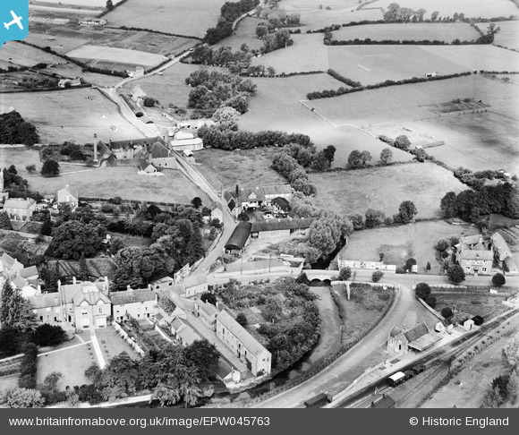
EPW045763 ENGLAND (1934). Wiltshire Creameries Ltd, Stanesbridge House and environs, Malmesbury, 1934
© Hawlfraint cyfranwyr OpenStreetMap a thrwyddedwyd gan yr OpenStreetMap Foundation. 2026. Trwyddedir y gartograffeg fel CC BY-SA.
Delweddau cyfagos (5)
EPW045763

EPW045762

EPW045761

EPW045765

EPW045764

Manylion
| Pennawd | [EPW045763] Wiltshire Creameries Ltd, Stanesbridge House and environs, Malmesbury, 1934 |
| Cyfeirnod | EPW045763 |
| Dyddiad | August-1934 |
| Dolen | |
| Enw lle | MALMESBURY |
| Plwyf | MALMESBURY |
| Ardal | |
| Gwlad | ENGLAND |
| Dwyreiniad / Gogleddiad | 392992, 187776 |
| Hydred / Lledred | -2.101166661153, 51.588320495349 |
| Cyfeirnod Grid Cenedlaethol | ST930878 |
Pinnau
David Parry |
Thursday 9th of May 2013 09:03:01 AM | |
David Parry |
Thursday 9th of May 2013 09:01:43 AM | |
David Parry |
Tuesday 7th of May 2013 03:55:00 PM | |
This was the terminus of the Great Western branch line from Dauntsey. Line closed in 1962. |
David Parry |
Tuesday 7th of May 2013 03:56:17 PM |
Did you know that Malmesbury Station was one of 200 'stopping stations' where wounded and sick men and women were received for onward transfer to local hospital by car and ambulance/ Where might they have been taken? |
Lynda Tubbs |
Tuesday 4th of March 2014 02:11:18 PM |