
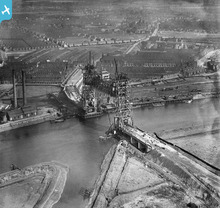
EPW042125 ENGLAND (1933). The Tees Newport Bridge under construction, Middlesbrough, 1933

© Hawlfraint cyfranwyr OpenStreetMap a thrwyddedwyd gan yr OpenStreetMap Foundation. 2026. Trwyddedir y gartograffeg fel CC BY-SA.
Delweddau cyfagos (7)
EPW042125

EAW024129
 Bridge, Middlesbrough, 1949")
EPW042126

EAW024130
 Bridge, Middlesbrough, 1949")
EAW024128
 Bridge, Middlesbrough, 1949")
EAW013849

EAW024126

Manylion
| Pennawd | [EPW042125] The Tees Newport Bridge under construction, Middlesbrough, 1933 |
| Cyfeirnod | EPW042125 |
| Dyddiad | June-1933 |
| Dolen | |
| Enw lle | MIDDLESBROUGH |
| Plwyf | |
| Ardal | |
| Gwlad | ENGLAND |
| Dwyreiniad / Gogleddiad | 447899, 519834 |
| Hydred / Lledred | -1.2590096692304, 54.571330406886 |
| Cyfeirnod Grid Cenedlaethol | NZ479198 |
Pinnau

Prospector |
Sunday 13th of September 2020 11:14:29 PM | |
|
Steptoe |
Tuesday 13th of March 2018 09:30:55 AM | |
|
David Crawford |
Sunday 27th of September 2015 10:57:18 PM | |
|
km |
Monday 16th of June 2014 08:34:22 PM | |
|
Ali |
Saturday 15th of June 2013 08:02:41 PM | |
|
Ali |
Saturday 15th of June 2013 08:02:08 PM | |
|
Ali |
Saturday 15th of June 2013 08:01:29 PM | |
|
Ali |
Saturday 15th of June 2013 08:00:57 PM | |
|
Ali |
Saturday 15th of June 2013 08:00:15 PM | |
|
Chells809 |
Saturday 18th of May 2013 09:57:02 PM |
Cyfraniadau Grŵp
The Tees Newport Bridge under construction, Middlesbrough, 1933 |
Ali |
Friday 14th of June 2013 04:45:07 PM |