
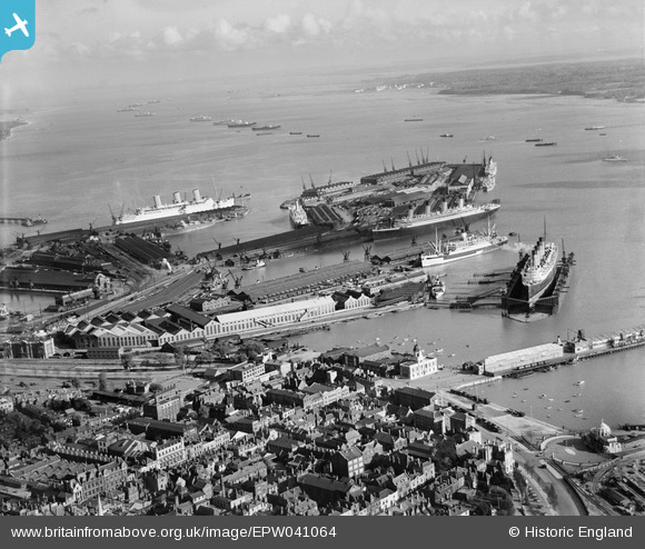
EPW041064 ENGLAND (1933). Ocean Dock, the RMS Mauretania in the floating dry dock and environs, Southampton, from the north-west, 1933
© Hawlfraint cyfranwyr OpenStreetMap a thrwyddedwyd gan yr OpenStreetMap Foundation. 2026. Trwyddedir y gartograffeg fel CC BY-SA.
Delweddau cyfagos (17)
EPW041064

EAW001347

EAW008798

EAW008801

EAW008791

EPW032342

EPW041065

EAW008795

EAW008796

EAW008800

EAW001375

EPW039727

EAW008803

EAW008802

EPW009077

EPW042958

EPW042962

Manylion
| Pennawd | [EPW041064] Ocean Dock, the RMS Mauretania in the floating dry dock and environs, Southampton, from the north-west, 1933 |
| Cyfeirnod | EPW041064 |
| Dyddiad | April-1933 |
| Dolen | |
| Enw lle | SOUTHAMPTON |
| Plwyf | |
| Ardal | |
| Gwlad | ENGLAND |
| Dwyreiniad / Gogleddiad | 442156, 110928 |
| Hydred / Lledred | -1.4005097331126, 50.895738334619 |
| Cyfeirnod Grid Cenedlaethol | SU422109 |
Pinnau

Isleworth1961 |
Saturday 10th of February 2018 12:54:40 AM | |
|
Jose |
Sunday 29th of March 2015 12:50:20 AM | |
|
Jose |
Sunday 29th of March 2015 12:43:35 AM | |
|
Graham Yaxley |
Sunday 4th of January 2015 11:39:16 PM | |
|
Graham Yaxley |
Sunday 4th of January 2015 11:38:32 PM | |
|
chainbull |
Friday 1st of August 2014 08:46:46 PM |
Cyfraniadau Grŵp
Southampton Docks 01/05/2014 |

Class31 |
Friday 2nd of May 2014 03:57:34 PM |