
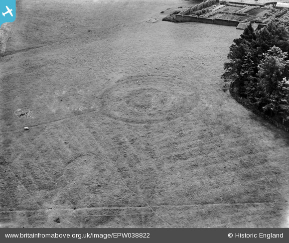
EPW038822 ENGLAND (1932). Earthworks in Wennington Park, Wennington, 1932
© Hawlfraint cyfranwyr OpenStreetMap a thrwyddedwyd gan yr OpenStreetMap Foundation. 2026. Trwyddedir y gartograffeg fel CC BY-SA.
Delweddau cyfagos (3)
EPW038822

EPW038821

EPW038823

Manylion
| Pennawd | [EPW038822] Earthworks in Wennington Park, Wennington, 1932 |
| Cyfeirnod | EPW038822 |
| Dyddiad | 30-June-1932 |
| Dolen | |
| Enw lle | WENNINGTON |
| Plwyf | WENNINGTON |
| Ardal | |
| Gwlad | ENGLAND |
| Dwyreiniad / Gogleddiad | 361638, 470593 |
| Hydred / Lledred | -2.5871212936631, 54.129580059845 |
| Cyfeirnod Grid Cenedlaethol | SD616706 |
Pinnau

TheBlueCube |
Wednesday 23rd of January 2013 07:24:34 PM | |
|
TheBlueCube |
Wednesday 23rd of January 2013 07:23:43 PM | |
|
TheBlueCube |
Wednesday 23rd of January 2013 07:22:54 PM | |
|
EastMarple1 |
Wednesday 19th of December 2012 09:35:24 AM |
Cyfraniadau Grŵp

Very close to the circular feature in EPW038821, near Wennington Hall School, Lancashire. I can't see this on Google Maps (though the feature in EPW038821 is visible) and cannot find any reference. |
David Parry |
Sunday 10th of March 2013 09:44:33 PM |
Hi Dylan, Great spot! Thank you, this and the two other images of the earthwork are really tricky so it's great to have them identified. The original Aerofilms Ltd Register entry is "Wellington". Close, but not close enough, to the actual place name! We'll update the catalogue entry, and post the new data here in due course. Yours, Katy Britain from Above Cataloguing Team Leader |
Katy Whitaker |
Friday 8th of March 2013 03:21:12 PM |
Wennington Hall, Lancs. A faint boundary bank passing across the earthwork was not on contemporary maps, but is now re-established. Unfortunately the earthwork does not appear on any map edition that I have seen. However, the location is established unambiguously by the structure of the nearby walled garden, with a D-shaped extension on the southern wall. A glasshouse is seen within this in the picture, and is shown in the contemporary (1913 & 1894) 1:2500 OS maps. |

Dylan Moore |
Monday 25th of February 2013 02:08:06 PM |
possibly Ditchfield hall grounds in background right, much of the area was developed after the war for prefab and council housing. one, possibly two circles were reported from wartime aerial photography within this area of Ditton |
Beverley |
Friday 8th of February 2013 04:28:11 PM |
Hi Beverley, Interesting suggestion, thanks for looking into this image. I've been looking at the OS for Ditchfield Hall but can't make the mapped boundaries of the premises fit with this walled garden. Unfortunately there is no information at all in the original Aerofilms Ltd Register entry for the photo. The company visited locations in Northumberland before and Tunstall after they took this shot. Yours, Katy Britain from Above Cataloguing Team Leader |
Katy Whitaker |
Friday 8th of February 2013 04:28:11 PM |
possibly field markings near the Ditton area of Widnes formerly Lancashire (now in Cheshire) |
Beverley |
Friday 8th of February 2013 01:30:28 PM |
The walled garden in the top right, together with the heated greenhouse & the mixed varieties of tree in the plantation suggest that this is a photo of the surroundings of a large, probably Victorian, mansion house. There is a possibility of adjacent ancient archaeological features in the featured field, eg; the concentric circles & the 'straight' horizontal line in the foreround. |
TheBlueCube |
Wednesday 23rd of January 2013 07:31:19 PM |
Some sort of Bronze Age round barrow - maybe a disc barrow - with ridge and furrow respecting it. Walled garden of what is presumably a large estate house in background. Salisbury Plain or general Wiltshire/Dorset/Hampshire area? |
Rebecca |
Wednesday 9th of January 2013 10:45:47 AM |