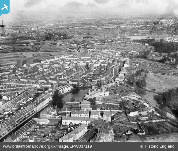
EPW037119 ENGLAND (1931). Housing surrounding Wick Road and Sutton Avenue, Brislington, from the south, 1931
© Hawlfraint cyfranwyr OpenStreetMap a thrwyddedwyd gan yr OpenStreetMap Foundation. 2026. Trwyddedir y gartograffeg fel CC BY-SA.
Delweddau cyfagos (11)
Manylion
| Pennawd | [EPW037119] Housing surrounding Wick Road and Sutton Avenue, Brislington, from the south, 1931 |
| Cyfeirnod | EPW037119 |
| Dyddiad | October-1931 |
| Dolen | |
| Enw lle | BRISLINGTON |
| Plwyf | |
| Ardal | |
| Gwlad | ENGLAND |
| Dwyreiniad / Gogleddiad | 361851, 171574 |
| Hydred / Lledred | -2.5489472239662, 51.441382759067 |
| Cyfeirnod Grid Cenedlaethol | ST619716 |
Pinnau

kellysheppard510@ymail.com |
Sunday 26th of October 2014 06:32:30 PM | |

kellysheppard510@ymail.com |
Sunday 26th of October 2014 06:30:26 PM | |

kellysheppard510@ymail.com |
Sunday 26th of October 2014 06:29:20 PM | |

Class31 |
Sunday 3rd of February 2013 10:30:33 PM | |

Class31 |
Sunday 3rd of February 2013 10:23:47 PM | |

Class31 |
Sunday 3rd of February 2013 09:44:39 PM | |

pe175 |
Tuesday 8th of January 2013 10:45:38 PM | |

pe175 |
Tuesday 8th of January 2013 10:44:57 PM | |

pe175 |
Tuesday 8th of January 2013 10:42:57 PM |


![[EPW037119] Housing surrounding Wick Road and Sutton Avenue, Brislington, from the south, 1931](http://britainfromabove.org.uk/sites/all/libraries/aerofilms-images/public/100x100/EPW/037/EPW037119.jpg)
![[EPW037123] Housing surrounding Wick Road and Sutton Avenue, Brislington, from the south, 1931](http://britainfromabove.org.uk/sites/all/libraries/aerofilms-images/public/100x100/EPW/037/EPW037123.jpg)
![[EPW037122] Housing surrounding Wick Road and Sutton Avenue, Brislington, from the south-east, 1931](http://britainfromabove.org.uk/sites/all/libraries/aerofilms-images/public/100x100/EPW/037/EPW037122.jpg)
![[EPW037124] Housing surrounding Sandwich Road, Wick Road and Sutton Avenue, Brislington, from the south-west, 1931](http://britainfromabove.org.uk/sites/all/libraries/aerofilms-images/public/100x100/EPW/037/EPW037124.jpg)
![[EPW037121] Housing surrounding Sandringham Road, Wick Road and Sutton Avenue, Brislington, from the south-west, 1931](http://britainfromabove.org.uk/sites/all/libraries/aerofilms-images/public/100x100/EPW/037/EPW037121.jpg)
![[EPW037116] Housing surrounding Sutton Avenue and Wick Road, Brislington, 1931](http://britainfromabove.org.uk/sites/all/libraries/aerofilms-images/public/100x100/EPW/037/EPW037116.jpg)
![[EPW037115] Housing surrounding Sutton Avenue and Wick Road, Brislington, 1931](http://britainfromabove.org.uk/sites/all/libraries/aerofilms-images/public/100x100/EPW/037/EPW037115.jpg)
![[EPW037120] Housing surrounding Wick Road and Sutton Avenue, Brislington, from the south, 1931](http://britainfromabove.org.uk/sites/all/libraries/aerofilms-images/public/100x100/EPW/037/EPW037120.jpg)
![[EPW037114] Housing surrounding Sutton Avenue and Wick Road, Brislington, 1931](http://britainfromabove.org.uk/sites/all/libraries/aerofilms-images/public/100x100/EPW/037/EPW037114.jpg)
![[EPW037117] Housing surrounding Sunny Dene and Wick Road, Brislington, 1931](http://britainfromabove.org.uk/sites/all/libraries/aerofilms-images/public/100x100/EPW/037/EPW037117.jpg)
![[EPW037118] Housing surrounding Sunny Dene, Collin Road and Wick Road, Brislington, 1931](http://britainfromabove.org.uk/sites/all/libraries/aerofilms-images/public/100x100/EPW/037/EPW037118.jpg)