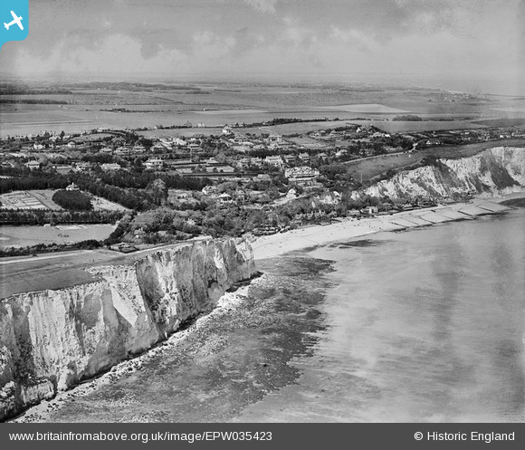
EPW035423 ENGLAND (1931). St Margaret's Bay, Ness Point and the village, St Margaret's-at-Cliffe, from the south-east, 1931
    © Hawlfraint cyfranwyr OpenStreetMap a thrwyddedwyd gan yr OpenStreetMap Foundation. 2025. Trwyddedir y gartograffeg fel CC BY-SA.
  
Delweddau cyfagos (5)
Manylion
| Pennawd | [EPW035423] St Margaret's Bay, Ness Point and the village, St Margaret's-at-Cliffe, from the south-east, 1931 | 
| Cyfeirnod | EPW035423 | 
| Dyddiad | May-1931 | 
| Dolen | |
| Enw lle | ST MARGARET'S-AT-CLIFFE | 
| Plwyf | ST. MARGARET'S AT CLIFFE | 
| Ardal | |
| Gwlad | ENGLAND | 
| Dwyreiniad / Gogleddiad | 636829, 144206 | 
| Hydred / Lledred | 1.3865850810117, 51.147509793978 | 
| Cyfeirnod Grid Cenedlaethol | TR368442 | 
Pinnau
Byddwch y cyntaf i ychwanegu sylw at y ddelwedd hon!
 
             
  ![[EPW035423] St Margaret's Bay, Ness Point and the village, St Margaret's-at-Cliffe, from the south-east, 1931](http://britainfromabove.org.uk/sites/all/libraries/aerofilms-images/public/100x100/EPW/035/EPW035423.jpg) 
  
                                          ![[EPW000674] St Margaret's Bay, St Margaret's at Cliffe, from the south-east, 1920](http://britainfromabove.org.uk/sites/all/libraries/aerofilms-images/public/100x100/EPW/000/EPW000674.jpg) 
 ![[EPW000673] St Margaret's Bay, St Margaret's at Cliffe, from the south-west, 1920](http://britainfromabove.org.uk/sites/all/libraries/aerofilms-images/public/100x100/EPW/000/EPW000673.jpg) 
 ![[EPW035425] St Margaret's Bay and the village, St Margaret's-at-Cliffe, 1931](http://britainfromabove.org.uk/sites/all/libraries/aerofilms-images/public/100x100/EPW/035/EPW035425.jpg) 
 ![[EAW020465] St Margaret's Road and environs, St Margaret's at Cliffe, 1948](http://britainfromabove.org.uk/sites/all/libraries/aerofilms-images/public/100x100/EAW/020/EAW020465.jpg)