
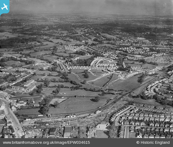
EPW034615 ENGLAND (1930). A new housing estate under construction near Lower Hale, Edgware, from the south-west, 1930
© Hawlfraint cyfranwyr OpenStreetMap a thrwyddedwyd gan yr OpenStreetMap Foundation. 2026. Trwyddedir y gartograffeg fel CC BY-SA.
Delweddau cyfagos (29)
EPW034615

EPW034613

EPW034610

EAW020694

EPW009349

EPW034614

EPW034554

EPW034609

EPW009374

EPW031551

EPW031554

EPW034620

EPW015770

EAW020695

EPW016514

EPW031556

EPW009341

EPW009342

EPW016513

EPW034561

EPW009343

EPW009603

EPW031553

EAW048861

EPW009376

EPW009373

EPW015982

EPW005282

EPW034618

Manylion
| Pennawd | [EPW034615] A new housing estate under construction near Lower Hale, Edgware, from the south-west, 1930 |
| Cyfeirnod | EPW034615 |
| Dyddiad | 16-October-1930 |
| Dolen | |
| Enw lle | EDGWARE |
| Plwyf | |
| Ardal | |
| Gwlad | ENGLAND |
| Dwyreiniad / Gogleddiad | 519688, 191802 |
| Hydred / Lledred | -0.27124585622498, 51.61183870816 |
| Cyfeirnod Grid Cenedlaethol | TQ197918 |
Pinnau

Class31 |
Wednesday 7th of August 2013 11:44:55 PM | |
|
Class31 |
Wednesday 7th of August 2013 11:44:29 PM | |
|
Class31 |
Wednesday 7th of August 2013 11:43:56 PM | |
|
Class31 |
Wednesday 7th of August 2013 11:43:10 PM | |
|
Class31 |
Wednesday 7th of August 2013 11:42:36 PM | |
|
Class31 |
Wednesday 7th of August 2013 11:42:20 PM | |
|
Class31 |
Wednesday 7th of August 2013 11:41:36 PM | |
|
Class31 |
Wednesday 7th of August 2013 11:40:52 PM |