
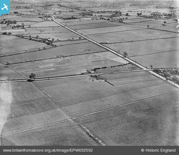
EPW032592 ENGLAND (1930). Trial plots and cultivated fields around the Runcorn Road, Little Leigh, from the north-west, 1930
© Hawlfraint cyfranwyr OpenStreetMap a thrwyddedwyd gan yr OpenStreetMap Foundation. 2026. Trwyddedir y gartograffeg fel CC BY-SA.
Delweddau cyfagos (13)
EPW032592

EPW032588

EAW017277

EAW017282

EAW017279

EAW017278

EAW016759

EAW016764

EAW017276

EAW017280

EPW057549

EAW016763

EAW030022

Manylion
| Pennawd | [EPW032592] Trial plots and cultivated fields around the Runcorn Road, Little Leigh, from the north-west, 1930 |
| Cyfeirnod | EPW032592 |
| Dyddiad | June-1930 |
| Dolen | |
| Enw lle | LITTLE LEIGH |
| Plwyf | LITTLE LEIGH |
| Ardal | |
| Gwlad | ENGLAND |
| Dwyreiniad / Gogleddiad | 361081, 377234 |
| Hydred / Lledred | -2.5839089241581, 53.290365004028 |
| Cyfeirnod Grid Cenedlaethol | SJ611772 |
Pinnau

Dylan Moore |
Sunday 3rd of March 2013 08:09:33 PM | |
|
Dylan Moore |
Sunday 3rd of March 2013 08:05:13 PM | |
|
Dylan Moore |
Sunday 3rd of March 2013 08:03:08 PM | |

Class31 |
Thursday 28th of February 2013 07:54:12 PM | |
|
Class31 |
Thursday 28th of February 2013 06:50:43 PM | |
|
Class31 |
Thursday 28th of February 2013 06:49:29 PM | |
|
Class31 |
Thursday 28th of February 2013 06:48:58 PM | |
|
Class31 |
Thursday 28th of February 2013 06:48:20 PM | |
|
Class31 |
Wednesday 23rd of January 2013 09:18:09 AM | |
To me, this looks like a river which is curving away to the left. I get the impression that the nearer part is in a valley partly obscured by a small hill, and that the far part must pass close to the visible housing. |

Tony D |
Wednesday 23rd of January 2013 09:52:00 AM |
Having said that, I can't find any sign of a river on the adjoining EPW032588, so I'm now wondering if the river loops again to the right as it gets nearer the camera; there is a small patch of white further down and left, which may lead to a small valley which exits the picture just beyond the church spire marked. |
Tony D |
Wednesday 23rd of January 2013 10:14:02 AM |
Little Leigh Pond |
Class31 |
Thursday 28th of February 2013 06:55:41 PM |
Surely it's the River Weaver, most likely the Barnton Cut. Little Leigh Pond is slightly south west of Little Leigh and its church, so will be off the right of this photo (as well as hidden because it's at the bottom of the slope, near the Trent and Mersey Canal, also hidden). |
Tony D |
Thursday 28th of February 2013 07:35:02 PM |
|
Chris Willis |
Saturday 12th of January 2013 07:29:59 PM | |
|
Chris Willis |
Saturday 12th of January 2013 07:26:53 PM | |
|
MB |
Saturday 15th of December 2012 11:24:22 AM | |
St Michael and All Angels Church, Little Leigh |
Class31 |
Thursday 28th of February 2013 07:10:59 PM |
|
MB |
Saturday 15th of December 2012 11:23:47 AM | |
|
MB |
Saturday 15th of December 2012 11:22:43 AM |
Cyfraniadau Grŵp
Well done Dylan Moore for identifying this series of 13 photos. |
Class31 |
Thursday 7th of March 2013 05:10:46 PM |
All of this group of images around Caltterwick are now identified! We'll update the catalogue and post the new data here in due course, thank you very much. Yours, Katy Britain from Above Cataloguing Team Leader |
Katy Whitaker |
Thursday 7th of March 2013 05:10:46 PM |
The set EPW032580 to EPW032591 are all in the same area and part of the same series - same fields, houses, roads, dew ponds etc feature in them all. |
Rebecca |
Wednesday 9th of January 2013 02:55:31 PM |