
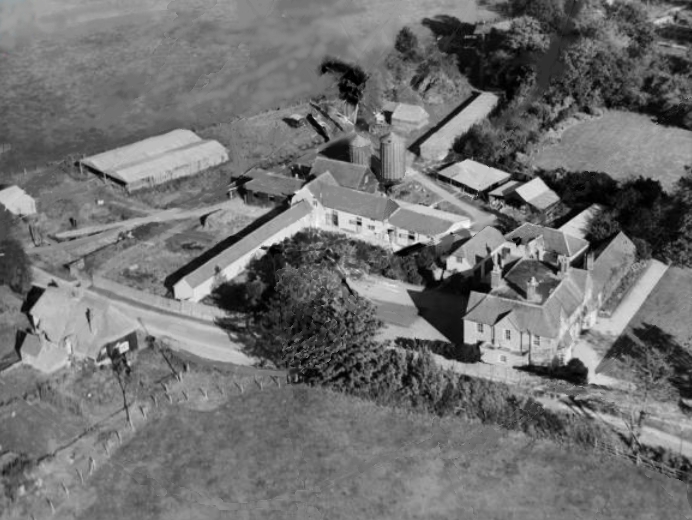
EPW031088 ENGLAND (1929). Ecchinswell House, Ecchinswell, 1929. This image has been produced from a damaged negative.

© Hawlfraint cyfranwyr OpenStreetMap a thrwyddedwyd gan yr OpenStreetMap Foundation. 2026. Trwyddedir y gartograffeg fel CC BY-SA.
Delweddau cyfagos (3)
EPW031088

EPW031086A

EPW031087A

Manylion
| Pennawd | [EPW031088] Ecchinswell House, Ecchinswell, 1929. This image has been produced from a damaged negative. |
| Cyfeirnod | EPW031088 |
| Dyddiad | October-1929 |
| Dolen | |
| Enw lle | ECCHINSWELL |
| Plwyf | ECCHINSWELL, SYDMONTON AND BISHOPS GREEN |
| Ardal | |
| Gwlad | ENGLAND |
| Dwyreiniad / Gogleddiad | 450253, 160262 |
| Hydred / Lledred | -1.27849630396, 51.33872087796 |
| Cyfeirnod Grid Cenedlaethol | SU503603 |
Pinnau

Cyfraniadau Grŵp
Ecchinswell House, near Newbury. |

Tony D |
Tuesday 2nd of July 2013 11:48:20 AM |
Hi Tony D, So pleasing to get this set of images that are tied to various aviation "names"! We'll update the catalogue and post the new record here in due course. Yours, Katy Britain from Above Cataloguing Team Leader |
Katy Whitaker |
Tuesday 2nd of July 2013 11:48:20 AM |
I had a little go at repairing this one, hopefully it might make it more recognisable. |
rog8811 |
Friday 17th of May 2013 04:16:36 PM |
Great rog8811 nowadays with Photoshop nothing is beyond repair! |
Allen T |
Friday 17th of May 2013 04:16:36 PM |
One of a series of 10 photos, EPW031086A, EPW031087A, EPW031088-EPW031091 and EPW031093-EPW031096. Manor House 2 appears to be the focus as it is featured in three closeups (EPW031086A, EPW031087A, EPW031088) so this may have been where the air meet was based. |
Rebecca |
Wednesday 9th of January 2013 04:23:55 PM |
Manor House 2. |
Rebecca |
Wednesday 9th of January 2013 04:23:50 PM |
This is the same farm that can be seen in the background of the next few airfield shots |
TomRobin |
Tuesday 23rd of October 2012 10:40:43 AM |